
AI GIS and Mapping Tools for Architects and Planners (2026): Giraffe, Felt, CARTO, Aino and ArcGIS GeoAI
Ask a map a question in plain words and get a layer back. What five AI mapping platforms really do, who each one is for, what they cost where prices are published, and how to check what the AI gives you.
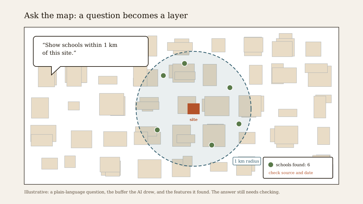
For thirty years, getting an answer out of a geographic information system meant learning its menus: load the layers, set the projection, buffer, intersect, symbolise, export. In 2025 and 2026 that changed quickly. Mapping platforms now let you type a question, such as "show schools within one kilometre of this site" or "which parcels here could take a six-storey block", and an AI model works out the steps, runs them and draws the result.
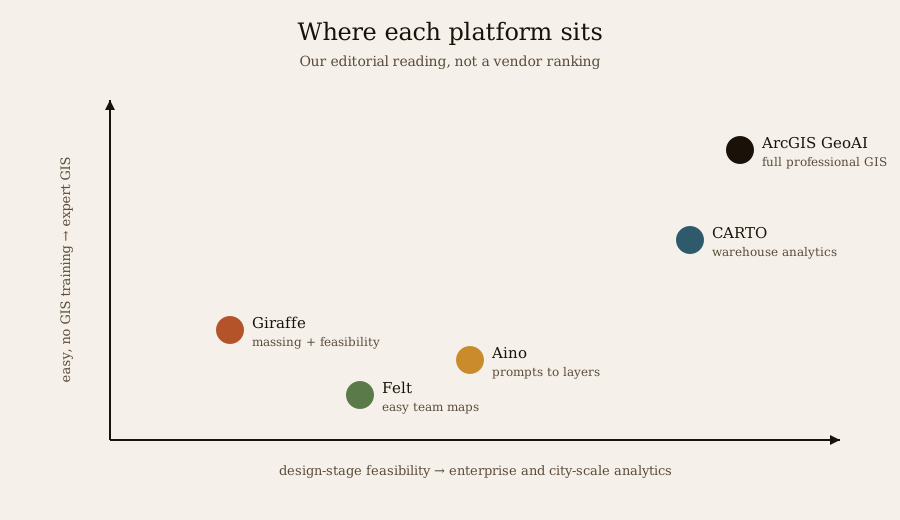
This guide looks at five platforms architects and planners ask about most: Giraffe, Felt, CARTO, Aino and ArcGIS GeoAI. They are very different products that happen to share a new way of talking to maps. For each we cover what it is for, what the AI part actually does, who uses it, and what it costs where the price is published. Then come the parts the demos skip: how to check AI map output, what happens to your site's location, and what to expect from Indian data.
This guide describes third-party software as of November 2026. AI features in particular change month by month, and several are labelled preview or beta by their makers. Capability statements from vendors' own pages are marked as claims. Studio Matrx has no commercial relationship with any company named here.
How "ask the map" works
All five tools follow roughly the same loop. Understanding it tells you where errors creep in.
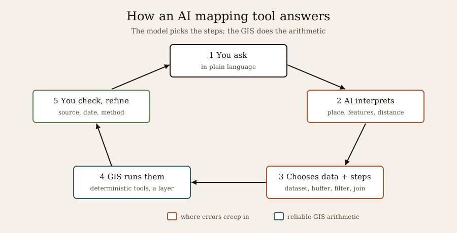
1. You ask in plain language.
2. A language model interprets the question: which place, which features, which distance or rule.
3. It chooses data and steps: a dataset (roads, buildings, census, OpenStreetMap), and operations such as buffer, filter or join.
4. The platform runs them with ordinary, deterministic GIS tools, and draws a layer, chart or table.
5. You check and refine, often by asking a follow-up.
The good news is that step 4 is the same reliable GIS arithmetic as before. The risk sits in steps 2 and 3: the model may pick the wrong dataset, misread "within 1 km" as a straight line when you meant walking distance, or silently use data that is years old. The better platforms now show their working, which is the single most important feature to look for.
Many of these tools also expose themselves to outside AI assistants through the Model Context Protocol (MCP), an open way for assistants such as Claude, ChatGPT or Gemini to call a platform's tools. That means you may meet the same mapping engine inside a chat window rather than its own website.
The five platforms
Giraffe: feasibility on a shared map
Giraffe is a browser-based platform for early-stage real-estate development and urban design. It puts zoning, parcel and tax data on one map, lets you sketch building masses with simple parametric tools, and ties them to a live financial model, so yield and returns update as the scheme changes. Its users are developers, urban designers and planners at the pre-design stage.
The AI part. Giraffe's own knowledge base (April 2026) says its AI "uses Claude — Anthropic's large language model — as the interface to control the platform", working with your data, assumptions and product types. A Giraffe blog post of 28 April 2026 describes a workflow orchestrator for AI agents that run steps such as site-boundary retrieval and context analysis, with development teams "piloting" end-to-end feasibility sequences. Treat the agents as an early capability.
Price. Giraffe's pricing is sales-led; third-party trackers quote conflicting starting prices. Ask Giraffe directly.
Felt: easy cloud maps that answer back
Felt is a cloud mapping platform built to be easy for people who are not GIS specialists: drop in data, style it, and share maps, dashboards and apps with a team, with spatial SQL underneath for experts.
The AI part. Felt AI is an assistant inside the map: you ask a spatial question and it finds the data, runs the analysis and puts the answer on the map, including raster work such as zonal statistics and elevation profiles. In April 2026 Felt launched an MCP server, which it describes as one endpoint with 30 tools, so assistants such as Claude, ChatGPT or Gemini can build and query Felt maps.
Price (published 13 October 2026). A Free plan ("free forever", 3 seats and 25 viewers); Team at US$199 a month billed yearly (US$249 monthly) with 250 Felt AI credits a month; Business at US$599 a month billed yearly (US$749 monthly) with 1,000 credits and MCP; Enterprise from US$1,250 a month, yearly. A free Classroom plan exists for teaching in higher education.
CARTO: agentic analytics on company data
CARTO is a spatial-analytics platform that runs on top of a company's own cloud data warehouse (Google BigQuery, Snowflake, Databricks, Amazon, Oracle and others). Its users are analysts in retail, telecoms, logistics, real estate and government, often for site selection and network planning.
The AI part. CARTO AI Agents answer questions and run analyses on that data, and since the second quarter of 2026 show "tool traceability": which tools an agent ran, with what parameters, and the SQL it generated. CARTO for Agents (described in CARTO's Q2 2026 update, July 2026) brings the platform into outside assistants through a command-line tool, a hosted MCP server and packaged agent skills. CARTO also announced a Site Selection Agent on Google's Gemini Enterprise agent marketplace in April 2026.
Price. Enterprise, on request.
Aino: prompts become map layers
Aino (aino.world) is an AI-first spatial-analysis platform: you type a question in plain words and it builds interactive maps, charts and analyses from more than twenty data sources, including OpenStreetMap, terrain, transport networks, business directories and US census data. A QGIS plug-in turns prompts such as "parks in Barcelona" into vector layers of OpenStreetMap data inside QGIS.
The AI part. It is the whole product. A 2026 review describes modes from basic styling, through AI-generated categorical, heat and gradient maps, to an expert mode that runs a "Geo Reasoning" agent for multi-step analysis. Buffer and accessibility questions can be asked in plain language.
Price. Basic features are free with an account, according to a June 2026 review; paid tiers were not publicly listed when we checked.
ArcGIS GeoAI: AI across the industry-standard GIS
Esri's ArcGIS is the GIS most governments, utilities and large consultancies use, and Esri has been adding AI across it under the GeoAI name.
The AI part, in three layers.
- Pretrained deep-learning models: Esri offers more than 100 ready-to-use models through ArcGIS Living Atlas, for tasks such as detecting trees and buildings, extracting roads and classifying land cover from imagery. In 2026 Esri added foundation models and location embeddings.
- AI assistants inside the apps: in June 2026 Esri made the Survey123 assistant (which turns a plain-language description of a field form into a survey), the Business Analyst assistant and a translation assistant generally available, included with user types at no extra cost; others, such as the ArcGIS Pro assistant, were still in beta earlier in the year.
- Agents: reports from Esri's 2026 User Conference describe agentic AI connected through MCP as the next layer. Check Esri's current documentation for what has shipped in your licence.
Price. Subscription by user type, through Esri or its distributor in India.
Side by side
| Giraffe | Felt | CARTO | Aino | ArcGIS GeoAI | |
|---|---|---|---|---|---|
| Built for | Development feasibility, urban design | Easy team mapping | Enterprise spatial analytics | Plain-language spatial analysis | Full professional GIS |
| Typical user | Developer, urban designer | Planner, NGO, any team | Data analyst, site-selection team | Planner, architect, real-estate analyst | Government, utility, consultancy |
| AI feature | Claude as the control interface; agent workflows (piloting) | Felt AI assistant; raster AI; MCP server (Apr 2026) | AI Agents with traceability; CARTO for Agents; Site Selection Agent | Prompts to layers; Geo Reasoning agent; QGIS plug-in | 100+ pretrained models; assistants (several GA June 2026); agents via MCP |
| Your data | Upload plus built-in layers | Upload, connect warehouses | Stays in your warehouse | Upload plus 20+ sources | Your data plus Living Atlas |
| Price (as published) | On request | Free plan; from US$199/month (yearly) | On request | Free basic access; tiers not listed | Subscription by user type |
| India data | Upload your own | Upload your own | Your own warehouse | Strongest for US; OpenStreetMap elsewhere | Strong tools; national layers via partners and your data |
Which one for whom
- An architect or urban designer testing what a site can hold: Giraffe for massing tied to numbers; or QGIS plus our plot buildability and FAR / FSI tools for single plots.
- A small practice, NGO or student who wants shareable maps quickly: Felt's free plan, or Aino for quick plain-language context maps.
- A company choosing locations from its own sales or customer data: CARTO.
- Government, utilities, campus and city-scale work, or anything involving imagery: ArcGIS, with its pretrained models; QGIS remains the free alternative for most analysis.
- A first site-context drawing for a house: none of these is necessary. See our guide to site analysis tools for architects for lighter, free options.
How to check AI map output
An AI-drawn layer looks just as convincing when it is wrong. Before anything from these tools reaches a drawing, a report or a client, run through this list.
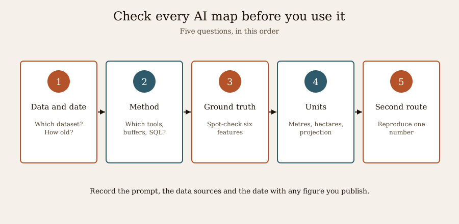
1. Which data, and how old? Ask the tool which dataset it used and its date. OpenStreetMap, census and business data can each be years apart.
2. Which method? Look at the steps, tools or SQL the platform shows. "Within 1 km" may be a straight-line buffer when you need walking or driving distance.
3. Spot-check on the ground. Pick three features the layer shows and three it should show; confirm them on imagery or on site.
4. Units and projections. Distances and areas computed in the wrong coordinate system can be badly off. Confirm metres, hectares and the map's projection.
5. A second route. Reproduce one key number another way, in QGIS or by hand. If the two disagree, find out why before you rely on either.
Record the prompt, the data sources and the date with any figure you publish. That is ordinary good practice in GIS, and more important when an AI chose the steps.
Privacy: where your site goes
Our own AI features in the Matrx Design Suite are built to run on your device, so your drawings stay in your browser. Cloud mapping platforms work differently, and that is not a criticism, just how they are built: your question, the site's location and any data you upload travel to the vendor's servers, and often on to the AI provider behind the assistant.
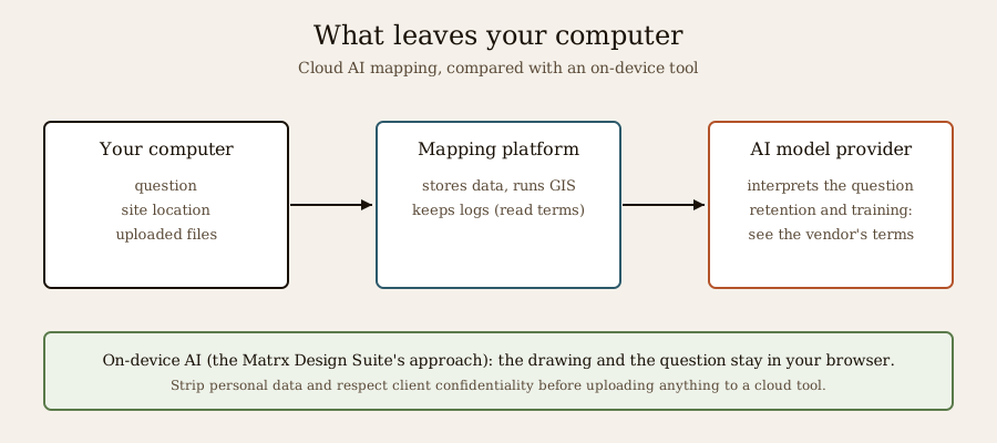
For most site studies that is acceptable, but think before uploading:
- Client confidentiality: an unannounced land purchase or a sensitive government site may be covered by a non-disclosure agreement.
- Personal data: owner names, phone numbers or survey data about people fall under India's Digital Personal Data Protection Act, 2023. Strip what you do not need.
- Retention and training: read whether the vendor keeps your prompts and data, and whether they are used to train models. Enterprise plans usually offer stronger terms.
Indian data: what to expect
Most of these platforms were built around rich data in the United States and Europe: parcel records, census tracts, zoning layers, business directories. India's equivalent data exists in pieces, held by different agencies, so out of the box you will usually get OpenStreetMap, satellite imagery and global datasets, and little parcel or zoning detail.
- Plot maps and master plans come from state land-records portals (many using the Bhunaksha system) and city development authorities. Upload them yourself where the licence allows.
- Regional base maps come from Survey of India's open series maps and ISRO's Bhuvan geoportal.
- Zoning and bye-law rules have to be read from the authority's documents; no AI tool knows your city's current regulations reliably, and only the authority's certificate settles a plot's zone.
Our guide on site analysis tools for architects lists the Indian data sources in more detail, and the free GIS for architecture, planning and urban design course and GIS for urban and regional planning teach how to work with them.
Where this is heading
Two trends are clear. First, mapping platforms are becoming tools that AI assistants call, through MCP and similar connections, rather than websites you visit. Second, the platforms that earn trust are the ones that show every step the AI took. The same shift is under way in engineering software: see how SDS2 2027 brings plain-language questions to steel models. For architects, the opportunity is less about replacing GIS skill and more about getting a first answer in minutes, then spending the saved time checking it properly and on design.
At Studio Matrx we are following the same direction in our own way: the free Matrx Design Suite will let you ask questions of your own drawing in plain words, answered on your device, with a future opt-in option for site context. For how AI is changing the rest of the design workflow, see AI architecture software.
Key takeaways
- Giraffe ties massing to feasibility numbers, with Claude as its AI interface; Felt makes easy team maps with an assistant and a free plan; CARTO runs agentic analytics on company data warehouses; Aino turns plain-language prompts into map layers; ArcGIS adds 100+ pretrained models and in-app assistants to the industry-standard GIS.
- The AI chooses the data and steps; the GIS still does the arithmetic. Errors come from the wrong dataset, an old date or a misread question, so look for tools that show their working.
- Check every AI map against its data date, method, a ground spot-check, units and a second route before using it.
- Cloud AI mapping sends your site and question to the vendor; mind client confidentiality and personal data.
- Indian plot and zoning data sits with states and cities; expect to bring your own.
References
1. Giraffe Knowledge Base — Welcome to Giraffe (AI interface uses Claude), 14 April 2026. intercom.help
2. Giraffe — AI agents in real estate (blog), 28 April 2026. website-jk2.pages.dev
3. AEC Magazine — Giraffe for urban planning. aecmag.com
4. Felt — Felt's new pricing, 13 October 2026. felt.com
5. Felt — Introducing the Felt MCP server, April 2026. felt.com
6. Felt — Raster analysis (blog) and Felt AI help centre. felt.com and help.felt.com
7. CARTO — What's new in CARTO, Q2 2026 (CARTO for Agents, AI Agents traceability), 8 July 2026. carto.com
8. CARTO — 5 geospatial AI breakthroughs from Google Next '26 (Site Selection Agent), 29 April 2026. carto.com
9. FlyPix — Aino tool review 2026, June 2026. flypix.ai
10. QGIS Python Plugins Repository — Aino QGIS plugin. plugins.qgis.org
11. Esri — Quick start guide to Esri pretrained GeoAI models (ArcNews). esri.com
12. Esri — What's new in AI assistants, June 2026 (ArcGIS Blog). esri.com
13. Esri — What's new in AI tools and models in ArcGIS, Q2 2026 (ArcGIS Blog). esri.com
14. Geospatial Training Services — Survey of AI tools across the ArcGIS platform, 2026. geospatialtraining.com
15. Esri Australia — AI in GIS: 5 takeaways from Esri UC 2026. esriaustralia.com.au
16. Government of India — Digital Personal Data Protection Act, 2023. meity.gov.in
Last verified 15 November 2026. AI features, plan limits and prices change often and several features are in preview; confirm current terms with each vendor. AI map output is a starting point, not evidence: verify data, method and results before using them in design, reports or approvals.
Export this guide
Related Guides — Deep-dive reading
Site Analysis Tools for Architects (2026): ArchiKEK, Forma, QGIS and What Works in India
From figure-ground maps to sun, wind and noise studies: what today's site-analysis tools actually do, which data exists for an Indian plot, and how to put a defensible site analysis together.
Design Software & ToolsHow to Choose a Security System (2026): The Master Buying Guide for Indian Homes and Buildings
The mental model that ties the whole buying decision together: start from your own risk, not a product; build the layers your situation actually needs; make the big architecture choices (wired vs wireless, local vs cloud, DIY vs professional); tell real product quality from marketing; and choose a vendor you can trust.
SecurityModel-Making for Architecture Students
The 2026 Working Reference for B.Arch Studios in India — Five Model Types, Scale-to-Material Map, Tool Kit, Indian Material Sources, Workshop Discipline (Including Laser-Cutter and 3D-Printer Access), Lighting and Photography for Jury Showings, Storage & Transport, Five-Year Skill Build, and Common Failure Modes
Student FoundationsRelated Tools — Try Free
Plot Buildability Report
How much can you build? FSI, ground coverage, setbacks and height → buildable footprint, built-up area, floors, parking and area statement, with a PDF.
Feasibility ToolApartment Video Door System Planner
Enter flats, entrances, floors and guard desk for a first-pass building intercom plan — door stations, indoor monitors, guard station, the right architecture and an indicative cost band.
Building PlannerCircadian Light Meter
Patient-centric circadian lighting visualizer for Indian healthcare design — time-of-day × intensity → CCT, melanopic lux (EML / mEDI), melatonin suppression, and an alertness curve. Calibrated against WELL v2 L03 Circadian Lighting Design, CIE S 026:2018, Brainard 2001, and Lucas et al. 2014.
Circadian Tool