
 Lesson 4.2
Lesson 4.2 · Density, Land Use & Form
Land Use & Mixed Use
What goes where, and why mixing beats sorting the city into zones
The city that undoes its own zoning
For most of the twentieth century, planners believed the humane thing to do was to sort the city like a filing cabinet: homes here, offices there, shops somewhere else, factories far away. It felt rational. It produced places you cannot live in without a car and streets that die at six in the evening. The great correction of our era is learning, again, to mix.
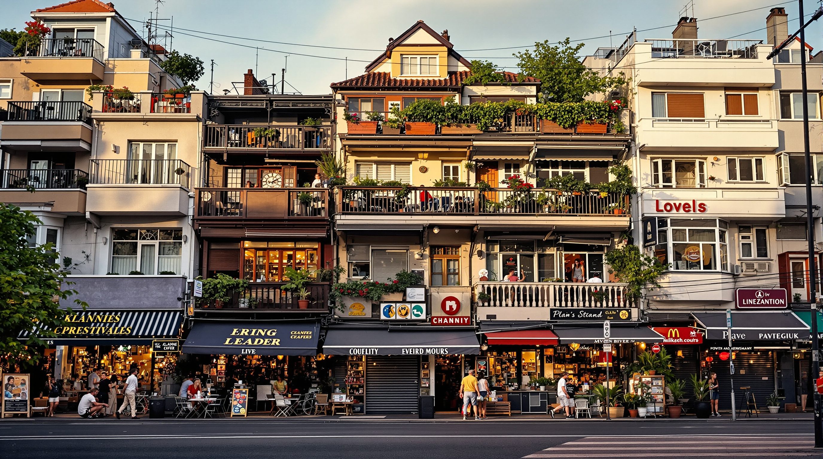
A street with twenty doors outlives a street with one gate. Grain is quiet resilience.
How the single-use city happened
Land-use segregation was not an accident; it was a reform. Early twentieth-century cities were genuinely grim in places, with tanneries and slaughterhouses cheek by jowl with tenements, smoke and effluent poisoning the poor who lived nearest the work. Zoning that separated 'noxious' industry from housing was, at first, a public-health triumph. The trouble was that the logic did not stop at genuinely incompatible uses. It hardened into a doctrine that all uses should be separated, so that shops, offices, homes and even different kinds of housing were sorted into their own exclusive districts and connected by roads. The most influential expression of this was Euclidean zoning in the United States, named after the 1926 Supreme Court case that upheld it, which arranged uses in a strict hierarchy and forbade mixing. Le Corbusier's Athens Charter of 1933 gave the doctrine its intellectual crown, declaring that the four functions of the city, dwelling, work, recreation and circulation, should each have their own zone. Chandigarh, planned on these principles, still reads as a diagram of separated sectors. The result everywhere was the same: a city that works only if everyone drives, because nothing you need daily is within walking distance of where you sleep. Understanding that segregation began as a well-meaning reform, and then over-reached catastrophically, is the key to arguing about it maturely rather than as caricature.
Jane Jacobs and the case for mixing
The most powerful answer to the single-use city came not from a planner but from a journalist and activist, Jane Jacobs, whose 1961 book The Death and Life of Great American Cities remains the field's founding polemic. Jacobs argued that a district's safety, vitality and economic health depend on diversity: a mix of uses that puts different people on the street at different hours. Her four generators of diversity are worth memorising because they still work as a design checklist. First, a district must serve more than one primary function, so that people are present across the day and evening, not just at nine and five. Second, blocks must be short, so that streets connect and footfall spreads rather than being funnelled. Third, buildings must vary in age and condition, because new construction alone yields only high rents, and it is the older, cheaper stock that shelters the bookshop, the studio and the start-up. Fourth, density must be sufficiently high to sustain all this activity. Together these produce what she called the intricate, self-organising 'sidewalk ballet' of a living neighbourhood. Crucially, Jacobs was describing exactly the qualities that single-use zoning destroys, and exactly the qualities that traditional Indian bazaar streets, a Chandni Chowk or a Pune peth, possess in abundance: shops below, homes above, workshops behind, all on a fine-grained street where something is always open. The lesson of the correction is that mixing is not a stylistic preference; it is the mechanism that makes a neighbourhood work.
Vertical and horizontal mixing
Mixed use comes in two geometries, and a good neighbourhood usually needs both. Vertical mixing stacks different uses in the same building: the classic shop-house, with a shop or workshop at street level and dwellings on the floors above, or the contemporary version with retail on the ground floor, offices on the mezzanine and apartments above. It is intensely efficient, keeps eyes on the street, and lets someone live above their livelihood, an arrangement Indian cities have practised for centuries in every bazaar and main-road frontage. Horizontal mixing distributes different uses across adjacent plots and blocks: a residential street with a corner shop, a school two blocks away, a clinic around the corner, a small park at the end. Neither alone is sufficient. A district that is only vertically mixed on one high street, with monofunctional housing behind, still leaves most residents far from daily needs; a district that is only horizontally mixed, with strict single-use plots, misses the efficiency and street life of the shop-house. The design skill is to compose the two: an active, vertically mixed frontage on the main streets and around nodes, with a fine horizontal mix of local uses, shops, schools, workplaces, threaded through the residential fabric behind. The figure contrasts the sorted single-use diagram with a genuinely mixed neighbourhood so you can see how differently the two distribute daily life.
Fine grain versus coarse grain
Beyond the mix of uses lies a subtler and equally decisive quality: grain, the size of the individual pieces that make up the urban fabric. A fine-grained street is made of many small plots and many doors: twenty narrow shopfronts in a hundred metres, each a different owner, trade and rhythm. A coarse-grained street is made of a few large plots: one supermarket, one mall, one gated complex occupying the same hundred metres behind a single blank frontage and one entrance. Fine grain is what makes a street feel alive and resilient, because variety, competition, affordability and constant change are built into its very geometry; when one small business fails, a single unit turns over, not a whole block. Coarse grain concentrates control, kills the small operator, and produces long dead frontages, the blank service wall of the mall, the compound wall of the enclave, that starve the footpath of interest and eyes. India's traditional bazaars are among the finest-grained fabrics on earth, which is precisely why they remain so vital even as glossy malls struggle. The danger in contemporary Indian redevelopment is the relentless coarsening of grain: many small plots amalgamated into one large gated tower complex, replacing dozens of active doors with a single guarded gate and a blank wall. A crucial and often invisible job of good land-use planning is therefore to protect fine grain, through plot-size limits, frontage rules and active-frontage requirements, not just to specify which uses are allowed.
The 15-minute city
The most influential contemporary packaging of all these ideas is the '15-minute city', articulated by Carlos Moreno and adopted vividly by Paris under Mayor Anne Hidalgo. The proposition is disarmingly simple: every resident should be able to meet most daily needs, work, groceries, education, healthcare, culture and green space, within a fifteen-minute walk or cycle of home. It is, in effect, Jacobs' diversity and the complete neighbourhood re-expressed as a public-facing target that ordinary citizens and mayors can grasp and demand. Its power is political as much as technical: it turns an abstract argument about land use into a concrete promise about time and everyday freedom. It also reframes the goal. Rather than moving people faster across a segregated city, it brings destinations closer, so the best trip becomes the one you no longer need to take by car. For India the idea is at once familiar and challenging: the traditional Indian mohalla or the mixed main-road neighbourhood already delivers a version of the 15-minute city, often a 5-minute one, while new car-oriented townships and gated enclaves on city edges pointedly do not. The critique to hold in mind is that proximity alone is not enough, the destinations must be genuinely accessible and affordable, not merely nearby, and that the concept must not become an excuse to neglect the citywide networks and jobs that no single neighbourhood can contain. Used well, though, it is the clearest brief an urban designer can be handed: put daily life within a walk.
Land use in the Indian plan
In Indian practice, land use is fixed most formally in the Master Plan or Development Plan, which carries a colour-coded land-use map, residential in yellow, commercial in blue, industrial in purple, and so on by convention, backed by a land-use zoning table specifying what is permitted, permissible with permission, and prohibited in each zone. The URDPFI Guidelines provide the national template for these categories and for the proportions a balanced city should aim at. The historical problem is that many Indian plans inherited the single-use instinct, drawing large exclusive residential zones and separate commercial districts, even though Indian urban life has always been intensely mixed. The gap between the plan and the lived reality is why so much genuinely useful activity, the tailor working from home, the tuition class, the corner provision store, technically breaches the sanctioned use and survives only through informality or periodic regularisation. The reformist direction, visible in newer development control regulations and in TOD and mixed-use overlays, is to legalise and encourage mixing rather than fight it: permitting shops on residential streets up to a size threshold, allowing homes above commercial frontages, and defining genuine mixed-use zones. The professional lesson is to read the land-use plan not as a fixed truth but as a policy instrument that can, and increasingly should, be written to permit the fine-grained mix that Indian cities do naturally and that single-use zoning criminalised. Always, of course, verify the current sanctioned land use and permissions with the local development authority before advising a client.
Designing the complete neighbourhood
Pull the threads together and a clear design target emerges: the complete neighbourhood, a walkable area that mixes uses, varies its grain, and puts the ingredients of daily life within a short walk of every home, supported by enough density to sustain them and enough transit to connect them to the wider city. This is not nostalgia for the pre-modern town; it is the deliberate reassembly, on contemporary terms, of what segregated zoning took apart. It asks the designer to think in terms of a daily catchment: draw a five- and fifteen-minute walking radius around a home and audit what actually falls inside it, a shop, a school, a clinic, a park, a workplace, a bus stop, and design to fill the gaps. It asks for active frontages on the streets that carry the most life, and for protection of the small plot and the small business against the coarsening pressure of amalgamation. And it asks for humility about the limits of any one neighbourhood: mixing serves daily needs, but a city still needs its specialised districts, its regional hospitals, its universities, its industrial areas, connected by the networks of the previous module. The mature position is neither rigid segregation nor a fantasy that every need can be met next door, but a layered city: intensely mixed and fine-grained at the neighbourhood scale, sensibly specialised and well connected at the metropolitan one.
URDPFI Guidelines (TCPO, MoHUA)
National template for land-use categories, colour conventions and the zoning table in Indian development plans
Increasingly supports mixed-use categories; use as the reference framework and confirm the sanctioned local plan.
Master Plan / Development Plan land-use map & zoning table
Statutory allocation of permitted, permissible and prohibited uses by zone in a city
The legal instrument that fixes land use; verify the current sanctioned plan and any mixed-use or TOD overlays with the development authority.
Mixed-use / TOD overlays in DCR / DCPR
Provisions permitting mixing of uses, especially along transit corridors and main streets
Newer regulations legalise shops on residential streets and homes above commercial frontages up to defined thresholds.
74th Constitutional Amendment / ULB planning powers
Devolution of urban planning to local bodies, enabling locally responsive land-use decisions
Empowers city and ward-level plans that can better reflect India's naturally mixed urban life.
Audit a 15-minute neighbourhood
Test whether a real neighbourhood delivers daily life within a walk, and design the fixes.
Base map or OpenStreetMap, coloured pens, tracing paper; optional QGIS for isochrones
Pick a home you know and get a map of the surrounding area, on paper or in OpenStreetMap.
- 1Draw a 5-minute (about 400 m) and a 15-minute (about 1.2 km) walking radius around the home, following actual walkable routes, not straight lines.
- 2Mark every daily-need destination that genuinely falls inside each radius: grocery, school, clinic, park, workplace, transit stop, place of worship.
- 3List the gaps, the needs that force a vehicle trip, and note whether the barrier is distance, a missing use, or a broken walking connection.
- 4Propose three land-use or grain interventions, for example permitting a corner shop, adding active frontage, or subdividing a coarse plot, that would close the biggest gaps.
You’ll walk away with
An annotated catchment map with a short memo listing the gaps and three prioritised interventions to make the neighbourhood more complete.
Three altitudes on the same idea
Read the band that fits you — or all three.
Treat the ground floor as the neighbourhood's most valuable real estate and design it to hold active uses, shops, workshops, entrances, even when the brief says 'residential'. Argue for the flexible floor-to-floor heights and separate street entrances that let a building change use over its life, because the building you design will outlive the use it was built for. A blank compound wall or dead podium is a hundred metres of neighbourhood you have quietly killed.
As the urban designer, you decide the mix and the grain. Write land-use rules that permit and encourage vertical and horizontal mixing rather than criminalising it, and protect fine grain with plot-size limits and active-frontage requirements, not just use lists. Design to the daily catchment: audit what falls within a five- and fifteen-minute walk of each home and compose the plan to fill the gaps while keeping the citywide networks and specialised districts intact.
The core idea is simple: a good neighbourhood mixes what a segregated city sorts, so daily life fits inside a short walk. Test it by walking your own area with a stopwatch, marking everything you can reach on foot in fifteen minutes, then noticing what forces you into a vehicle. Learn to read a Master Plan's land-use map and its zoning table; they tell you what the city is officially allowed to be.
“Separating homes from shops and workplaces makes neighbourhoods quieter and more pleasant to live in.”
Do it yourself
Quick checks before you move on.
- 1State Jane Jacobs' four generators of diversity from memory.
- 2Give one example each of vertical and horizontal mixed use from a place you know.
- 3Explain why fine grain makes a street more resilient than coarse grain.
Pulling it together
Peer-reviewed journals & authoritative standards
- 01Jane Jacobs, The Death and Life of Great American Cities — Routledge (reprint of the 1961 classic), 1961.
- 02Town and Country Planning Organisation, URDPFI Guidelines (land-use classification) — TCPO, Ministry of Housing and Urban Affairs, 2015.
- 03UN-Habitat, guidance on mixed use and the compact, connected, inclusive city — UN-Habitat, 2020.
- 04American Planning Association, resources on mixed-use zoning and complete neighbourhoods — American Planning Association, 2021.
If mixing is the goal, how does a city actually regulate what gets built where? Next we examine zoning and development control, the legal machinery, and its critics.
The author
Amogh N P
Architect, interior designer, and creative polymath. Studio Matrx began in his notebooks — his vision of design made honest, useful, and open to everyone. Its Academy is written and taught in his memory, and free, forever.
More about Amogh →