
 Lesson 3.3
Lesson 3.3 · Streets, Movement & Networks
Connectivity & Street Networks
How block size, intersections and permeability shape the whole city
The pattern is the city
You can perfect a single street and still trap a neighbourhood, because how streets connect matters more than how any one of them looks. The network decides whether a walk is short and direct or long and defeating, whether traffic disperses or chokes one artery, whether a place is legible or a maze. Learn to read the pattern and you learn to read the city.
Every gate is a minus sign on the city's map. Count them and you can feel the traffic thicken.
Why the network beats the street
The previous two lessons perfected the individual street. Now zoom out, because a city is not a collection of streets but a network of them, and the network has properties no single street possesses. Connectivity is the degree to which streets link to one another, offering many routes between any two points. A highly connected network, like a grid, disperses traffic across many parallel paths and gives a walker short, direct options. A poorly connected network, like a tree of cul-de-sacs feeding one collector road, forces every trip, whether by foot or car, onto a few overloaded channels and lengthens every journey. The same footpath is worth far more in a connected network than in a disconnected one, because in the first it is a link in a web of choices and in the second it is a dead-end. This is why network design is arguably the single most consequential decision in laying out a new area: streets are nearly permanent, far more durable than the buildings along them, so the pattern you draw will outlive everything and shape movement for centuries. Get the network wrong and no amount of good street design later can fully rescue it.
Block size: the master dial
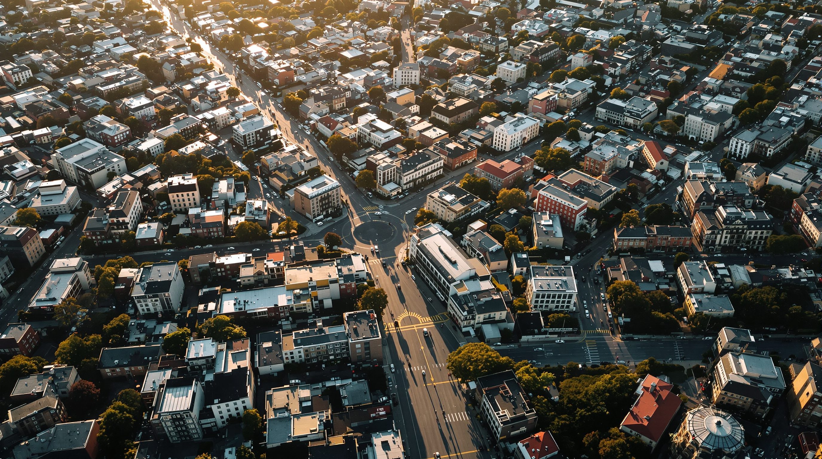
The block is the fundamental unit of urban form, and its size is the dial that controls almost everything else. Small blocks mean frequent intersections, many route choices, short walking detours and abundant corners, which are the most valuable retail and social locations in any city. Large blocks mean the opposite: fewer choices, long detours, blank mid-block frontages and superblocks that pedestrians must skirt. Jane Jacobs devoted a chapter of her great book to the need for short blocks precisely because they multiply the paths through a district and mix its foot traffic. Compare Barcelona's Eixample, Ildefons Cerda's nineteenth-century grid of roughly 113-metre blocks with their famous chamfered corners, which produces a superbly permeable and lively fabric, against the vast introverted superblocks of many late-twentieth-century layouts, where a single block can be half a kilometre across. Traditional Indian settlements, from the pols of Ahmedabad to the mohallas of old Delhi, are built of very fine grain with tiny blocks and countless lanes, an intensely walkable pattern that modern layouts often abandoned in favour of large plots and wide roads. As a rule of thumb, perimeter block lengths of roughly 70 to 150 metres keep a network walkable; much beyond that and the pedestrian starts paying a detour tax, because the walk from one side to the far corner grows faster than the block's area suggests. Corners are where the value concentrates too: a fabric of small blocks generates many more corner plots, the prime locations for shops, cafes and the incidental encounters that make a street feel alive. The figure contrasts fine and coarse grain.
Intersection density and the metrics of connectivity
Connectivity can be measured, and the measures guide design. Intersection density, the number of street intersections per square kilometre, is among the most reliable predictors of walking and cycling; more intersections mean smaller blocks and more route choices. The link-to-node ratio compares the number of street segments to the number of intersections; higher values indicate a more connected, grid-like network, while a pure tree of cul-de-sacs approaches the low end. Route directness, sometimes called the detour or circuity ratio, compares the actual network distance between two points to the straight-line distance; a value near one means you can walk almost directly, while high values mean the network forces long loops. These are not academic abstractions. When a city assesses a proposed layout, it can compute these metrics from the plan and predict, before a brick is laid, whether the area will be walkable or car-dependent. Open data and tools make this easy: you can pull any city's streets from OpenStreetMap into QGIS and calculate intersection density across a whole metropolis, revealing at a glance which districts are permeable and which are sealed. The lesson for the designer is to treat connectivity as a measurable performance target, not a matter of taste.
Grid versus cul-de-sac
The twentieth century staged a long argument between the grid and the cul-de-sac, and understanding it clarifies the trade-offs. The grid, humanity's oldest planning device from Mohenjo-daro to Manhattan, offers maximum connectivity, easy wayfinding, resilient distribution of traffic and endless corner sites. Its critics charged it with monotony and with letting through-traffic invade quiet areas. The cul-de-sac, championed in the Radburn layout of 1929 and then mass-produced in suburbs worldwide, promised quiet, safe, traffic-free enclaves by deliberately breaking connectivity. The cost, invisible at first, was devastating for anything but the private car: distances balloon, walking becomes impractical, buses cannot serve looping dead-ends, and all traffic piles onto a few collector roads that then must be widened, feeding the very congestion the layout was meant to escape. The New Urbanists, through the Congress for the New Urbanism, mounted a sustained revival of the connected, walkable grid as the antidote. The mature position is not grid-fundamentalism: a 'fused grid' or a modified grid can calm interiors while preserving connectivity, and a few short cul-de-sacs linked by pedestrian and cycle paths can offer quiet without sealing the network. The figure compares the movement logic of the two extremes.
Permeability and the gated city
Permeability, the ease of moving through an area by many routes, is connectivity experienced at human scale, and India is currently making a historic bet against it. The traditional Indian city was extraordinarily permeable, a dense mesh of lanes anyone could thread. The contemporary Indian city, by contrast, is privatising its street network at speed through gated communities and walled enclaves that take large parcels off the public grid, forcing everyone outside to detour around superblocks that may span hundreds of metres of blank compound wall. Each gate is a subtraction from the collective network, and their accumulation quietly grinds the whole city's movement to a crawl while destroying the eyes-on-the-street that make public space safe. Chandigarh, Le Corbusier's planned city, offers a subtler cautionary tale: its rational hierarchy of sectors, each a large superblock ringed by fast roads, is orderly and green but coarse-grained, and the long distances and inward-facing sectors make it far more car-oriented than the fine-grained Indian towns it replaced as a model. The design imperative is to keep the public network continuous: cap block sizes, require through-connections for pedestrians and cyclists even where vehicular gating is allowed, and resist the enclosure of streets that belong to everyone. Permeability, once lost, is almost impossible to recover.
Space syntax and the logic of movement
How do you predict, from a plan alone, where people and life will concentrate? Space syntax, developed by Bill Hillier and colleagues at University College London, offers a rigorous method. It models the street network as a set of lines of sight and movement and computes each street's 'integration', roughly how central and accessible it is within the whole network. The striking finding, confirmed across many cities, is that the most integrated streets attract the most pedestrian and vehicular movement simply by virtue of their position in the network, a phenomenon Hillier called 'natural movement'. Retail, density and life then cluster on these naturally busy streets, which is why the main bazaar sits where it does, often without anyone having planned it there. Space syntax explains why a beautifully designed street in a poorly integrated location stays empty while a plain one on an integrated spine thrives, and it lets designers test, before building, whether a proposed layout will produce a legible, well-used centre or a diffuse, lifeless sprawl. Kevin Lynch approached the same question from perception in The Image of the City, showing how paths, edges, districts, nodes and landmarks let people build a mental map; a well-connected, legible network is one people can hold in their heads and move through with confidence.
Figure-ground, hierarchy and drawing a new network
Two practical skills close the loop between analysis and design. The first is reading the figure-ground plan, the black-and-white drawing that shows building mass as solid and public space as void, a technique Colin Rowe made famous in Collage City. A figure-ground of Rome's dense fabric versus a modernist estate reveals in one glance whether the public realm is a shaped, continuous outdoor room or a leftover between free-standing towers; it is the fastest way to diagnose the character of a network and its blocks. The second skill is composing a hierarchy when you draw a new network. A healthy hierarchy runs from arterials that carry longer trips, through collectors that gather local movement, down to access lanes at the finest grain, with each tier connected so that no level is forced to do another's job, the failure mode of the cul-de-sac layout where access lanes dump straight onto arterials. The art is to grade the hierarchy without breaking connectivity: even the quietest lane should offer a through-route for someone on foot or a bicycle. When you lay out a greenfield extension or a redevelopment, draw the network first and the plots second, size the blocks against your walkability targets, place the integrated spine where you want the centre to grow, and only then let the buildings fill in. The pattern you commit to paper will outlast everyone who argued over it.
URDPFI Guidelines (layout & road hierarchy)
Indian norms for road hierarchy, plotting and layout planning
Reference for network structure in new area plans; push for smaller blocks and higher connectivity than the minimums allow.
Congress for the New Urbanism principles
Connected, walkable, fine-grained network design
Codifies the case for short blocks and connected grids; a useful counter to cul-de-sac defaults.
Space Syntax methodology
Analytical modelling of network integration and movement
Use to test a proposed layout's connectivity and predict where movement and centres will form.
OpenStreetMap + QGIS workflows
Open data and tools for measuring intersection density and directness
Let any planner audit a real network's connectivity at city scale; verify data currency for the study area.
Read two networks
Compare a fine-grained traditional quarter with a modern gated or cul-de-sac layout in the same city and quantify the difference.
QGIS + OpenStreetMap, or printed maps and tracing paper; a ruler and calculator
Choose two one-kilometre-square areas: one old and organic, one modern and enclave-based.
- 1Trace or export the street network of each area (OpenStreetMap into QGIS, or hand-trace from a map).
- 2Count intersections in each square to compute intersection density, and estimate average block size.
- 3Pick two everyday origin-destination pairs in each and compare network distance to straight-line distance to get a detour ratio.
- 4Write a short verdict on which network serves walking, cycling and transit better, and why, with your numbers as evidence.
You’ll walk away with
Two annotated network diagrams with intersection density, block size and detour-ratio figures, plus a one-paragraph verdict.
Three altitudes on the same idea
Read the band that fits you — or all three.
Your site sits inside a network you did not draw, so read it first. On a large plot, resist the temptation to gate and superblock it; break it with through-streets and public passages that extend the surrounding grid, and put your active uses and entrances on the most integrated edges where movement naturally concentrates. A permeable site is worth more, commercially and civically, than a sealed one.
As the urban designer the network is your primary instrument. Set block sizes and intersection density as explicit performance targets, keep detour ratios low, and treat every gated enclave as a subtraction from the public grid to be resisted or at least pierced with pedestrian through-links. Use space syntax and OSM-based metrics to test a layout's connectivity before it is built, not after.
Learn to read figure-ground and network plans. Trace the streets of a fine-grained old quarter and a gated suburb, count the intersections in each, and feel the difference in route choice. Pull a city into QGIS from OpenStreetMap and map intersection density. Once you can see the pattern, you can never unsee its effects on how a place lives.
“Cul-de-sac and gated layouts are safer and quieter, so they are better urban design.”
Do it yourself
Check your grasp.
- 1Explain why a good footpath is worth more in a grid than in a cul-de-sac layout.
- 2Give an approximate walkable range for perimeter block length and say what happens beyond it.
- 3Define intersection density and detour ratio and state which direction each should move for walkability.
Pulling it together
Peer-reviewed journals & authoritative standards
- 01Space Syntax, Natural Movement and Network Integration — Space Syntax, 2020.
- 02Lynch, The Image of the City — MIT Press, 1960.
- 03Congress for the New Urbanism, Connected Street Networks — Congress for the New Urbanism, 2020.
- 04OpenStreetMap, street network data — OpenStreetMap Foundation, 2024.
A connected network is what lets buses and trains reach people efficiently; the final lesson of the module puts the network to work through transit and the wider system of urban mobility.
The author
Amogh N P
Architect, interior designer, and creative polymath. Studio Matrx began in his notebooks — his vision of design made honest, useful, and open to everyone. Its Academy is written and taught in his memory, and free, forever.
More about Amogh →