
Cluster Housing Explained
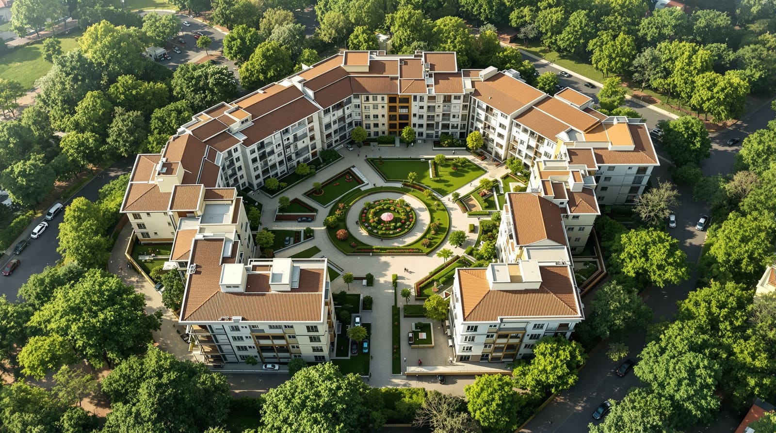
Grouping homes around a shared court instead of road-facing plots — the cluster as a planning unit, low-rise high-density, more usable open space, and the Aranya Indore lesson
In a row-house scheme on the edge of Indore, twelve families share a single rule that has quietly reorganised their lives: no car comes past the gate. The vehicles sit in a small bay where the access lane meets the main road. Beyond that bay, the ground belongs to people. A shaded court no bigger than a tennis double opens between the homes, and on a June evening before the monsoon breaks it is full — children chasing each other around a single neem tree, two grandmothers on a low plinth, a delivery rider walking the last thirty metres on foot because there is nowhere to ride. None of these homes is large. None faces a wide road. Each one borrows generosity from the shared middle.
A few kilometres away, in a more conventional plotted colony, the same number of families occupy the same number of square metres of land — but each plot fronts a road, each compound wall pushes the next house away, and the only open space is the strip of tarmac the cars need. The two layouts hold roughly the same people on roughly the same land. They feel like different worlds. Cluster housing is the typology that produces the first world: a planning unit in which a small group of homes is gathered tightly around a shared open space, and the land saved from roads and setbacks is pooled into a court that everyone uses.
The cluster as the unit of planning
Most Indian residential development is conceived one plot at a time. The municipality cuts a grid of roads, the developer subdivides the land into rectangles, and each rectangle is sold and built independently. The plot is the unit. Cluster housing inverts this. Here the unit of planning is not the single plot but the group — typically six to twenty homes — arranged around a shared court or green, reached by a short access lane rather than a road frontage for each dwelling.
The arithmetic is the quiet revolution. In a plotted layout, a large share of the land is consumed by the roads that must touch every plot and by the side-and-rear setbacks each house leaves around itself. Cluster housing trims both. The homes sit closer together, sharing party walls or narrow gaps; the cars are parked once, at the edge, instead of being driven to every door; and the land thus recovered is not scattered as useless slivers but consolidated into a single, usable common open space. The same families, the same plot ratio — but the leftover land is gathered into a place instead of dispersed into margins.
This is a different concern from the step-by-step mechanics of subdividing land, road widths and plot sizes covered in how to design a residential layout. Cluster housing is the shape the layout takes once you decide the group, not the individual plot, is what you are designing.

A long lineage, Indian and global
The cluster is not a modern invention; it is one of the oldest ways humans have organised dwelling. The traditional Indian courtyard settlement — the cluster of houses opening onto a shared chowk or otla in a Rajasthani or Gujarati town, the agraharam row, the wada in Maharashtra — is cluster housing in its vernacular form: homes turned inward to a common, shaded, social ground, with the street kept narrow and the heat kept out.
The twentieth century rediscovered the idea and gave it new names. The Radburn plan in 1920s New Jersey introduced the superblock — homes grouped so that pedestrians and cars never crossed, with houses facing onto interior greens and garages turned to the service lane behind. Postwar British and Scandinavian housing refined low-rise courtyard and row schemes into a fine art. And in India, B. V. Doshi's Aranya township at Indore, designed in the 1980s, remains the canonical demonstration: a site-and-services scheme of tightly clustered low-rise plots around intimate courts and pedestrian lanes, designed so that families across income levels could build incrementally yet still share genuine common space. Aranya won the Aga Khan Award and is still studied precisely because it proved a cluster could be affordable, high-density and humane at once. These threads — the courtyard, the superblock, the incremental cluster — are the inheritance every Indian cluster scheme draws on.
What clustering buys you
The benefits follow directly from the geometry, and they are worth stating plainly rather than romantically.
More usable open space. Because roads and setbacks shrink, the recovered land becomes a real court — large enough for play, for trees, for sitting — rather than the ornamental green strip that gated layouts so often reduce open space to. This connects closely to the discipline of open-space planning for residential layouts: a cluster makes open space the centre, not the leftover.
A safe, car-free core. With parking pushed to the cluster edge, the heart of the cluster has no through traffic. Children can be let out of the door. This is the same logic explored at neighbourhood scale in car-free neighbourhood design, but the cluster delivers it at the most intimate scale — the dozen homes a parent can actually keep an eye on.
Community by adjacency. A shared court with a single entry produces casual, repeated, low-stakes encounter — the precondition for the kind of community that gated towers, with their lobbies and lifts, rarely generate.
Efficient services and shorter roads. Shorter access lanes mean less paving, less drainage to build and maintain, shorter water and sewer runs. The infrastructure cost per home falls — a meaningful number for affordable housing.
Privacy through clever grouping, not distance. Counter-intuitively, well-designed clusters can give more privacy than dispersed plots, by staggering entrances, layering the route from public lane to semi-private court to private home, and orienting windows away from each other.
The design moves that make a cluster work
A cluster is not simply houses packed closer; it is a small choreography of public and private. A handful of moves recur in every good example.
Cluster geometry. The homes are arranged to define the court — in a U, an L, a loose square or a short double row — so that the open space is enclosed and legible, not the gap between two buildings.
The shared court at the centre. This is the cluster's reason for being: a paved or planted common, scaled for the number of homes, ideally shaded against the Indian sun and able to drain in the monsoon.
Parking at the edge. Vehicles are gathered in a bay or pocket where the access lane meets the larger road, so the core stays car-free. People walk the last short distance.
The pedestrian core. The court connects to the homes by foot — thresholds, plinths, verandahs — so the route from car to door is itself a social space.
Layering privacy. The sequence public lane → shared court → home threshold → private interior is graded carefully, so that openness at the centre never costs the household its retreat.
Density without the high-rise
The most important thing cluster housing demonstrates is that density and low-rise are not opposites. India's default response to land scarcity is the tower; the cluster offers another answer — low-rise, high-density. By trimming roads and setbacks and sharing walls, two- and three-storey homes can reach densities that people assume require lifts and towers, while keeping every home close to the ground and to a usable court. Aranya did exactly this. The broader logic — how many homes a hectare can humanely hold and by what means — is the subject of residential density planning; the cluster is one of its most powerful instruments.

Dispersed plots versus clustered housing
The contrast is sharpest seen side by side. The two layouts can hold the same families on the same land — what differs is where the leftover land goes and how it feels to live there.
| Aspect | Dispersed road-facing plots | Clustered housing |
|---|---|---|
| Unit of planning | The individual plot | The group of 6–20 homes |
| Access | Every plot fronts a road | Short shared access lane & edge parking |
| Open space | Scattered slivers, setbacks & verges | Pooled into a usable shared court |
| Cars | Driven to every door | Parked once at the cluster edge |
| Road & service length | Long; high infrastructure cost | Short; lower cost per home |
| Child safety | Streets carry traffic to each door | Car-free pedestrian core |
| Community | Incidental, fence to fence | Built in by the shared court |
| Privacy | By distance & compound walls | By layering & clever grouping |
| Density achievable | Limited without going high-rise | Low-rise high-density possible |

How clusters become a neighbourhood
A single cluster of a dozen homes is not a settlement. The typology scales by aggregation: clusters are repeated and linked, court to court, by pedestrian greens and lanes, so that a child can walk from one shared core to the next without crossing a busy road, and the small commons of each cluster string together into the larger open-space network of the neighbourhood. Vehicle access feeds the cluster edges from a clear road hierarchy, while the pedestrian realm runs continuously through the middles. Done well, the aggregation produces exactly the qualities that define a good place — the walkable, legible, sociable settlement described in the anatomy of a good neighbourhood — but assembled from the bottom up, one humane cluster at a time, all the way up to the scale of the future Indian township.

Does it work in India — and how to make it real
The honest answer is that cluster housing works in India, and we have proof — but it runs against the grain of how Indian land is sold and governed, and that is the real obstacle, not the design.
The first difficulty is the plotted-development default. Municipal byelaws, valuation, and buyer expectation are all built around the individually owned, road-facing plot with its prescribed setbacks. A plot that opens onto a shared court rather than a public road can be harder to mortgage, to value, and to approve, because the rules assume the plot, not the cluster, is the unit. Realising clusters at scale often needs an enabling framework — group-housing or layout regulations, or a public agency willing to plan and service the cluster — rather than a market that subdivides plot by plot, as described in residential plot distribution. The cluster is the deliberate alternative to that plot-by-plot default, and the contrast is the whole point.
The second is affordability, and here the cluster is an ally, not an obstacle. Shorter roads and shared services lower the cost per home; Aranya was conceived precisely as affordable housing, and its incremental, build-as-you-can clusters are still the exemplar for delivering dignity at low cost. A cluster lets a modest home borrow grandeur from a shared court it could never afford alone.
The third is governance — the maintenance reality. A shared court is only an asset if someone keeps it. Clusters need a clear, modest agreement on who sweeps, plants, drains and pays — a small resident body, kept deliberately simple. This is where the cluster meets the social models that animate it: the spatial typology of homes-around-a-court is the physical form that community-centric housing and co-housing models so often take. Those guides describe the social and ownership arrangements; the cluster is the shape they live in. (It should not be confused with the rural cluster village development, which works at a different scale and economy — the village habitat, not the urban court.)
The fourth is climate. The Indian court is not a temperate one. It must be shaded against the summer, oriented for breeze, and — crucially — able to take the monsoon: a court that floods or grows malarial is worse than no court. The shared green is also the obvious place to hold and soak rainwater, linking the cluster to water-sensitive urban design. Designed for the Indian sky, the court earns its keep three seasons over.
The cluster, in the end, is a small act of trust made physical — twelve families betting that a shared middle is worth more than twelve private margins. The evidence from Indore says the bet pays. If you are imagining a community organised this way and want to test how the homes, the court and the lane fit together before a single wall is built, DesignAI can help you visualise the cluster and its shared heart.
References
1. Vastu Shilpa Foundation / B. V. Doshi, Aranya Community Housing, Indore — Aga Khan Award for Architecture (1995) project documentation.
2. Clarence Stein & Henry Wright, Toward New Towns for America — the Radburn superblock and the separation of pedestrian and vehicular realms.
3. URDPFI Guidelines 2014 (Ministry of Urban Development, Government of India) — norms for group housing, cluster planning, open space and densities.
4. Christopher Alexander et al., A Pattern Language — patterns on house clusters, common land and the degrees of privacy.
5. Jan Gehl, Cities for People (Island Press, 2010) — the human scale, life between buildings and the case for the low-rise pedestrian realm.
6. National Building Code of India 2016 (Bureau of Indian Standards) — provisions relevant to group housing layouts, access and open space.
Read this alongside community-centric housing and co-housing models — the social models that the cluster gives spatial form — and plan your own with DesignAI.
Export this guide
Related Guides — Deep-dive reading
Belapur Incremental Housing: How Charles Correa Gave the Poor a House That Could Grow
In Navi Mumbai, Charles Correa refused the housing block. Instead he gave roughly 550 families a small plot, an open-to-sky courtyard, and — crucially — no shared walls, so each house could be extended by its own occupants over decades. It is India's most quietly radical answer to where affordable housing should go next.
The Future of ArchitectureAranya Low-Cost Housing: How B.V. Doshi Let a City Build Itself
In Indore, B.V. Doshi and the Vastu-Shilpa Foundation gave 6,500 low-income families a serviced plot and a small core — a plinth, a service wall, one room and a toilet — then handed them the pencil. A case study in incremental, site-and-services housing, the Aga Khan Award it won, and the honest question of who actually got to live there.
The Future of ArchitectureSequential Progressions: Why the Order of Spaces Matters
A home is experienced as a journey in time, not a plan seen all at once — and arranging that journey, with compression, release and thresholds from public street to private inner room, is what makes a house feel right.
Design PrinciplesRelated Tools — Try Free
Rainwater Tank Sizer
How big should your rainwater tank be? Computes annual harvest, recommended tank capacity in litres, water-bill savings, and payback — for 10 Indian cities.
RWH CalculatorCross-Ventilation Analyzer
Estimate airflow and air changes per hour (ACH) from room size, window areas, layout, and local wind — with NBC 2016 Part 8 compliance check.
Ventilation CalculatorInterior Layout Planner — Printable Graph Grid
Printable graph grid to sketch room layouts to scale before committing to furniture placement.
Layout Tool