
Cluster Village Development
Grouping homesteads and whole villages to share what scattered settlements cannot afford — compact clustering vs dispersal, the SPMRM Rurban model, and the economics of shared rural infrastructure
In a tehsil somewhere between the highway and the hills, five small hamlets sit within a few kilometres of one another. Each has perhaps forty households, a hand pump or two, a single-room school that opens when a teacher can be found, and a kachcha track that turns to mud in July. None of them has a doctor. None has a cold store, so the milk and the tomatoes are sold at whatever the morning trader offers. When a child needs a real classroom or a woman needs a delivery bed, the family walks or borrows a motorcycle to the next big village — the one with the weekly haat, the pucca road and the bus that actually comes. That bigger village does not have these things because it is special. It has them because enough people, close enough together, made them worth building.
This is the quiet logic that scattered settlement defeats. A health centre needs a catchment; a good school needs enough children; a processing unit needs enough produce; a paved road and a piped-water scheme cost roughly the same length whether they serve ten houses or fifty. When homes and hamlets are spread thin across the fields, every service runs longer, costs more per family and reaches fewer of them — so it is never built at all. Clustering is the deliberate act of bringing homes, or whole villages, close enough together that the things none could afford alone suddenly become affordable for all of them.
Two senses of one idea
"Cluster" gets used at two very different scales in rural India, and confusing them is the commonest mistake. This guide keeps them distinct because the design moves are different.
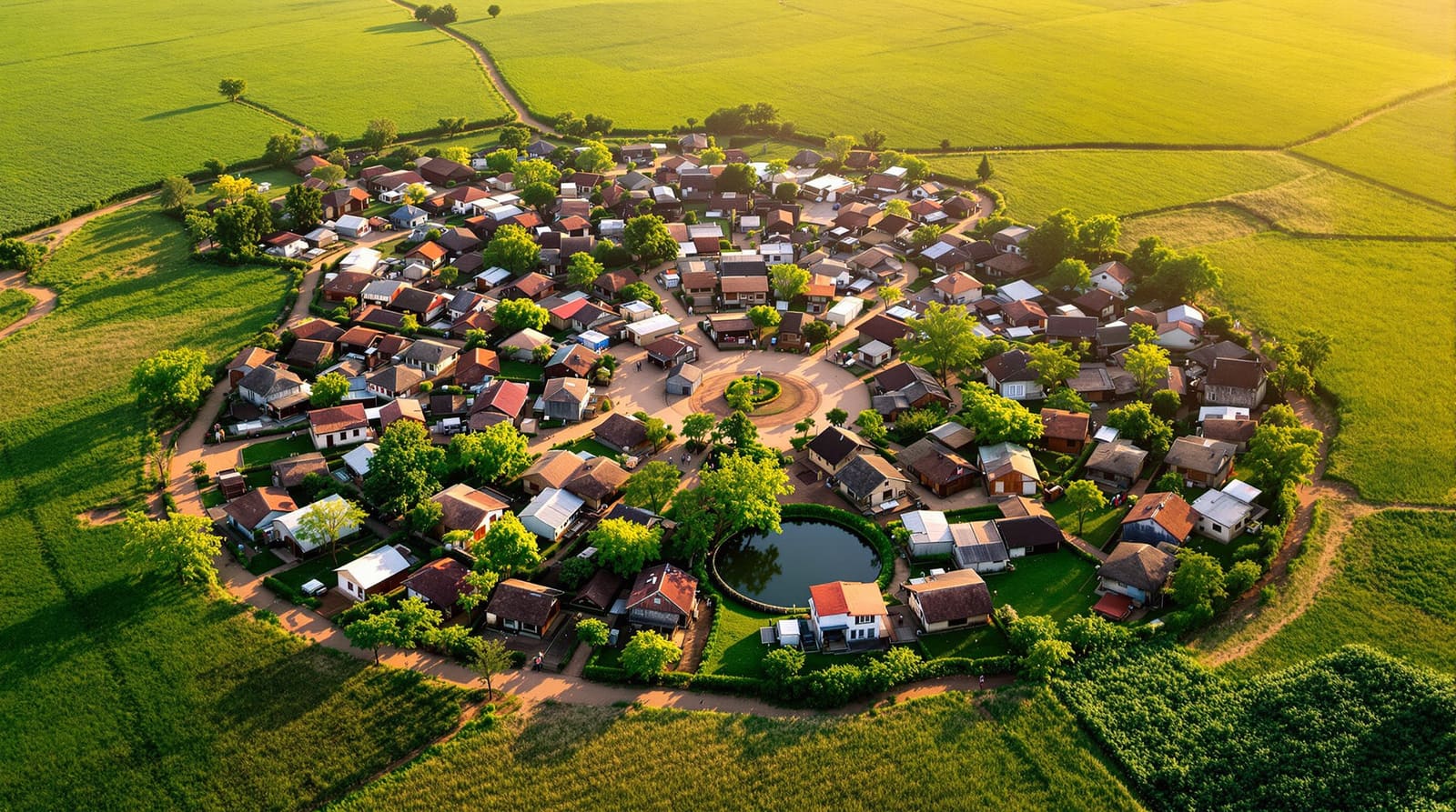
The first is clustering homesteads within a single village: laying out the houses compactly — grouped around shared commons and lanes — instead of letting them sprawl across the holdings as dispersed or strung-out linear settlement. The second is clustering whole villages: a lead village and its smaller neighbours pooling demand so that one good school, one health sub-centre, one market or one cold store serves them all. The first is a question of village form, and belongs alongside the broader rural housing layout design process and its village planning principles. The second is the model behind the government's Rurban programme. Both rest on the same arithmetic — proximity lowers the cost of shared things — and this guide is about that arithmetic, not the general layout how-to.
Sense one: clustering the homes
Walk an old organic village and you will often find it is already somewhat clustered — houses huddle for shade, for security, for the simple sociability of a shared wall and a shared lane. Modern dispersal is frequently the newer problem: a family that owns land builds in the middle of its own field, "to be near the crop," and over a generation the settlement frays into isolated farmsteads. It feels rational to each household and is expensive for all of them.

The case for compactness is concrete. Fewer running metres of road, pipe, drain and electric line per house. A water tank or solar microgrid sized for a tight settlement rather than a sprawling one. A school, a creche and a sub-centre within a child's safe walk. The threshing floor, the chaupal and the temple as genuine social nodes rather than distant landmarks. And — the point most easily forgotten — farmland kept whole. Houses scattered through the fields chop the agricultural land into awkward leftover pieces; pulling the homes to one edge or one knoll leaves the productive land contiguous and workable.
But compactness is not a free good, and a clustered layout that ignores agrarian life will be rejected — or quietly abandoned. Three things must be respected. Privacy, because the courtyard house and the women's domain do not tolerate the back-to-back overlooking of an urban row; cluster the homes, but orient and screen them so each keeps its private open space. Cattle and the agrarian household, because a farming family needs space for animals, fodder, the tractor and the implements close to home — a gauthan or shared cattle ground at the cluster edge can hold what individual plots cannot. And farm access, because a farmer pulled too far from the holding loses the dawn-to-dusk proximity that working land demands. The art is to cluster the dwelling and disperse only what truly must touch the land. This is precisely where rural clustering parts ways with urban residential density planning: the city packs homes to raise land value and ridership; the village clusters homes to save farmland and shorten service runs, and it must leave room for the bullock and the harvest the city never thinks about.
Sense two: clustering the villages — the Rurban model
Some facilities are simply too large for one small village to sustain. A secondary school, a 24-hour health centre with a delivery room, a cold-storage or food-processing unit, a piped-water treatment works, a proper market yard, a skill-training centre, a reliable bus and goods-transport node — each needs a population and an economy that a forty-household hamlet does not have. The answer is not to give every hamlet a half-built version of each. It is to choose a lead village, well connected and central to its neighbours, and locate the higher-order facility there for the whole cluster to share.

This is the thinking behind the Shyama Prasad Mukherji Rurban Mission (SPMRM), India's "Rurban cluster" programme under the Ministry of Rural Development. It identifies clusters of geographically contiguous villages — larger in the plains, smaller in tribal and hilly tracts — and invests in shared economic and social infrastructure so the cluster can urbanise gently while staying rural: that is, gain services and livelihoods without forcing migration to a city. The cluster is meant to keep its agrarian character and its identity, but to function, collectively, at a scale that delivers a real school and a real clinic. It deliberately echoes an older Indian planning idea — the growth-centre or service-village hierarchy — and a still older one in M K Gandhi's village swaraj, where self-reliant villages cooperate rather than each duplicate.
The economics: cost per household falls with clustering
The reason any of this works is arithmetic, and it is worth stating plainly. Much rural infrastructure has a high fixed cost and a low marginal cost: building a treatment unit, a road, a transformer, a cold store or a sub-centre is expensive; adding one more connected household to it is cheap. So the cost per household falls sharply as more households share the same fixed asset — and rises just as sharply when homes are scattered and each metre of service reaches fewer of them.

A drinking-water scheme illustrates it. Under the Jal Jeevan Mission, piping a tap to every home in a tight settlement is far cheaper per connection than chasing isolated farmsteads with long, leaky spurs; a single source and tank can serve a clustered village or a multi-village cluster well, where dispersed homes would each need their own falling borewell. The same holds for an all-weather PMGSY road, a solar microgrid, a DEWATS greywater system, or a composting and solid-waste point. None of this means "as compact as possible at any cost" — past a point, pulling farmers too far from their land trades a small infrastructure saving for a large livelihood loss. The honest figures vary enormously with terrain, source distance and density, so treat any single ratio with suspicion; the direction is reliable, the exact number is not. The detail of sizing these shared services belongs with rural infrastructure planning, and the digital and governance layer that increasingly rides on top — e-services, monitoring, connectivity — with smart villages.
What to cluster, and what to keep close to the land
Not everything should be pulled to the centre. The discipline is to cluster what benefits from sharing and keep dispersed what must touch the soil.

| What to cluster | The shared facility | The benefit |
|---|---|---|
| Children across hamlets | One secondary school & anganwadi in the lead village | Enough pupils & teachers to justify a real building, library & midday-meal kitchen |
| The sick & expectant mothers | A health sub-centre / clinic with a delivery bed | A viable catchment for staff, cold chain & an ambulance link |
| Farm produce & dairy | A market yard, cold store & processing / chilling unit | Better prices, less spoilage, value added before sale |
| Drinking water | One source, treatment & storage feeding all homes | Lower cost per tap; easier to test, treat & maintain |
| Power | A solar microgrid or shared transformer & biogas plant | Reliable supply at lower per-household cost |
| Movement & goods | A bus stop, transport node & all-weather road to the cluster | Real connectivity to the block town & mandi |
| The homestead & courtyard | (Kept compact but NOT merged) — private plot & open space | Privacy, the women's domain, household scale preserved |
| Farm access & cattle | (Kept dispersed / at the edge) — gauthan, fodder, tractor space | Proximity to the holding; agrarian life uninterrupted |
Making it real: size, lead village and consent
Three decisions make or break a cluster. Cluster size must follow real travel and real catchments, not a map-drawn radius: how far can a child walk, a patient be carried, a tractor reach? In tribal and hilly tracts where settlement is genuinely dispersed and terrain is hard, clusters are necessarily smaller and the lead village closer; on the plains they can be larger. Choosing the lead village should turn on centrality, road connectivity, existing assets and water, not on whose pradhan shouts loudest — and the smaller hamlets' fear of being eclipsed must be answered directly, because a hamlet that feels demoted will quietly opt out.
That points to the hardest and most important ingredient: participation, so the cluster is agreed, not imposed. India's rural development runs through the 73rd Amendment's institutions — the gram panchayat and the gram sabha, where land and layout decisions gain or lose their legitimacy. Clustering frequently needs land: either pooling and consolidation of fragmented holdings, or allocation of gram-sabha and abadi/lal-dora land for the new homesteads — now far cleaner to do where the SVAMITVA drone survey has given villagers titled record of their abadi plots. House construction itself can ride PMAY-G; assets such as roads, ponds and the gauthan can be built through MGNREGA; toilets through Swachh Bharat Mission – Gramin's twin-pit design. But none of these schemes substitutes for the sabha's assent. A cluster decided in a block office and drawn over a tribal hamlet's grazing ground will fail; one worked out with the people whose privacy, cattle and fields it rearranges will hold. The lesson the village commons has always taught — the tank, the threshing floor, the grove held in common — is that shared things survive only when they are genuinely, visibly shared.
References
1. Ministry of Rural Development, Government of India — Shyama Prasad Mukherji Rurban Mission (SPMRM): Framework for Implementation and cluster guidelines.
2. Ministry of Rural Development — Pradhan Mantri Awaas Yojana – Gramin (PMAY-G): Operational Guidelines.
3. The Constitution (Seventy-third Amendment) Act, 1992 — provisions on the gram panchayat and gram sabha.
4. Ministry of Panchayati Raj — SVAMITVA Scheme (Survey of Villages and Mapping with Improvised Technology in Village Areas), abadi-land survey guidelines.
5. URDPFI Guidelines, 2014 (Ministry of Urban Development) — settlement hierarchy, rural service-village & growth-centre norms.
6. CPHEEO, Ministry of Housing & Urban Affairs — Manual on Water Supply & Treatment and Manual on Sewerage & Sewage Treatment (rural and decentralised provisions).
7. M K Gandhi — Hind Swaraj and the writings on village swaraj and self-reliant cooperating villages.
For the full settlement-design process this clustering logic sits inside, read the rural housing layout design pillar and its modern village planning principles — then put a cluster on the map and pressure-test its layout with DesignAI.
Export this guide
Related Guides — Deep-dive reading
Rural Housing Layout Design
Planning a village housing layout from the land up — the gram-sabha process, clustered agrarian homesteads, the commons, cart lanes and decentralised services, funded through PMAY-G and SPMRM
Rural Residential PlanningSmart Villages of India
What a genuinely smart village means — appropriate technology, connectivity and good governance on a foundation of road, water, power and sanitation, honestly separated from smart-city hype
Rural Residential PlanningModern Village Planning Principles
Marrying the organic Indian village's wisdom with what modernity must add — commons first, cluster for community, mixed livelihood, decentralised self-reliance and participatory gram-sabha planning
Rural Residential PlanningRelated Tools — Try Free
Interior Layout Planner — Printable Graph Grid
Printable graph grid to sketch room layouts to scale before committing to furniture placement.
Layout ToolRainwater Tank Sizer
How big should your rainwater tank be? Computes annual harvest, recommended tank capacity in litres, water-bill savings, and payback — for 10 Indian cities.
RWH CalculatorApartment vs Villa Interior Planning Guide
Compare ceiling height, structural flexibility, lighting, storage, and services between apartments and villas.
Planning Guide