
Residential Plot Distribution Strategies
How to divide land into plots — the plot-size mix, frontage-to-depth ratios, single vs double-loaded streets, corner plots, frontage efficiency and the land budget
Walk into a half-sold plotted scheme on the edge of a Tier-2 Indian city — the kind advertised on hoardings with the words "RERA approved, ready for registration" — and you can read the developer's mind in the ground itself. Near the entrance arch sit a clutch of generous plots, the ones marketed to doctors and NRIs, each facing east, each on a corner if the geometry allowed it. Behind them, ranks of tidier, more affordable plots line a grid of internal roads, two rows deep between every pair of streets. A child's cricket match spills across a strip of land marked "open space — handed over to authority", and a small parcel near the back is fenced off and labelled, almost apologetically, "EWS reservation". Nothing here is accidental. Every line was drawn to answer one quiet question: how do you carve a field into pieces that sell, that build into a real place, and that still pass the approval desk?
That carving — the act of slicing developable land into individual sellable plots — is the most consequential and least understood decision in layout-making. Get the road network slightly wrong and you waste money; get the plotting wrong and you waste the land forever, because once plots are registered and built upon, the geometry is fixed for a century. Plot distribution is the economic engine of a layout: a good subdivision squeezes the maximum saleable frontage out of the minimum road length, offers a deliberate range of plot sizes to a real community, and respects setbacks and amenity reservations so that what is sold can actually be built and lived in.
The block is the unit, not the plot
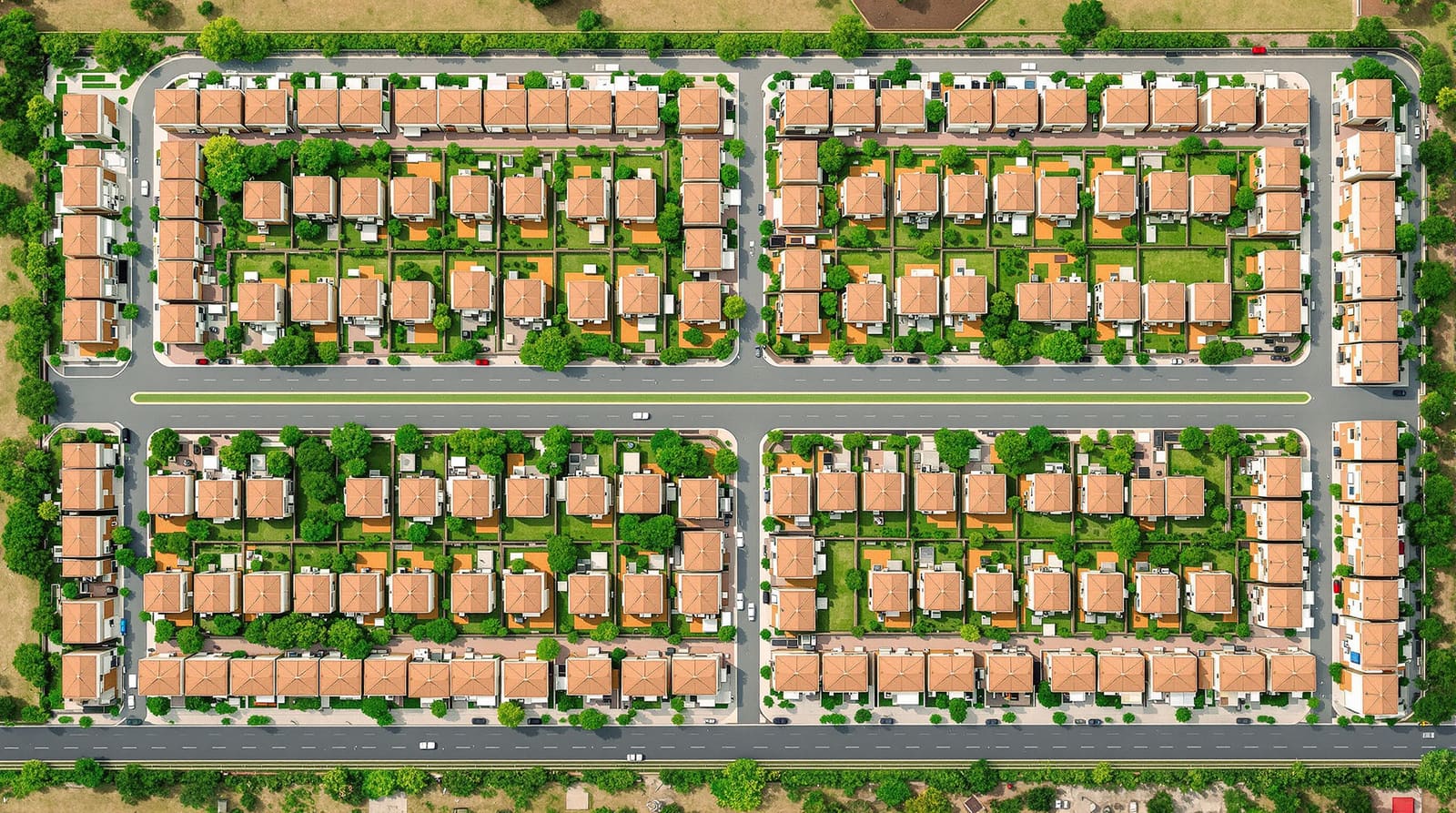
The instinct of the beginner is to start by drawing plots. The instinct of the planner is to start by drawing the block — the parcel of land enclosed by roads on all sides — and only then to subdivide it. This matters because almost every economic and physical property of a plot is inherited from the block it sits in: its depth, its access, whether it can be back-to-back with a neighbour, whether it catches a corner.
A residential layout, viewed honestly, is a tessellation of blocks separated by a hierarchy of streets, with each block divided into plots that face those streets. The plot is the retail unit; the block is the wholesale unit; the street is the cost. Understanding plotting means holding all three in view at once. The street network itself — what each road does and how wide it should be — is a discipline of its own, covered in street hierarchy explained; here we treat streets mainly as the edges that give plots their frontage and as the single biggest cost to be minimised.
This guide sits one rung below the pillar on designing a residential layout, which walks the whole process end to end. Two of the decisions that feel like plotting are deliberately handed off: how many dwellings per hectare you are aiming for (and the FSI that drives it) belongs to residential density planning, and how much land you set aside for parks and greens belongs to open space planning. What remains — the mechanics and economics of cutting the saleable land into plots — is our subject.
Plot dimensions: frontage, depth and the ideal ratio
A plot has two dimensions that decide almost everything about it: its frontage (the width along the road) and its depth (the dimension running back from the road). The relationship between them — the frontage-to-depth ratio — is where good plotting lives.
Frontage is expensive. Every metre of frontage you give a plot is a metre of road, kerb, drain, water main, sewer and electrical cable the developer (or the authority) must build and maintain in front of it. Depth is comparatively cheap — it is just land. So the developer's instinct is always to make plots narrow and deep, packing more plots onto each metre of road. The homeowner's and the builder's instinct pulls the other way: a plot that is too narrow cannot accommodate setbacks on both sides and still leave a usable house in the middle. Indian Development Control Regulations (DCR) typically mandate side setbacks of a metre or more on plots above a certain size, so a 6 m-wide plot can be eaten alive by margins, leaving a corridor of a house.
The conventional resolution is a frontage-to-depth ratio in the region of 1:2 to 1:2.5 — twice to two-and-a-half times as deep as it is wide. A plot of roughly 9 m frontage by 18–20 m depth (about 160–180 sq m) is a workhorse of Indian plotted development: wide enough to lose the side setbacks gracefully, deep enough to be efficient. Ratios much beyond 1:3 produce tunnel-like plots that are dark at the centre and awkward to build on; ratios approaching 1:1 are luxurious but burn frontage. Minimum plot sizes and minimum road frontages are themselves regulated — many state Town & Country Planning rules set a minimum frontage (commonly 6–9 m for the smallest residential plots) below which a parcel cannot be registered as a building plot at all. How those numbers translate into what you can actually build is the domain of setbacks across India.
The plot mix: a range that serves a community and the market
A layout made entirely of identical plots is a planning failure and a marketing one. Real neighbourhoods are mixed because real households are mixed — a young couple, a joint family, a retired schoolteacher and a builder assembling two plots for a small apartment block all want different things, and a developer who offers only one product can sell to only one buyer at a time.
The discipline here is to design a plot-size mix the way a retailer designs a product range: a spread of small, medium and large plots in deliberate proportions. The bulk of plots in most Indian schemes are the medium "bread-and-butter" sizes, because that is where the market is deepest and absorption is fastest. A smaller tranche of larger premium plots — corner, east-facing, park-facing — carries higher margins and anchors the scheme's image. A tranche of genuinely small plots widens the buyer base and, in several states, is no longer optional: affordable and EWS (Economically Weaker Section) plot reservation is mandated, of which more below.

The mix is also a hedge. Markets move; if premium plots stall, a scheme weighted entirely to them stalls with them, whereas a mix keeps cash flowing from the fast-moving sizes while the premium plots wait for their buyer. The table below is illustrative — exact dimensions and minimums vary by state DCR and by the authority approving the layout — but it captures the logic of who each plot serves.
| Plot type | Typical plot area | Indicative dimensions (frontage & depth) | Who it serves |
|---|---|---|---|
| Small / affordable | ~75–110 sq m | ~6 m & ~14 m | First-time buyers, EWS & LIG households, compact homes |
| Standard medium | ~110–185 sq m | ~9 m & ~16–20 m | The market core — nuclear & small joint families |
| Large | ~185–280 sq m | ~12 m & ~18–22 m | Larger joint families, premium independent houses |
| Premium / corner / facing | ~280 sq m & above | ~15 m+ & ~18 m+ | High-budget buyers, builder-floors, Vastu-driven demand |
Frontage efficiency: the developer's core trade-off
If there is a single number that decides whether a plotting scheme makes or loses money, it is frontage efficiency — the ratio of saleable plot frontage delivered to road length built. Roads are pure cost: land that earns nothing, plus the capital cost of the carriageway and every service laid beneath it. Plots are pure revenue. The whole art of subdivision is to build as little road as possible while still giving every plot legal, buildable access.

Two levers dominate. The first is plot proportion, already discussed: deeper, narrower plots squeeze more units onto each metre of road. The second is how plots are arranged along the street — the difference between single-loaded and double-loaded streets.
A single-loaded street has plots on one side only; the other side faces a park, a nallah, a boundary or nothing. Every rupee of that road is paying to serve a single row of plots — half-efficient by definition. A double-loaded street has plots on both sides, so the same carriageway, the same water main, the same drain serve two rows at once. Double-loading roughly doubles the frontage earned per metre of road, which is why the overwhelming majority of internal streets in well-planned Indian layouts are double-loaded.

The companion idea is back-to-back plotting: within a block, two rows of plots share a common rear boundary, their backs against each other, each row facing its own street. A standard double-loaded block is therefore four rows of frontage — two streets, two rows of back-to-back plots each — with no land wasted on rear access. Single-loaded streets and corners do have their place; a single-loaded edge along a green or a lake commands a premium precisely because of its outlook, and a scheme that is only about efficiency feels mean. But efficiency is the default, and every departure from it must earn its keep in price.

Corner plots: premium but tricky
Corner plots — those at the intersection of two streets, with frontage on two sides — are the most coveted and the most awkward parcels in any layout. They are premium because they offer two open sides (more light, more air, two possible entrances, often a side garden) and, in the Indian market, because a corner can be oriented to satisfy Vastu for plot selection far more flexibly than a mid-block plot. Developers routinely price them higher and place them deliberately to anchor block corners.
They are tricky because they pay setbacks on two road sides, not one, which eats buildable area; because authorities often require the corner itself to be splayed or rounded for visibility, shaving the plot; and because each block has only four of them. A corner is a scarce, high-margin product that the plotting layout must manufacture intentionally — orient the premium corners east and north where you can, and accept that you cannot make many.
The land budget and the saleable ratio
Step back from the individual plot and a layout is a budget of land. Total developable area splits, broadly, four ways: saleable plot area, roads, mandated open space, and land for amenities and utilities (parks already being counted as open space, this last covers community facilities, the electrical substation, water tanks, the pump house and so on).
The headline metric is the saleable ratio (sometimes called the efficiency ratio): saleable plot area as a fraction of gross site area. In Indian plotted schemes this commonly lands somewhere around 55–65 per cent — meaning a third or more of the land is "given away" to roads, open space and amenities before a single plot is sold. That sounds wasteful and is in fact the opposite: those non-saleable elements are exactly what make the saleable land valuable and legal to sell. A typical land budget looks like this:
| Land component | Indicative share of gross area | Notes |
|---|---|---|
| Saleable plots | ~55–65% | The revenue; maximise via frontage efficiency & plot proportion |
| Roads & circulation | ~20–30% | Pure cost; minimised by double-loading & block geometry |
| Open space / parks | ~10% (varies by state) | Often a statutory minimum; see open-space guide |
| Amenities, EWS & utilities | balance | Community sites, substation, tanks, reserved plots |
Two of these line items are governed by other guides. The roads share is the flip side of street hierarchy, and the open-space share — frequently a statutory minimum of around 10 per cent, varying by state and authority — is the subject of open space planning for residential layouts. The plotter's job is to push the saleable ratio as high as the rules and good sense allow, knowing that every percentage point recovered from road length is margin, and every point lost to bad block geometry is gone for good.
Equity, setbacks and the building yet to come
Two forces keep pure efficiency honest. The first is equity. Several Indian states now require plotted developments above a threshold to reserve a portion of plots, or of land, for EWS and LIG (Lower Income Group) housing — sometimes 10–20 per cent of plots, sometimes met by handing over developed plots or by a payment in lieu, with the exact mechanism varying sharply by state and by whether the scheme falls under a slum or affordable-housing policy. A well-designed layout integrates these plots into the fabric rather than banishing them to the least desirable corner; a layout that ghettoises its affordable plots is both socially poorer and, increasingly, in breach of approval conditions.
The second is the building that has not been built yet. A plot is sold as land but lives as a house, and the plotting must anticipate the envelope that DCR setbacks, ground coverage and FSI will eventually carve out of it. A plot too narrow to lose its side margins, or too shallow to hold a rear setback and a usable depth, is a plot that disappoints its buyer and dents the scheme's reputation. This is where plotting hands off to the single-plot scale: how to evaluate a residential plot is the buyer's-eye companion to everything above, and the relationship between plot size and buildable envelope runs through setbacks across India. The plotter's discipline is to never draw a plot that cannot become a good house.
In India: DTCP norms, approvals and the corner-plot obsession
In India, none of this is left to taste. A plotted layout must be sanctioned by the relevant planning authority — the state Director of Town & Country Planning (DTCP) in many states, or a development authority such as BDA, CMDA, HMDA or the local Urban Development Authority — against the master plan land-use and the prevailing DCR. The approval fixes minimum plot sizes, minimum road frontage, road widths, the open-space and amenity reservations, and increasingly the EWS share. Crucially, layout approval is distinct from individual building-plan sanction: the layout legalises the plots and roads, while each plot owner later seeks a separate building permit. Since RERA, plotted developments above the prescribed threshold must also be RERA-registered, which has sharply raised the premium on getting the plotting right on paper before anything is sold.
Layered on top of the regulatory grid is the market's deep preference, rooted in Vastu, for east- and north-facing plots and for corners — a preference so strong that it measurably reprices land within a single scheme. Sensible plotters work with it: where the street geometry allows, they orient premium and corner plots to catch the favoured aspects, knowing the same patch of earth sells for more facing east than facing west. It is the clearest proof that plotting is never purely a geometric exercise — it is geometry in the service of a market, a regulator and a community at once.
References
- Clarence Perry, The Neighbourhood Unit (Regional Plan of New York, 1929).
- Jane Jacobs, The Death and Life of Great American Cities (1961) — short blocks and the life of the street.
- Kevin Lynch, The Image of the City (1960) — paths, edges and legibility.
- URDPFI Guidelines, 2014 (Ministry of Urban Development, Government of India) — land-use, plot and open-space norms.
- Relevant State Town & Country Planning Act and Development Control Regulations (e.g. Tamil Nadu, Karnataka, Telangana, Maharashtra) — minimum plot size, frontage and layout-approval rules.
- National Building Code of India (NBC), 2016 — setbacks, plot coverage and access provisions.
- Jeff Speck, Walkable City (2012) — block size, frontage and the economics of street length.
See also residential density planning and open space planning for residential layouts — and plan and visualise your own plotting strategy with DesignAI.
Export this guide
Related Guides — Deep-dive reading
How Urban Regulations Shape Cities in India
How the abstract rulebook of FAR, setbacks, height, parking and zoning literally builds the streets, skylines and neighbourhoods you live in
Building Regulations & ComplianceSite Analysis for Homeowners: How to Read a Plot Before You Build
The master guide to reading your land — its legal envelope, sun, wind, slope, soil, access, neighbours, views, services and microclimate — before you buy a plot or draw a plan.
Site PlanningWhy Setbacks Matter: A Homeowner's Guide to the Open Space Around Your House
What setbacks are, the daylight, air, fire-access and privacy jobs they do, how they scale with plot and height, and why eating them up costs you your occupancy certificate and resale value
Building Regulations & ComplianceRelated Tools — Try Free
Stamp Duty Calculator — All Indian States
Stamp duty + registration charges for all 28 states and 8 UTs — gender concessions, urban/rural variants, metro cess built in.
Stamp DutyApartment Video Door System Planner
Enter flats, entrances, floors and guard desk for a first-pass building intercom plan — door stations, indoor monitors, guard station, the right architecture and an indicative cost band.
Building PlannerBuilding Plan Approval Roadmap
Step-by-step building plan approval process by city with documents, timelines, and fees.
ArchitectAI