
Open Space Planning
Planning the parks of a layout — the open-space hierarchy and catchment, the mandated reservation, equitable distribution, types of open space and the connected green network
On a Sunday evening in a fifteen-year-old layout on the edge of Pune, you can read the quality of its planning in five minutes of walking. Children orbit a small play area at the foot of a cluster of homes — close enough that a grandmother can watch from her balcony. A few hundred metres on, a proper neighbourhood park opens up: a shaded lawn, a walking loop worn smooth by morning regulars, benches under a rain tree, and homes turned to face it rather than back away. The park is not an afterthought wedged behind a transformer yard. It sits where the layout meant it to sit, and the whole neighbourhood is richer for it.
Walk a kilometre across to the layout next door and the contrast is brutal. The "open space" there is a triangular sliver of weeds left over after the plots were carved out — too narrow to play in, overlooked by nobody, and now half-claimed by a parked tempo and a slowly creeping compound wall. On paper both layouts reserved the same ten percent of land for greenery. Only one of them actually got a park. Open space in a residential layout is only valuable when it is planned as a connected, distributed, usable system — a hierarchy of greens within walking reach of every home — and not surrendered as the awkward land left over when the saleable plots have been drawn.
Open space is a hierarchy, not a number
The single biggest mistake in Indian layout planning is treating open space as a percentage to be satisfied rather than a system to be designed. The reservation — commonly around ten percent of the layout area, though it varies meaningfully by state Development Control Regulations and the size and category of the scheme — is a floor, not a design. What turns that floor into a real amenity is distribution and hierarchy: a graded family of open spaces, each sized for a different distance a person is willing to walk.
Planners have understood this since Clarence Perry codified the Neighbourhood Unit in the 1920s, placing a park and school at the heart of a unit small enough that no child crosses a major road to reach them. Kevin Lynch's idea of legibility applies too — a good open-space system gives the neighbourhood its nodes and landmarks, the places people name and navigate by. The hierarchy works because catchment and walking distance are linked: the smallest greens sit at the doorstep, the largest serve a whole district.

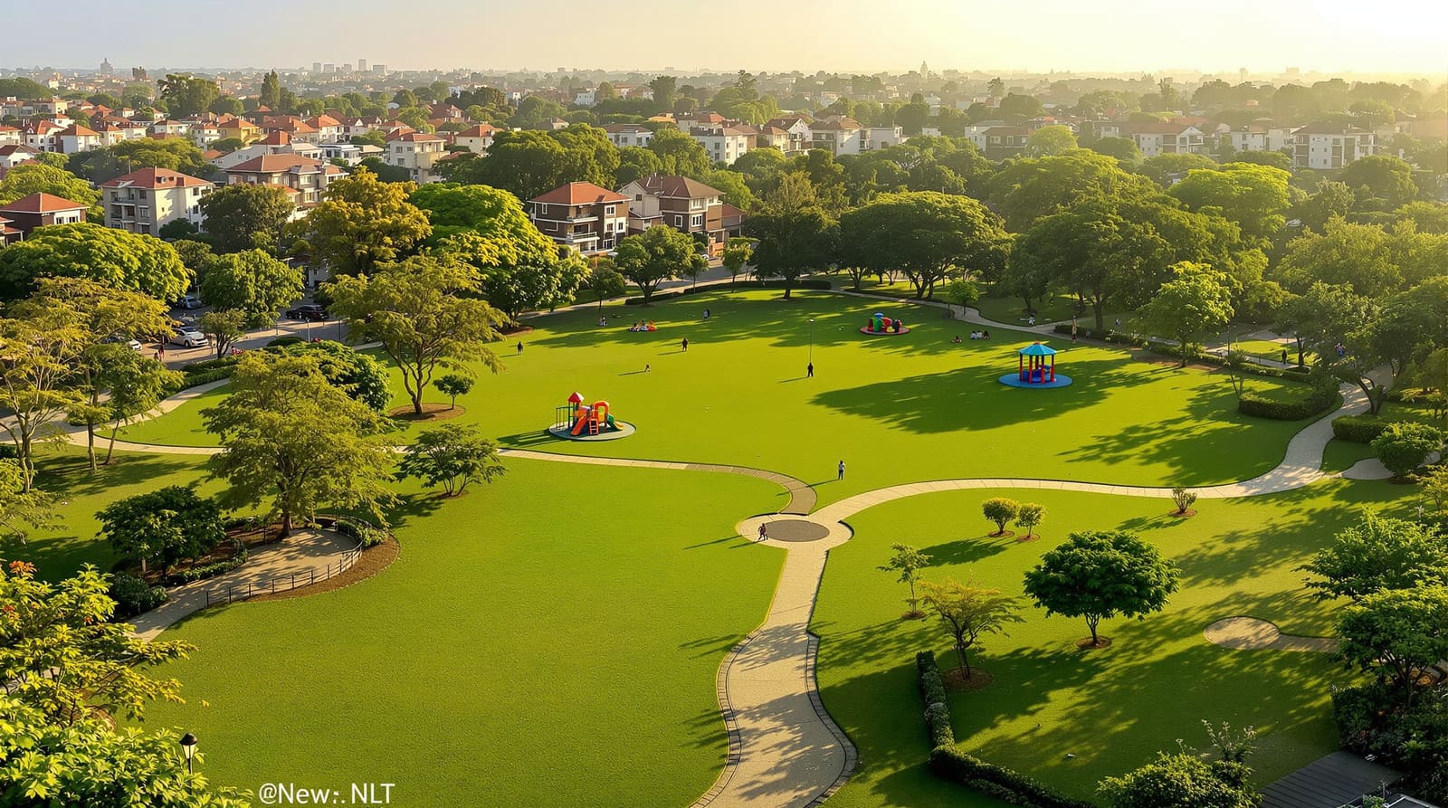
At the bottom of the hierarchy is the tot-lot or doorstep play area — small, perhaps a few hundred square metres, serving the immediate cluster of homes within a thirty-to-sixty-second walk. Its whole value is proximity and supervision: a toddler should reach it without crossing a vehicular street, and an adult should be able to keep an eye on it from a window. Above that sits the neighbourhood park, the workhorse of the system — typically reachable in a five-minute walk (roughly 400 metres), large enough for a lawn, a walking loop, shade trees and a children's area used by several hundred households. Then the community or district park, serving a much larger catchment with sports, gathering space and mature landscape, accepting a longer walk or a short cycle. Binding all of these together is the green network — the corridors, tree-lined streets and natural-feature edges that let you move from one green to the next without ever feeling you have left the system.
This graded logic is exactly why a single large central park, however handsome, is not enough. A layout that puts all its reserved land in one corner satisfies the ten percent but strands half its residents a long, hot walk away. The URDPFI Guidelines and most good planning practice push the opposite way: many smaller greens, equitably spread, beat one big leftover.
Distribution: every home within a short walk of a green
The test of an open-space plan is simple and unforgiving. Stand at any plot in the layout and ask: how far, and how safely, can a five-year-old or a seventy-year-old reach a green? If the honest answer for some homes is "across an arterial road and four hundred metres of unshaded footpath", the plan has failed those homes regardless of what the area statement says.

Equitable distribution means the greens are located first, as fixing points the rest of the layout is drawn around — not extracted last from whatever scraps remain. In practice this means seeding small play areas inside each residential cluster, placing the neighbourhood park near the centre of gravity of the homes it serves, and aligning it with safe pedestrian routes so the walk to it is pleasant rather than punishing. The 15-minute-city thinking of Carlos Moreno and Jeff Speck's walkability arguments both land here: a green is only "accessible" if the route to it is genuinely walkable, shaded and free of dangerous crossings. This is where open-space planning and street design must be coordinated — work the route quality alongside walkable neighbourhood design, and locate the greens within the framework set by your layout planning principles.
Distribution also governs shape and edge. A park that is a long thin strip, or that backs onto compound walls and service yards, gets neither used nor watched. Jane Jacobs's "eyes on the street" is really an argument about overlooking: greens should be fronted by homes, with windows and entrances facing in, so the space is naturally surveilled and feels safe at dusk. A compact, well-proportioned park ringed by active frontages will outperform a larger one hemmed in by blank walls every time.
Types of open space and the roles they play
Not all greens do the same job, and a good layout deliberately includes several kinds. Distinguishing them keeps you from building five identical lawns and no place to actually play cricket.

Active open space is for movement and sport — play courts, a multi-purpose ground, jogging loops, outdoor gyms. It needs flat, durable surfaces and tolerates noise, so it sits well away from bedroom-facing edges. Passive open space is the garden register — shaded seating, lawns, sensory planting, places for the elderly and for quiet gathering. Civic or plaza space is the hard-paved heart where the community meets: a temple forecourt, a market edge, a festival ground. These are the places that host Ganesh visarjan processions, Diwali gatherings and weddings, and Indian layouts ignore them at their peril. Greenway and buffer space runs linear — along streets, drains, high-tension lines and layout edges — softening, screening and, crucially, connecting. Ecological and retention space earns its keep environmentally: bioswales, rain gardens, retention ponds and preserved tree stands that manage stormwater and cool the microclimate. This is the natural seam to water-led greens — design retention areas in concert with blue-green infrastructure and the broader logic of water sensitive urban design, so a single piece of land works as both a park and a stormwater sponge.
| Open-space type | Typical size & catchment | Primary function |
|---|---|---|
| Tot-lot / doorstep play | ~200–800 sq m, ~1 min walk (cluster) | Toddler play, supervised, no road crossing |
| Neighbourhood park | ~0.2–1 ha, ~5 min walk (~400 m) | Daily use — lawn, loop, shade, children & elders |
| Community / district park | ~1–4 ha+, ~10–15 min walk / short cycle | Sports, events, mature landscape, gathering |
| Civic plaza / festival ground | Varies, central & visible | Markets, processions, community gatherings |
| Greenway / buffer | Linear, along streets, drains & edges | Connection, shade, screening, walking & cycling |
| Ecological / retention | Varies, follows low ground & water | Stormwater management, cooling, biodiversity |
These figures are illustrative — actual sizes and catchments vary by state DCR, scheme category and density, so always reconcile them with your local authority's norms. Match the types to the homes around them through your residential plot distribution and density assumptions; a high-density cluster needs more, smaller doorstep greens than a plotted-bungalow zone.
The green network: linking greens into one system
The leap from "we have parks" to "we have a neighbourhood" is the network. The most influential demonstration of this is the Radburn layout of 1929, which threaded a continuous pedestrian greenway through the interior of its superblocks, separated traffic, and let residents walk from home to park to school without crossing a road. New Urbanism and Traditional Neighbourhood Development inherited the idea: open space should form a connected armature, not a set of disconnected islands.

In practice the network is built from the linear greens — tree-lined collector streets, buffer strips along drains and the layout perimeter, and pedestrian spines — stitched to the parks they pass. A nala or seasonal stream, too often culverted and forgotten, becomes the spine of a linear park. An existing grove of trees becomes a node. Done well, the green network doubles as the walking-and-cycling network and the stormwater drainage corridor at once, which is why it pays to design it alongside the residential site planning landscape rather than as a separate layer. Note the lane this guide keeps to: the system between and around plots. The greenery inside a private plot — the family's own garden, terrace and activity zones — is a different scale handled in landscape zoning for family activities.
In India: leftover land, encroachment, ownership and value
Indian layout approval runs through the local Town and Country Planning department or development authority — DTCP, BDA, CMDA, HMDA, MCGM and their state cousins — under the master plan, the building bye-laws and the Development Control Regulations, with RERA registration now required for plotted developments. Most state DCRs mandate an open-space reservation, often in the region of ten percent, and many require it to be handed over to the local body, free of cost and free of encumbrance, once the layout is developed. That handover clause is where good intentions die. Three Indian pathologies recur.
First, the leftover-land problem: developers maximise saleable plots and donate the residual scraps as "open space", technically meeting the percentage while delivering unusable slivers. The fix is regulatory and ethical — fix the greens first, insist on minimum dimensions and frontage, and refuse to count buffers along high-tension lines or steep nalas as if they were parks. Second, encroachment: handed-over but unmaintained open space is steadily eaten by parking, sheds, temples-turned-permanent and creeping walls. A green that is overlooked, fenced sensibly, lit and actively used resists encroachment far better than a neglected one — Jacobs's surveillance argument is also an anti-encroachment argument. Third, ownership and maintenance ambiguity: after handover the municipality is responsible but often under-resourced, while the resident welfare association has the motive but not always the mandate. The healthiest layouts settle this early, frequently through an RWA maintenance arrangement, a sinking fund or a formal arrangement with the local body.
The payoff for getting it right is measurable. A genuine, well-kept neighbourhood park lifts the value and desirability of every plot that fronts or overlooks it — the green is an amenity the whole layout capitalises into its land. This connects to the larger ambition of future-ready residential layouts: open space is climate infrastructure (shade, cooling, stormwater) as much as recreation, and layouts that treat it that way age far better. For the full process this sits within, see the pillar — how to design a residential layout.
References
1. Clarence Perry, "The Neighbourhood Unit" (Regional Survey of New York and Its Environs, 1929).
2. Jane Jacobs, The Death and Life of Great American Cities (1961).
3. Kevin Lynch, The Image of the City (1960).
4. Jeff Speck, Walkable City (2012).
5. URDPFI Guidelines, 2014 (Ministry of Urban Development, Government of India) — open-space and recreational standards.
6. Relevant State Town & Country Planning Act and Development Control Regulations (e.g. layout open-space reservation and handover provisions).
7. National Building Code of India (Bureau of Indian Standards) — relevant provisions on open spaces and amenities.
Read this alongside walkable neighbourhood design and blue-green infrastructure, and use DesignAI to plan and visualise your layout's open-space system before a single plot line is drawn.
Export this guide
Related Guides — Deep-dive reading
The Street, Mathura: How Sanjay Puri Turned a Corridor into a Community
At GLA University near Mathura, Sanjay Puri Architects folded 800 hostel rooms into five snaking, four-storey blocks so that the leftover space between them became a genuine pedestrian street — a low-cost, climate-tuned answer to the question of how young people should live together, drawn from the winding lanes of an old Indian city.
The Future of ArchitectureLandscape Zoning for Family Activities
Organising the home garden into activity zones — gather, play, grow, relax, pets, service — and relating them across ages, times and seasons
LandscapeSchool Planning Inside Townships
Schools as township amenities — how many of what type by population, the walk-to-school catchment, safe siting away from arterials, the school-park pairing and safe routes
Township PlanningRelated Tools — Try Free
Cross-Ventilation Analyzer
Estimate airflow and air changes per hour (ACH) from room size, window areas, layout, and local wind — with NBC 2016 Part 8 compliance check.
Ventilation CalculatorGarden Planning Toolkit
Get a tailored garden plan — planting layers, Indian species, features and a checklist — from your climate, space, sun and goals.
PlannerMonsoon-Readiness Checklist
Pre-rain home audit across 9 categories — terrace, drains, waterproofing, electrical, HVAC, pest, vehicles, documents.
Seasonal Audit