
Designing a Residential Township
Planning a township as a self-contained system — many neighbourhoods plus shared schools, healthcare, parks and community facilities, served by trunk roads, water, power and stormwater
At 6.40 in the morning, the spine road of a township on the edge of Pune is already busy with a particular kind of traffic — none of it leaving. School vans idle outside the K-12 campus; a cluster of residents walks the lake loop before the heat arrives; the wet-waste truck turns into the materials-recovery yard behind the retail plaza; and a plumber on a scooter heads to Sector 4, where 1,800 homes draw their water from a common overhead reservoir fed by the township's own treatment plant. Nobody here is commuting to a clinic, a kirana, a park or a primary school in another part of the city. They have all of those things inside the boundary wall, planned years before the first slab was poured.
That is the quiet ambition of a township: to be a town that someone designed on purpose. Not a single colony of plots, not one apartment complex, but several residential neighbourhoods stitched together and served by their own schools, health centre, parks, shops, roads, water, sewerage, power and stormwater — and held together by a body that maintains all of it after the developer leaves. Designing a township is not designing a bigger layout; it is designing a self-contained urban system, where every neighbourhood is sized to the amenities and trunk infrastructure that will serve thousands of homes for decades.
A township is a system, not a neighbourhood
The single most useful mental shift is one of scale. A residential layout — the subject of how to design a residential layout — is one neighbourhood: a few hundred to a couple of thousand homes around a park, served by streets that connect to the city outside. A township is the level above that. It is many such neighbourhoods, plus the shared social infrastructure they cannot each afford on their own, plus the trunk networks that feed every neighbourhood from a common source.
Think of it as three layers stacked together. At the bottom sit the residential cells — the neighbourhoods or sectors, each walkable, each with its own pocket park and local street. In the middle sit the shared amenities — schools, a health facility, community halls, a retail centre, large parks — sized not for one cell but for the whole population. At the top sits the trunk infrastructure — the arterial roads, the water source and reservoir, the sewage treatment plant, the power substation, the stormwater drains — which exists only at township scale and which no single neighbourhood could justify.

This is also where the township differs from its aspirational cousin. The vision of the future Indian township describes what we want a township to become — net-zero, water-positive, walkable, technologically alive. This guide is about the process of getting there: the disciplined sequence of decisions that turns raw land into a working settlement. Vision sets the destination; the process is how you arrive without bankrupting the project or stranding residents without a school.
The structure plan: a centre, sectors and a green-blue spine
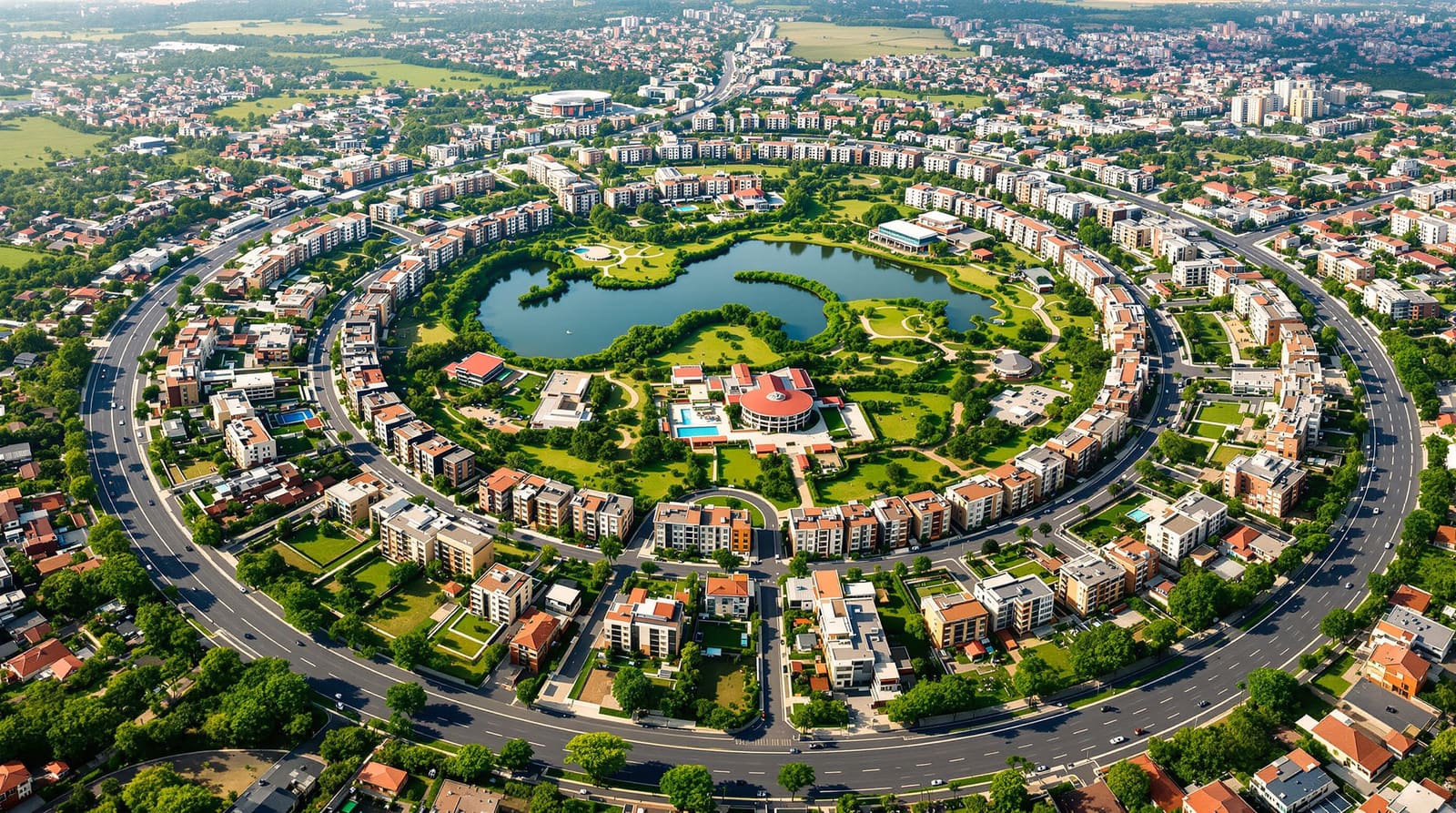
Every good township has a legible structure — a diagram you could sketch on the back of an envelope and that residents could navigate without a map. The structure plan establishes that diagram before any plot is drawn. It does three things at once: it locates a centre, it divides the land into sectors and neighbourhoods, and it threads a continuous green-blue network through everything.
The centre is where the township's shared life concentrates — the retail plaza, the larger community facilities, often a transit node and the higher-order schools and health centre. Around it the residential sectors are arranged so that most homes fall within a comfortable walk of daily needs. The catchment idea — that a primary school, a pocket park or a convenience shop should sit roughly within 400 to 800 metres of the homes it serves — drives the spacing. The green-blue network is the connective tissue: parks, tree-lined avenues, swales and water bodies linked into a continuous system rather than scattered as leftover patches, so that stormwater, recreation and cooling all travel along the same corridors.

The amenity hierarchy follows directly from this structure, and it is worth naming explicitly because it governs everything that comes after. The URDPFI Guidelines 2014 — India's reference for urban and regional development plans — organise social infrastructure by population threshold: things you provide per neighbourhood, things you provide per sector or cluster of neighbourhoods, and things you provide once for the whole township. A pocket park and a pre-primary school belong to the neighbourhood; a higher secondary school, a community hall and a dispensary belong to the sector; a hospital, a large sports complex and the town park belong to the township as a whole. Get this hierarchy right and the land-use math almost solves itself.
The process: from site to phased delivery
The work proceeds in a deliberate order, because each decision constrains the next. Skipping ahead — laying out plots before you have confirmed the water source, say — is how townships end up retrofitting infrastructure at three times the cost.

It begins with site and context: reading the land's slope, drainage lines, soil, existing trees and water bodies, and the connections to the city beyond — the highway interchange, the existing trunk water main, the grid feeder. The natural drainage especially should be respected, not erased, because it will become the spine of the stormwater system. From this reading comes a master concept — the big idea for how the township sits on its land and relates to its surroundings.
Next comes the structure plan described above, then the land-use balance — apportioning the gross area between residential, amenities, commercial, open space, roads and utilities. Only then is it sensible to do detailed amenity provisioning (sizing each school, health facility and park to the projected population) and to design the trunk infrastructure backbone that will feed them. Approvals — the integrated-township sanction, environmental clearance, RERA registration — run alongside. And finally phased delivery, because no township is built at once; it grows in phases, each of which must be liveable on its own.
Land-use balance: how the acres divide

The land budget is the township's constitution. Decide it early, defend it against the relentless pressure to convert open space and amenity land into saleable plots, and the settlement will work; let it erode and you get the familiar Indian result — dense housing with starved parks, overloaded roads and a school that never got built. The shares below are indicative, drawn loosely from URDPFI-aligned planning practice; the exact split depends on density, topography and the state's township policy, so treat them as a starting frame, not a rule.
| Land-use category | Indicative share of gross area | What it covers & why it matters |
|---|---|---|
| Residential | 45–55% | The neighbourhoods & sectors themselves — plots, group housing, internal lanes & pocket parks |
| Roads & circulation | 12–18% | Trunk & sector roads, junctions, parking & transit — see township road hierarchy |
| Open space & recreation | 12–18% | Town park, sector parks, the green-blue network, sports — see parks & recreation |
| Amenities (social infrastructure) | 8–12% | Schools, health, community halls, worship, civic — sized per population, not per cell |
| Commercial & mixed use | 4–6% | The retail centre, local shops, offices & work-near-home space |
| Utilities & services | 3–5% | Water treatment & reservoirs, sewage treatment plant, substation, solid-waste yard, stormwater works |
The discipline is to lock the open-space and amenity shares first and let residential take what remains, rather than the other way round. A township that quietly trims its park land to 6% and its school land to 4% will sell faster and live worse.
Provisioning the amenities by population
Amenities in a township are not sized by intuition; they are sized by people. The URDPFI thresholds give population numbers at which each facility becomes warranted, and the township planner's job is to place the right facility at the right level of the hierarchy. This pillar only signposts the sub-topics — each has its own sibling guide that goes deep on norms, siting and sizing.
- Education. From pre-primary in each neighbourhood to a higher secondary school and possibly a college at township level, schools are among the largest single amenity land users and the strongest sales driver. Plan their plots, access and catchments early — see school planning.
- Healthcare. A dispensary or polyclinic per sector, scaling up to a nursing home or hospital for the whole township, depending on population. This is the township's amenity plan, distinct from designing the building itself — see healthcare facilities.
- Parks and recreation. The graded open-space system from pocket parks to the town park and sports complex, woven into the green-blue network — see parks & recreation.
- Community and civic facilities. Community halls, libraries, places of worship, a fire station, post and police facilities and local markets — the social glue — see community facilities.
The trunk-infrastructure backbone
Beneath the visible township runs the part no resident sees until it fails. Trunk infrastructure is the township-scale network that brings resources to the neighbourhood gate; from there, local distribution carries them the last stretch. Designing the trunk before the plots is non-negotiable, because corridors, treatment plants and substations need land reserved up front.
- Roads. A clear hierarchy from arterial spine to sector roads to local lanes, designed to IRC standards, that moves traffic without slicing neighbourhoods apart — see township road hierarchy.
- Water, sewerage and power. The source, treatment and reservoir for water; the collection network and STP for sewage; the substation and ring feeders for power; all sized using CPHEEO manuals and NBC 2016 and laid in coordinated common corridors — see utility networks.
- Stormwater. In monsoon India this is the make-or-break system: a drainage network aligned to the site's natural flow, with detention and recharge, so the township does not flood its own streets — see stormwater planning.
For the technologies that increasingly ride on this backbone — recycled water, rooftop solar microgrids, sensors and smart management — see future smart townships.
Approvals, policy and RERA
A township is a regulatory animal. Most states run an integrated-township policy or scheme — Maharashtra, Haryana, Uttar Pradesh, Tamil Nadu and others — that offers a single-window sanction, relaxed densities and infrastructure incentives in exchange for a minimum area (often tens to a hundred-plus acres) and a commitment to provide schools, health, open space and utilities to defined standards. Environmental clearance applies above area and built-up thresholds. RERA registration is mandatory for the saleable components, phase by phase, and increasingly buyers read the RERA disclosures to check whether the promised amenities and timelines are real. Green-township certification — IGBC Green Townships or LEED-ND — is optional but valuable, both for marketing and for forcing genuine sustainability discipline into the plan.
Make it real: phasing, governance and the Indian record
India's townships teach hard lessons. Jamshedpur, the classic company township, showed a century ago that a single capable owner can run a town better than the surrounding region. Magarpatta in Pune proved that a developer-built township with serious open space and walk-to-work can command a premium and hold its value. Aranya at Indore demonstrated that incremental, affordable township housing can be dignified rather than a slum-in-waiting. And the greenfield capitals and special zones — Naya Raipur, GIFT City — show both the promise and the difficulty of building a town faster than people arrive to live in it. Lavasa is the cautionary tale: ambition, clearances and finance can all unravel together.
Two issues decide whether a township thrives. The first is phasing and the chicken-and-egg of amenities. Build all the homes first and the school, clinic and shops arrive years late, so early residents live in a construction site without services; build the amenities first and you carry their cost with no one paying for them yet. The honest answer is to phase so that each tranche of homes opens with its essential amenities — a primary school, a clinic, a park, the shops — even if the township-level hospital and college come later. The second is governance and maintenance. The developer eventually hands over the common infrastructure, and someone must run the STP, maintain the parks, manage the waste and collect the maintenance charges forever after. Whether that is a township management company, a federation of resident welfare associations or a municipal handover, it must be designed into the project from day one — under-funded maintenance is how good townships decay. Affordability and land assembly sit underneath all of it: acquiring a contiguous large parcel and pricing homes for a real Indian market are the constraints that quietly shape every other decision.
To carry a single project through all of this without dropping a step, work from the township planning checklist — the operational companion to this pillar.
References
1. URDPFI Guidelines 2014 (Urban and Regional Development Plans Formulation and Implementation), Ministry of Urban Development, Government of India — social infrastructure and land-use standards by population.
2. National Building Code of India (NBC) 2016, Bureau of Indian Standards — Part on planning, services and building requirements.
3. CPHEEO Manuals on Water Supply and Treatment, Sewerage and Sewage Treatment, and Storm Water Drainage, Ministry of Housing and Urban Affairs.
4. Relevant State Integrated Township Policy (for example Maharashtra, Haryana or Uttar Pradesh) — area thresholds, amenity obligations and approval process.
5. IGBC Green Townships Rating System, Indian Green Building Council — sustainability benchmarks for township-scale development.
6. IRC standards for urban and rural roads (including IRC:86 and IRC:SP series), Indian Roads Congress — geometric design of the road hierarchy.
7. A standard text on town planning and urban design practice in the Indian context.
Read next: the future Indian township for the vision this process serves, and how to design a residential layout for the neighbourhood scale below — or test a township concept against your own site with DesignAI.
Export this guide
Related Guides — Deep-dive reading
STP for Housing Layouts & Plotted Developments: The Developer's Guide
Whether to mandate individual plot STPs or build one common plant, how to run the sewer network and lift stations, and how to phase treatment capacity as plots sell and homes come up over years — explained for developers and layout planners in India.
Sewage Treatment PlantsEnvironmental Clearance for STPs & Projects: When Your Build Needs EC (and How the STP Fits In)
When a building or township project must obtain prior Environmental Clearance under India's EIA Notification 2006, how it differs from SPCB consent, and why the sewage treatment plant is written into the clearance as a binding condition — explained honestly, with the contested discharge standards laid out.
Sewage Treatment PlantsHow to Design a Residential Layout
The end-to-end process — from reading the land and setting the road skeleton to plotting, open space, utilities, approvals and phasing — for an Indian residential layout
Residential Layout DesignRelated Tools — Try Free
Rainwater Tank Sizer
How big should your rainwater tank be? Computes annual harvest, recommended tank capacity in litres, water-bill savings, and payback — for 10 Indian cities.
RWH CalculatorCross-Ventilation Analyzer
Estimate airflow and air changes per hour (ACH) from room size, window areas, layout, and local wind — with NBC 2016 Part 8 compliance check.
Ventilation CalculatorApartment Video Door System Planner
Enter flats, entrances, floors and guard desk for a first-pass building intercom plan — door stations, indoor monitors, guard station, the right architecture and an indicative cost band.
Building Planner