
Township Road Hierarchy
The trunk road network of a township — the city arterial and gateway, the township spine, sector distributors and the transit spine, the tier above neighbourhood streets
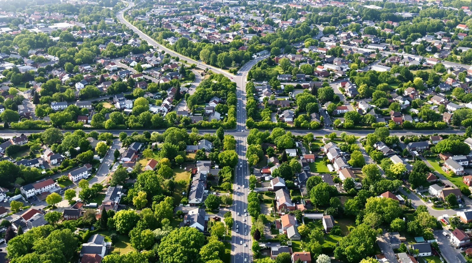
Drive up to the gate of a large township off a state highway near Pune and the geometry announces itself before the security cabin does. The highway runs flat and fast past the boundary wall; a slip lane peels off, a signalised junction slows you, and then you are inside, on a broad tree-lined avenue with a planted median, footpaths on both sides and a bus bay tucked into the kerb. This avenue runs the length of the development — call it the spine. Off it, at intervals, quieter roads turn away toward clusters of buildings, and off those, narrower lanes loop into the actual courtyards where children cycle and cars are parked. The hierarchy is legible. You always know whether you are on a road that is taking you somewhere or a lane that has brought you home.
Now picture the township that got it wrong: one undersized entry shared by ten thousand homes, a single carriageway that doubles as the spine, the distributor and the parking street all at once, and through-traffic from a neighbouring sector grinding past someone's front door. The difference between the two is not landscaping or gate design. It is whether the road network was conceived as a hierarchy — a graded family of roads, each with one clear job, sized for the traffic it will actually carry. A township road network works only when movement is sorted into levels — city connection, township spine, sector distributors, then neighbourhood streets — so that fast through-traffic never has to pass a front gate, and a quiet lane never has to carry a town.
What "road hierarchy" means at township scale
A road carries two things that pull against each other: movement (getting people through, quickly) and place (letting people live, shop, cross, linger). A highway is almost pure movement; a residential cul-de-sac is almost pure place. The whole craft of a road hierarchy is arranging roads on a gradient between those two extremes so each road does one job well instead of every job badly.
This guide deals with the upper tiers of that gradient — the trunk network that stitches a whole township together: the connection to the city, the township spine, and the sector distributors that feed each neighbourhood. The moment a distributor hands a vehicle to a neighbourhood, the lower tiers take over — the collector, local and access streets, their cross-sections, parking and traffic-calming. Those neighbourhood-scale streets are a topic in their own right and are covered fully in street hierarchy explained; this guide deliberately stops at the distributor and hands off to it rather than repeating it. Think of the two guides as nested: the township trunk network gets you to the right neighbourhood, the street hierarchy gets you to the right door. Both sit inside the larger process described in designing a residential township.

The city connection — arterial, entries and the gateway
A township does not exist in isolation; it plugs into a city road that it did not build and cannot control — usually a state highway, a national highway service road, or a major urban arterial. This external connection is the township's lifeline, and it is the tier most often mishandled because the developer's authority ends at the boundary wall.
Three things have to be right. First, the number and spacing of entries. A township of several thousand homes cannot breathe through one gate; peak-hour queues will back onto the highway and become a road-safety problem the moment a school run coincides with the morning commute. Two to four graded entries — a main gateway plus secondary and service entries — spread the load and give emergency vehicles alternatives. Second, the junction where the township meets the arterial must be engineered for the turning movements: a signalised intersection, a grade-separated interchange, or at minimum a properly designed slip-and-merge with deceleration and acceleration lanes, agreed with the highway authority (NHAI, the state PWD, or the urban local body). Third, the gateway itself, where in India the network most often fails. A single boom barrier and a guard cabin throttle a 30-metre arterial down to one lane; the realistic design provides multiple lanes (resident fast-tag, visitor, and a wide service/emergency lane that is never blocked), with queuing space held inside the boundary so it never spills onto the public road.
The township spine — the primary arterial inside the wall
If the township has one road that defines it, it is the spine: the primary internal arterial that runs from the main gateway through the development and connects the major destinations — the central commercial area, the schools, the health facility, the larger parks — to one another and to every sector. The spine is a movement road first. It should carry the longest internal trips at a steady speed, which means generous width, a planted central median that doubles as a safety and shade element, controlled access (sectors join it at managed junctions, individual plots never front directly onto it), and a continuous footpath and ideally a cycle track on both sides.

Geometry matters here. A single straight spine is simple but invites speeding and concentrates all traffic on one line; a loop or a spine-with-loops distributes load, offers redundancy if one stretch is blocked, and shortens the longest trips. Whatever the figure, the governing rule is the same one that defines the whole hierarchy: the spine carries the township's through-movement so that no neighbourhood ever has to. Every metre of through-traffic kept on the spine is a metre kept out of someone's lane.
Sector distributors — feeding each neighbourhood
Between the spine and the neighbourhood streets sits the distributor (or sector) road: the tier that takes traffic off the spine and delivers it to the edge of each residential cluster, then stops. A distributor's job is to distribute, not to invite through-movement — which means it should connect to the spine but not provide a tempting shortcut between two spine junctions or between two sectors. Where a distributor would create a rat-run, planners deliberately interrupt it — a filtered link that passes buses, cycles, pedestrians and emergency vehicles but loops cars back to the spine. This is the single most important move for keeping neighbourhoods quiet, and it is the precise point where the township network hands the vehicle over to the street hierarchy: the distributor brings you to the neighbourhood gate; the collector, local and access streets inside take it from there.
Distributors are also where the township's place functions start to appear in the road section — wider footpaths, street trees, bus stops, the frontage of neighbourhood-level shops and the local park entrance. The movement-versus-place balance tilts steadily as you descend the hierarchy: pure movement on the arterial outside, movement-led on the spine, balanced on the distributor, place-led on the neighbourhood street.
A township road-level table
The figures below are illustrative rights-of-way (ROW), not statutory minimums. Actual widths are set by the applicable Development Control Regulations (DCR), the state township policy and IRC geometric-design standards, and they vary widely with terrain, density and whether the road also carries a transit lane.
| Township road level | Illustrative ROW & primary function | What it connects |
|---|---|---|
| City arterial / highway (external) | 30 m and above; high-speed regional movement, not township-controlled | The township to the city & the wider region |
| Main gateway & entry junction | Multi-lane gate with internal queuing; controlled access & security | The arterial to the township spine |
| Township spine / primary arterial | ~30 m+, divided, median, footpaths & cycle track; township-wide movement & transit | Gateway, town centre, schools, health, major parks & all sectors |
| Sector / distributor road | ~18–24 m; collects & distributes, bus stops, neighbourhood frontage | The spine to each neighbourhood's edge |
| Neighbourhood streets (collector / local / access) | Handed off — see the street-hierarchy guide | The distributor to the home (covered separately) |
Public transport and the transit spine
A township that thinks only about cars has already failed half its residents — the young, the old, the staff, the carless. Public transport at township scale rides the trunk network, and the spine is its natural home. The pattern that works is a transit spine: a bus route that runs the length of the primary arterial, with a loop or two off it so that no home is more than a short, shaded walk — the catchment idea, roughly 400 to 800 metres — from a stop. Stops sit at the junctions where distributors meet the spine, beside the destinations people actually travel to: the town centre, the schools, the gateway and the city-bus interchange just inside it.

The trunk network must reserve, from day one, the things transit needs and cannot be retrofitted cheaply: bus bays cut into the kerb so a stopped bus does not block a lane, a small bus depot or terminal near the gateway with parking and a turning circle, accessible stops with shelter, and — for the larger or future-facing township — a continuous central reservation wide enough to take a dedicated bus lane or feed a metro/BRT corridor later. The Indian failure here is chronic: townships are marketed on connectivity but built for private cars, the promised shuttle quietly stops running, and residents are left dependent on autos and personal vehicles. Designing the transit spine into the road section, and the depot into the phasing, is what makes the difference between a promise and a service.
Junctions, freight, service and emergency routes
At township scale, junctions are where capacity is won or lost. The spine-to-arterial junction is the critical one and usually needs signals or grade separation; spine-to-distributor junctions can often be roundabouts or priority-controlled, which keep traffic flowing and naturally calm speeds. Sight lines, turning radii and pedestrian crossings at every junction follow IRC geometric standards.
Three special networks share the trunk roads and must be planned, not improvised. Freight and service — construction lorries during the build, and later the delivery vans, waste-collection trucks, water tankers, LPG and removal vehicles — need routes sized for them, ideally entering through a service gate and using the spine and distributors rather than threading through narrow lanes. Emergency access — fire tenders and ambulances — drives several hard requirements from NBC 2016: minimum clear widths and turning radii, no dead-ends without a turning head, and at least two independent routes to every cluster so a single blockage never traps a neighbourhood. The filtered links that keep cars out of neighbourhoods must always stay open to emergency vehicles. Get the trunk geometry right and these three networks are nearly free; get it wrong and a fire tender cannot reach a tower.
The road as a corridor — utilities, stormwater and footpaths
A township road is never just a carriageway. Its right-of-way is a corridor that carries far more than vehicles: water mains, sewers, storm drains, power and telecom ducts, street lighting, footpaths, cycle track and a planted verge all share the section, stacked and aligned by a services drawing that is agreed before a single road is built. This is why the trunk roads must be planned together with the township utility networks — the spine and distributors are the very corridors the trunk mains run beneath, and a road built before its services drawing is settled will be dug up within a year.

Stormwater deserves particular attention in the Indian monsoon. The road section must shed water without flooding, and the trunk drains under the spine and distributors are the township's primary drainage arteries — designed to CPHEEO guidance and increasingly to water-sensitive principles (kerbside bioswales, permeable verges, the road draining to a green corridor rather than overwhelming a pipe). The full logic of that is set out in township stormwater planning; the point for the road designer is simply that the cross-section, the camber and the drain are designed as one thing. A footpath that floods every July, or a road that becomes a river, is a road-section failure, not a weather event.
Making it real in India — standards, phasing and the encroachment problem
Two standards bodies govern this work. The IRC (Indian Roads Congress) codes set the geometric design — lane widths, junction radii, sight distances, the cross-section — while the URDPFI Guidelines 2014 and the relevant state township policy set the planning hierarchy and how road land relates to plots and amenities; DCR and RERA-approved layouts fix the legally buildable rights-of-way. Use the illustrative widths in this guide as a starting frame and confirm every figure against the applicable codes.
Phasing is where township road planning is most distinct from neighbourhood-scale work. A township is built over many years and sold in phases, but the trunk roads cannot be built in phases the way plots are. The spine and the primary distributors — and the trunk utility corridors beneath them — should be built early, often before the neighbourhoods they will eventually serve, so that the first residents arrive on finished roads and later construction traffic uses the spine rather than churning through occupied lanes. Building the trunk first costs money before there is revenue to justify it, which is exactly why under-funded townships skimp on it and pay for it forever after.
Finally, the distinctly Indian failure mode: encroachment. A beautifully sectioned road is only as good as its enforcement. Footpaths get parked on, cycle tracks become two-wheeler lanes, service lanes fill with hawkers, bus bays are occupied by parked cars, and the median planting dies for want of maintenance. The trunk network is a long-term asset that needs an owner — the township management company or RWA — with the mandate and budget to keep the carriageway clear, the footpath walkable and the transit spine running. A road hierarchy is a discipline, not a one-time drawing; protecting it is as much a governance task as a design one, and the townships that hold their value are the ones that hold their road sections. Tools like DesignAI can help a planner test spine geometries, entry locations and distributor loops against catchments and movement early — but the hierarchy itself, and the will to defend it, is the enduring design decision.
References
1. URDPFI Guidelines 2014, Ministry of Urban Development, Government of India — road hierarchy, circulation and amenity provisioning.
2. Indian Roads Congress (IRC) — geometric design standards for urban and rural roads (including IRC:86 for urban roads and related junction-design codes).
3. National Building Code of India (NBC) 2016, Bureau of Indian Standards — fire-tender access, road widths and turning requirements.
4. CPHEEO Manual on Stormwater Drainage Systems, Ministry of Housing & Urban Affairs — road-corridor drainage design.
5. The applicable State Integrated Township Policy and Development Control Regulations (DCR) for road rights-of-way and layout approval.
6. IGBC Green Townships Rating System, Indian Green Building Council — transit, walkability and non-motorised-transport credits.
7. Urban Transport in the Developing World / standard urban-planning texts on movement-and-place road hierarchy.
Pair this with street hierarchy explained for the neighbourhood streets below the distributor, and township utility networks for the services beneath the road — or start the whole network in DesignAI.
Export this guide
Related Guides — Deep-dive reading
Visitor Vehicle Management in India: A Professional Guide
The everyday weak point of every society and office gate is not the resident's car — it is the visitor, the cab, the delivery rider and the contractor who must be let in without opening the whole park to anyone. This is the process, not just the hardware: verify at the gate before the boom lifts, park visitors away from resident bays, and never jam the gate a fire tender needs.
SecurityOpen Parking Security in India: Open-Air and Stilt Lots
An open lot and a stilt park feel safer than a basement in daylight, but they are exposed on every side and usually unmanned after dark. Here is how to secure open parking from the boundary in, without ever blocking a fire tender or an escape route.
SecurityBoom Barrier Not Operating (2026): Diagnose a Stuck or Dead Parking Gate Arm
A calm, ordered diagnostic path for a facility or security team when an apartment, office or parking boom barrier will not raise or lower, is stuck up or down, or will not respond — starting with the manual release so a jammed arm never traps a vehicle or blocks a fire lane, then power, trigger, safety loop and mechanical causes, and a clear line between safe checks and technician-only work.
SecurityRelated Tools — Try Free
Visitor Access Planner
Size visitor handling at a gate or reception — lanes needed at peak and the temporary-pass pool.
Visitor FlowGate Access Planner
Size a vehicle gate or boom barrier — lanes needed at peak and the right credential speed (RFID, ANPR, manual).
Gate FlowRainwater Tank Sizer
How big should your rainwater tank be? Computes annual harvest, recommended tank capacity in litres, water-bill savings, and payback — for 10 Indian cities.
RWH Calculator