
Parks and Recreation Planning
The township's parks and active-recreation system — the hierarchy from tot-lot to central park, the sports and clubhouse layer, equitable distribution and the green-blue network
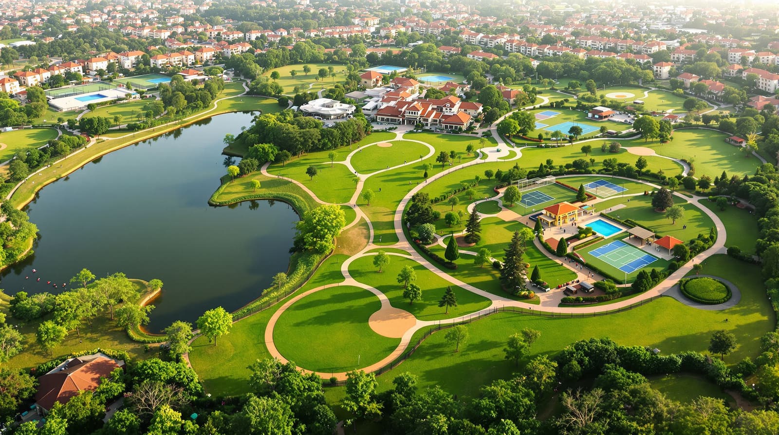
At six in the morning the central park of a Pune township is already busy. A retired couple does its slow lap of the lake while the mist still hangs over the water; a knot of teenagers has claimed the basketball half-court; somewhere behind the bamboo screen a dozen people in white are mid-Surya Namaskar on the events lawn. By eight the toddlers have taken over the tot-lots tucked between the towers, each one a ninety-second walk from a front door, and by evening the cricket nets at the sports complex will have a queue. The clubhouse — pool, gym, indoor badminton, a hall that will host three birthday parties this weekend — is the single image the developer put on every hoarding from the expressway to the airport.
None of that happened by accident, and none of it is "landscaping." It is a designed system: a graded family of green spaces and active-recreation facilities, sized to the township's population, distributed so that no home is stranded far from a green, and stitched into a continuous network you can walk and cycle. Get it right and the park system becomes the township's identity and its value driver; get it wrong and you are left with manicured leftover land that nobody uses and a clubhouse that empties out after the launch. A township's recreation plan is not a patch of grass at the entrance — it is a population-sized hierarchy of green and active spaces, equitably distributed and linked into one network, with the central park as its civic heart.
Recreation at township scale: a hierarchy, not a park
A single neighbourhood needs a hierarchy of open space — the tot-lot, the housing-cluster green, the neighbourhood park. We treat that scale in detail in open space planning for residential layouts, and you should read it as the foundation. A township is different in kind, not just in size. It contains many neighbourhoods, and above their local greens it must provide the spaces that only make sense when thousands of people share them: the large central park, the sports complex, the stadium-grade cricket ground, the township clubhouse. The planning job is to nest these scales so that each level of green serves the right catchment.
Think of recreational open space in four tiers. The tot-lot or housing-cluster green is the smallest — a few hundred square metres of play equipment and shaded seating serving the homes immediately around it, reached without crossing a vehicular road. The neighbourhood park serves one residential pocket of a few thousand people within a five-minute walk; it carries a walking loop, a children's play area, a lawn and trees. The sector or community park serves a cluster of neighbourhoods and is large enough for organised play — a multipurpose ground, courts, a community hall. At the top sits the central township park, the green heart that the whole development shares, holding the lake or water body, the events lawn, the long jogging and cycling loop and, often, the clubhouse and sports complex.
Linking all of them is the green-blue network: a continuous system of tree-lined walkways, cycle tracks and the township's stormwater drains, swales and water bodies, so the parks are not islands but a connected armature you can move through. The blue layer — lakes, recharge ponds, the storm network doubling as linear green — is detailed in blue-green infrastructure for Indian developments; at township scale it is what turns a collection of parks into a system.

The active-recreation layer: beyond passive parkland
Passive parks — lawns, walking loops, shaded seating — are necessary but not sufficient. A township sells itself, and earns its premium, on the active-recreation layer that sits on top: the facilities people use to play, train, swim and gather. This is a distinct programme, and it needs deliberate land, not whatever is left after the buildings are pegged out.
The core elements recur across Indian townships. A sports complex anchors it — typically a clubhouse building plus outdoor facilities. Inside the clubhouse: a swimming pool (and increasingly a separate kids' pool), a gymnasium, indoor badminton and table-tennis, a multipurpose hall, sometimes squash and a small library or co-working lounge. Outside: courts for badminton, basketball, tennis and lawn games, and — this being India — cricket, whether full practice nets, a turf or matting pitch, or a proper community ground. A jogging and cycling loop of a known length (people like to count their kilometres) threads the central park. And the human bookends matter: a generous children's play zone with age-graded equipment and soft fall surfacing, and a senior fitness and wellness zone — outdoor gym equipment, a yoga deck, a reflexology path, shaded benches — because a township's residents age in place.
The clubhouse deserves singling out. In the Indian market it is the headline amenity, the thing the sales team photographs and the buyer asks about first. That makes it tempting to over-build at launch and then under-program — a magnificent hall that hosts nothing, a pool nobody is rostered to maintain. The discipline is to size the active layer to the population it will eventually serve (not Phase 1 alone), phase it so early residents are not left with a fenced-off construction site, and write its operating model before the first brick. National Building Code 2016 governs the buildings themselves — assembly-occupancy egress for the hall and pool deck, structural and fire provisions — so the clubhouse is a real building project, not a folly.

Provisioning by population: how much green, and where
How much recreational open space does a township owe its residents? The reference point in Indian practice is the URDPFI Guidelines 2014 (Urban and Regional Development Plans Formulation and Implementation), which set open-space and amenity standards by population. These are planning-level benchmarks for public provision, and they should be used honestly: they are guidelines, not a building code, the figures vary by plan type and by the state or local development control rules that ultimately bind a project, and a private township will reconcile them with its own RERA-declared common areas and the relevant state integrated-township policy. Treat the numbers below as the order of magnitude and the hierarchy logic to design to, then confirm against your local norms.
URDPFI broadly frames "organised green and recreational space" at roughly the order of 10 to 12 sq m per person across the levels of the hierarchy, with that total split between the small play spaces, neighbourhood and community parks, and district or city-level parks. The useful idea is not a single headline ratio but the graded provision — small greens at high frequency close to homes, large parks at low frequency serving wide catchments. The table sets out a working hierarchy you can size a township against; calibrate the exact areas to your population, density and the green-cover targets you commit to under schemes such as IGBC Green Townships.
| Recreation type | Typical catchment / population served | Indicative size | Walk / access |
|---|---|---|---|
| Tot-lot / cluster green | A housing cluster, ~1,000–2,000 people | ~0.2–0.5 acre | 1–3 min, no road crossing |
| Neighbourhood park | One neighbourhood, ~5,000 people | ~1–2 acres | ~5 min walk |
| Sector / community park & ground | A group of neighbourhoods, ~15,000–25,000 | ~5–10 acres | ~10 min walk / short cycle |
| Sports complex & clubhouse | Whole township | ~3–8 acres (built & open) | Cycle / short drive |
| Central township park | Whole township & visitors | ~15–40+ acres | The shared destination |
| Green-blue corridor network | Links all of the above | Linear, along drains & streets | Continuous walk / cycle |
Distribution and equity: every home near a green
Provisioning the right total area is half the job; distributing it fairly is the other half, and it is where most townships quietly fail. The temptation is to consolidate green into one spectacular central park beside the entrance and the sales gallery, leaving the back phases with token verges. The principle that prevents this is simple and measurable: every home should be within a short, safe, walkable distance of a green — a tot-lot or cluster green within a couple of minutes, a neighbourhood park within five. Recreation should be planned as structuring framework first and the buildings fitted around it, not designated from the residue once the saleable plots are maximised.
This is where recreation planning fuses with movement planning. A park you cannot walk to safely is a park for the few who drive; the green network only works if the walking and cycling routes that reach it are continuous, shaded and free of hostile road crossings. That logic — the five-minute walk, the safe pedestrian route, the destination at the end of it — is the heart of walkable neighbourhood design, and a township should apply it across its whole green system, not just within one pocket. Equity also means programming for everyone: the toddler and the grandparent, the cricket-mad teenager and the morning-walk regular, the festival crowd and the quiet reader. A recreation plan that serves only one demographic is under-distributed even if the area maths checks out.

Multi-use, programming and the climate test
Land is expensive, so the best township greens earn their keep several times over. The central lawn is the maidan — yoga at dawn, cricket on Sunday, the Diwali mela, the Independence Day flag-hoisting, the open-air screening, the wedding-season marquee. A school ground, planned with a separate after-hours entrance, can serve the township's evening and weekend sport once the bell rings; the school itself is part of the township's social infrastructure, and we treat that provisioning in school planning for townships. The community hall flips from morning senior-citizen activities to evening classes to weekend functions. Designing for this multi-use programming — flexible surfaces, robust services, clear booking and governance — is what separates a living recreation system from a photogenic but empty one.
In India the climate is the ultimate usability test. A treeless lawn baking under a 42-degree April sun is, in practice, unusable from ten to five; a path with no canopy is walked by nobody. So shade and water are not decoration, they are the enabling infrastructure of usability — generous tree planting along every loop, pergolas and pavilions, water bodies and fountains for cooling, and surfaces that drain rather than flood. The monsoon imposes the second test: the park system should hold and slow stormwater rather than turn to a swamp, which is why the recreation plan and the drainage plan are the same plan, coordinated with the township's wider stormwater strategy. Water-sensitive design — swales, rain gardens, permeable paths, recharge ponds doubling as landscape features — makes the green network resilient; see water-sensitive urban design for the techniques.
The central park as identity and value
Every successful Indian township has a green heart that residents name and visitors photograph. Magarpatta City in Pune built its identity around a large central park and a deliberately green, walkable core; Aranya at Indore is remembered for its community structure; the new-town experiments at Naya Raipur and GIFT City placed civic green at their centre. The lesson across them is consistent: the central township park is the development's address, its civic stage and its value driver. A well-made green heart — lake, events lawn, the long signature loop, the clubhouse — lifts the value of every plot that looks onto it and gives the township a memory and a name. It is the single most legible expression of quality a developer can build, and the one buyers price in.

That value is only real if it survives the handover. Recreation is the most maintenance-hungry part of a township — lawns need mowing, pools need plant and lifeguards, trees need years to mature, courts need resurfacing. The governance question must be answered before launch, not after: who owns the central park and the clubhouse, who funds the recurring cost, and through what body? In gated Indian townships this usually lands on a township management company or a federation of RWAs, drawing on a maintenance corpus and monthly charges. Phasing matters too — early residents resent paying for a clubhouse that is still a foundation pit, so the recreation programme should be sequenced to deliver usable greens and a basic clubhouse early, then scale. And there is an honest tension between developer provision and public access: a private township internalises its parks for its residents, which is good for governance and accountability but withdraws green from the wider city. The mature answer treats the recreation system as a long-term operating commitment, written into the township's management constitution, not a one-time capital flourish. This whole chain — sizing, distribution, programming, governance — is the work of the township design process set out in the pillar guide, designing a residential township.
References
1. URDPFI Guidelines 2014 (Urban and Regional Development Plans Formulation and Implementation), Ministry of Urban Development, Government of India — amenity, open-space and social-infrastructure standards by population.
2. National Building Code of India 2016 (NBC 2016), Bureau of Indian Standards — Part 4 fire and life safety, assembly-occupancy provisions for clubhouses, halls and pools.
3. The relevant State Integrated Township Policy / Township Development Scheme (for example Maharashtra, Haryana, Uttar Pradesh) — minimum area, open-space and amenity obligations for private townships.
4. CPHEEO Manual on Stormwater Drainage Systems, Ministry of Housing and Urban Affairs — coordinating park drainage and the green-blue network.
5. IGBC Green Townships Rating System, Indian Green Building Council — green-cover, open-space and recreation credits at township scale.
6. IRC standards for urban roads and pedestrian/cycle facilities — safe walking and cycling access to the recreation network.
7. Urban Design and Planning of public open space — a standard planning text on park hierarchy and recreation provisioning.
Plan the township's green and active-recreation system alongside its community facilities and the neighbourhood-scale open space hierarchy — and sketch and size the whole park network with DesignAI.
Export this guide
Related Guides — Deep-dive reading
Designing Adaptable & Universal-Design Homes
Accessibility, Aging-in-Place, and the Multi-Stage Family — Code, Anthropometrics, and Plan-Stage Discipline for Indian Residential Architects
Room PlanningWhy Landscape Architecture Matters More Than the Building
How the green around, above and beyond your home out-cools, out-drains and out-appreciates the structure itself — at every scale from balcony to city.
LandscapeSchool Planning Inside Townships
Schools as township amenities — how many of what type by population, the walk-to-school catchment, safe siting away from arterials, the school-park pairing and safe routes
Township PlanningRelated Tools — Try Free
Cross-Ventilation Analyzer
Estimate airflow and air changes per hour (ACH) from room size, window areas, layout, and local wind — with NBC 2016 Part 8 compliance check.
Ventilation CalculatorGarden Planning Toolkit
Get a tailored garden plan — planting layers, Indian species, features and a checklist — from your climate, space, sun and goals.
PlannerRainwater Tank Sizer
How big should your rainwater tank be? Computes annual harvest, recommended tank capacity in litres, water-bill savings, and payback — for 10 Indian cities.
RWH Calculator