
Township Stormwater Planning
Keeping a township dry while recharging the aquifer — reading the watershed, the drainage network to a safe outfall, detention and the central lake, and the sponge township
The first monsoon after handover is the township's real opening night. The roads are done, the homes are sold, the parks are green — and then a cloudburst drops 90 millimetres in two hours. In a township that was planned for water, almost nothing happens: the roadside swales fill and trickle, the storm channels run brown but full, the central lake rises a metre and holds, and by evening the streets are walkable again. The aquifer is a little fuller than it was that morning. In a township that was not planned for water, the same cloudburst sends a brown river down the spine road, drowns a basement parking, backs up into the ground-floor flats nearest the old drain line that somebody decided to build over, and pushes a wall of water onto the village downstream that never used to flood until this township existed.
That contrast is not about luck or rainfall. It is about whether a few hundred acres of newly hard, newly built land were planned to manage their own rain — or were planned only to get the water off-site as fast as possible and let the neighbours deal with it. Township stormwater planning is the discipline of managing rain where it falls — slowing it, storing it, soaking what you can into the ground, and only then conveying the rest safely to a natural outfall — so the township stays dry, the aquifer is recharged, and the city downstream is never flooded by your runoff.
What stormwater means at township scale
A single plot worries about getting water off its roof. A township is a watershed. When you cover tens or hundreds of acres with roofs, roads, podiums and paving, you convert land that used to absorb most of its rain into land that sheds almost all of it — runoff coefficients jump from roughly 0.1–0.2 for open ground to 0.7–0.95 for built surfaces, and the rain that used to soak in over hours now arrives at the low point in minutes. That changed hydrology is the township's to manage, not the downstream village's.
So stormwater at this scale is a trunk system, parallel in logic to the township's water supply and sewerage but flowing the other way — collecting from everywhere and concentrating toward one or two outfalls. It is hard drainage engineering: a sized, hierarchical network of channels, drains and trunk lines, plus detention and recharge structures, designed to a chosen storm. This guide is about that hard network. It is the close cousin of two landscape-led approaches you should read alongside it — water sensitive urban design and blue-green infrastructure — which treat water as a designed landscape that the township lives with rather than a nuisance to be piped away. They complement this guide rather than replace it: WSUD and blue-green give you the swales, lakes and soft systems; this guide gives you the network hierarchy, the sizing and the safe outfall that keep the place engineered against the design storm. And while it shares trenches and a corridor with the township's other lines, stormwater is emphatically the separate drainage system within the broader township utility networks — never mixed with sewage. The whole subject sits inside designing a residential township.
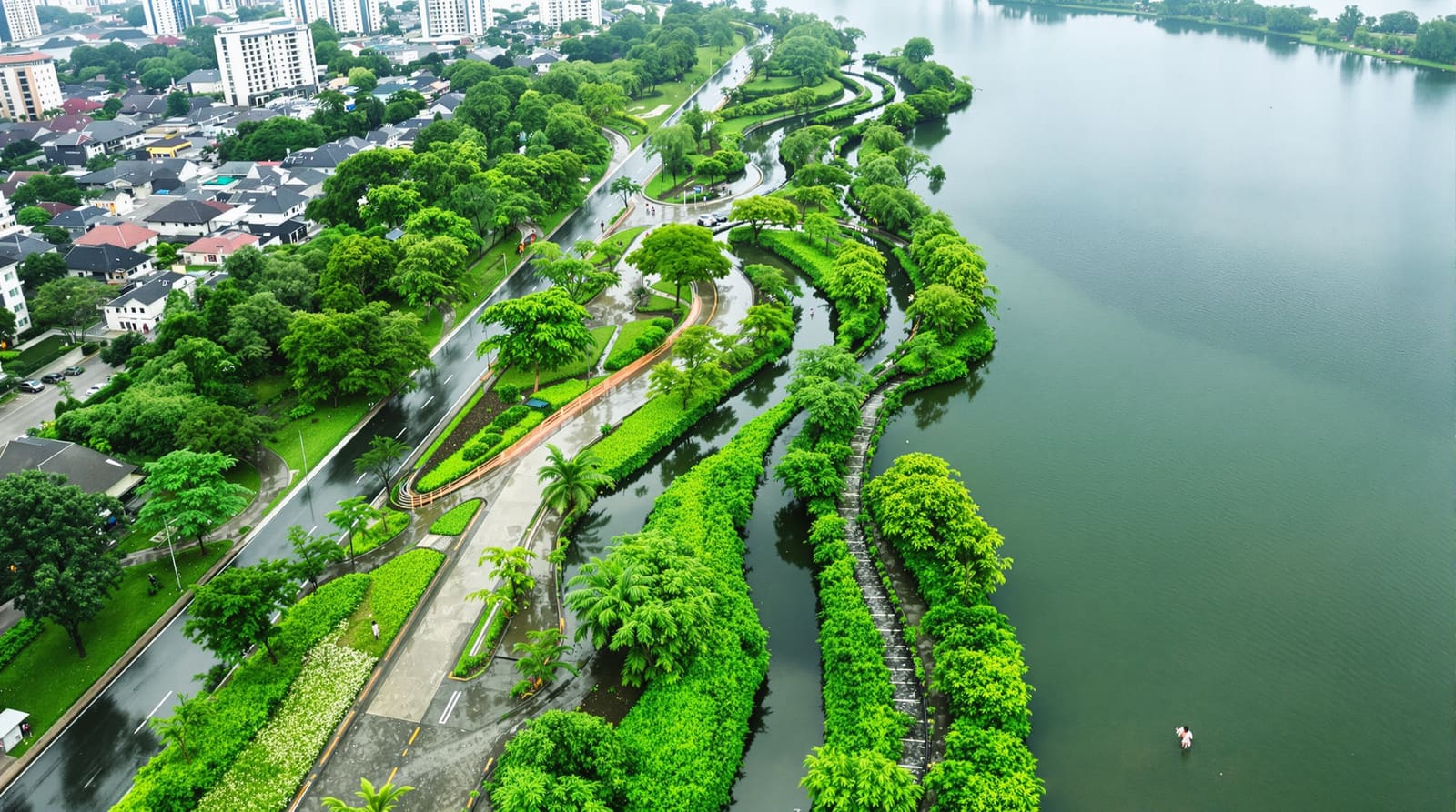
Read the watershed before you draw a single drain
Every site already has a drainage logic written into it by gravity. Water has been finding its way across that land for centuries, collecting in a natural channel — in most of India, a nallah — and leaving at a low point. The single most important and most neglected act in township stormwater planning is to map that natural drainage first: the contours, the catchment boundaries, the existing nallahs and streams, the natural ponds and tanks, and the point where water has always left the site.

The principle is simple and almost always violated: work with the natural drainage, do not build over it. The existing nallah is not waste land waiting to be reclaimed for an extra row of villas — it is the township's primary trunk drain, already sized by nature for the catchment, already at the right level, already heading to the right outfall. Preserve it, widen it if your added runoff demands, naturalise its banks, and route your network into it. The same goes for the existing tanks and low spots: they are the detention basins the land already chose. Building over a nallah or filling a tank does not remove the water; it only removes the place the water was going to go, which it then finds again — through somebody's living room. India's urban-flooding crisis is largely this single mistake repeated at city scale: Bengaluru's flooding traces directly to the building-over of its interconnected tank cascade and the encroachment of the rajakaluves (storm channels) that linked them; Chennai's catastrophic 2015 flood was sharpened by construction across the Pallikaranai marsh and the natural floodplains; Mumbai floods when the Mithi river's choked, encroached channel cannot carry a high tide and a cloudburst at once. A township is small enough that it has no excuse — the encroacher and the planner are the same organisation.
The drainage network hierarchy
A township stormwater system is a tree, and like the township road hierarchy it works because each tier hands to the next without overloading it. Water enters everywhere at the surface and concentrates downward toward the outfall.

At the top of the tree, by area, are the surface collectors: the road camber and kerb that shed water to the edge, the roadside drains running along every street, and — in a township that takes recharge seriously — vegetated swales that collect, slow and partly infiltrate before they pass anything on. These feed secondary drains, larger covered or open channels that gather several streets' worth and run along the neighbourhood spines. Secondary drains discharge into the primary trunk drains — the main arteries, almost always following the natural valley lines and ideally the preserved nallah itself — which carry the whole catchment's flow to the outfall, the single controlled point where the township returns water to a natural system. The discipline is that flow only ever moves down the hierarchy, gradients are continuous, and no tier is asked to carry more than it was sized for. Get the levels wrong — a trunk drain laid flatter than its silt-carrying minimum, or an outfall sitting higher than the channel feeding it — and the network backs up from the bottom no matter how generously the top was built.
Sizing for the design storm
How big should the drains be? You size to a design storm — a rainfall event of a chosen intensity and duration that the system is built to handle without flooding. Engineers read this off Intensity-Duration-Frequency (IDF) curves, which say, for a given place, how intense rainfall gets for a given duration and a given return period. A drain designed for a 1-in-2-year storm will be overwhelmed every couple of years; a primary trunk and outfall might be designed for a 1-in-25 or 1-in-50-year event because the consequence of their failure is catastrophic. The CPHEEO stormwater drainage manual is the standard Indian reference for these methods, the rational-formula approach to peak flow, and the return periods appropriate to different parts of the network.
Two honest cautions belong here. First, the runoff coefficient you assume is doing enormous work — assume the township stays half-pervious when it will end up nine-tenths paved, and every drain is undersized from day one. Second, the IDF curves most Indian cities still use were built from historical records, and the monsoon is no longer behaving historically: short, violent cloudbursts that deliver a month's rain in an afternoon are getting more frequent. Prudent townships now add a climate-change buffer — designing trunk infrastructure and the outfall for a heavier storm than the historical curve strictly requires. The exact margin is a judgement, not a settled number, and it should be qualified as such rather than presented as a code value; but the direction is clear, and a township meant to last fifty years should not be sized only for the last fifty years' rain.
Detention, retention and holding the peak
Even a generously sized network has a problem: if every township sheds its peak flow downstream at the same instant the storm hits, the cumulative wave drowns the city below. The answer is to hold the peak back — to flatten the township's hydrograph so it releases water slowly over many hours instead of all at once.

This is the job of detention and retention. A detention basin is normally dry; it fills during a storm, holds the surge, and drains down slowly through a restricted outlet over the following hours — its whole purpose is to delay. A retention pond holds water permanently — the central lake that so many good Indian townships build, which doubles as amenity, microclimate cooler, fire reserve and the visual heart of the parks and recreation plan while quietly doing serious hydraulic work. Magarpatta and Lavasa both built central water bodies that earn their keep this way. The principle is that the township's controlled release rate to its outfall should not exceed roughly what the land discharged before development — the township absorbs its own added burden rather than exporting it. A central lake or a chain of basins sited on the natural low points is the cleanest way to deliver that, and it is far cheaper to design in from the master plan than to retrofit after the homes are sold.
The sponge township — recharge and soak
Detaining water still eventually lets it leave. The deeper ambition is to keep a large share of it on site for good, by soaking it into the ground — the "sponge city" idea, applied at township scale. This matters doubly in India, where the same regions that flood in July run their borewells dry by April; every litre infiltrated in the monsoon is a litre of aquifer for the dry season.

A sponge township is built from many small interventions: permeable paving in parking courts and low-traffic streets so rain soaks rather than sheets; bioswales along roads that infiltrate as they convey; recharge pits and recharge wells that take roof and road runoff down past the surface clay to the water table; rooftop rainwater harvesting on every building feeding either storage or recharge; and parks designed as shallow flood-tolerant basins that double as infiltration fields. Most Indian states and the NBC already mandate rainwater harvesting above a plot size — a township should treat that floor as the start, not the target. The sponge approach is exactly where this hard-drainage guide hands over to the blue-green and water-sensitive design thinking: the more rain the soft systems soak up, the smaller and safer the engineered network and outfall need to be. The two work as one budget — what the sponge absorbs, the pipes never have to carry.
One non-negotiable: keep stormwater separate from sewage
Stormwater and sewage must travel in two entirely separate systems. Combined systems — where one set of pipes carries both — overflow raw sewage into rivers and lakes during every heavy storm, because the foul flow is suddenly multiplied by rainwater the treatment plant cannot handle. Modern Indian practice and the CPHEEO manuals specify separate systems, and a township built from scratch has no reason to do otherwise. Stormwater is treated as a clean-enough resource to recharge and to feed a lake; mixing a drop of sewage into it poisons that entire premise. This separation is one of the cardinal rules of the township's utility networks, and it must be policed on site through construction — a single misconnected drain can quietly contaminate the lake the whole township swims past.
What each stormwater move does
| Stormwater move | What it does for the township |
|---|---|
| Map the watershed & preserve the nallah | Uses gravity's own drainage; avoids building over the channel that water will find anyway |
| Roadside drains & swales | Collect at the surface where rain falls; swales slow & infiltrate before conveying |
| Secondary & primary trunk drains | Concentrate flow downhill along valley lines toward one safe outfall |
| Size to the design storm + buffer | Network carries the chosen IDF event; a climate margin guards against intensifying cloudbursts |
| Detention basins | Hold the storm peak & release slowly so the township & downstream city do not flood |
| Central lake / retention pond | Permanent storage that flattens the peak & serves as amenity, fire reserve & microclimate |
| Permeable surfaces, recharge wells & harvesting | Soak rain into the aquifer; shrink the engineered network & refill dry-season groundwater |
| Separate stormwater from sewage | Keeps runoff clean enough to recharge & feed the lake; prevents storm-driven sewage overflow |
| Controlled outfall to a natural body | Returns water at a rate no greater than pre-development; accepts downstream responsibility |
| Desilting & maintenance regime | Keeps capacity real — a silted drain has the hydraulics of no drain at all |
The outfall and downstream responsibility
Every township stormwater system ends at an outfall — the point where water rejoins a nallah, river or lake. Two things must be true there. The outfall must be at a level and capacity that can actually accept the flow, including at high river stage or high tide, so the network does not back up at its own exit. And — the ethical and increasingly the legal point — the township's controlled release must not exceed what the land shed before it was built. A township is not entitled to convert its acres of new roof and road into a flood it pours onto whoever lives below. That downstream responsibility is precisely what detention, retention and recharge exist to honour; without them, a perfectly engineered internal network simply delivers the township's amplified flood very efficiently to the next settlement. RERA disclosures, environmental clearances and IGBC Green Township criteria increasingly expect this no-net-increase logic to be demonstrated, not assumed.
In India: lessons, encroachment and maintenance
The clearest lessons are written in the floods. Chennai, Bengaluru and Mumbai did not flood because it rained — they flood because their natural drainage was built over, their tank cascades severed, their nallahs and rajakaluves encroached and choked, and their wetlands paved. A greenfield township is handed the chance to not repeat any of that — to keep its nallah open, its low points as lakes, its catchment connected. Whether it takes that chance is a governance question as much as an engineering one. The protection of natural water bodies has to survive the entire build-out, when the pressure to fill the inconvenient tank for a few more saleable units is at its highest, and it has to survive handover to the resident body that inherits the system.
That inheritance is where most systems quietly fail. A stormwater network is only as good as its least-maintained drain. Drains silt up between monsoons; swales clog with leaves and litter; recharge wells cake over; the lake's outlet jams. A drain at half capacity behaves, in the storm that matters, like a drain at no capacity — and the township that engineered everything correctly floods anyway because nobody desilted the trunk channel in May. So the master plan must hand the township management body or RWA not just a network but a maintenance regime: a pre-monsoon desilting calendar, clear access along every channel, a named owner for the lake and the outfall, and the budget to do it. The encroachment crisis and the maintenance crisis are the same disease at different speeds — both are the slow forgetting that water will always come back for the space you took from it.
References
- CPHEEO, Manual on Storm Water Drainage Systems and Manual on Sewerage & Sewage Treatment (Ministry of Housing & Urban Affairs, Government of India) — design storms, return periods, separate-system practice.
- URDPFI Guidelines 2014 (Ministry of Urban Development) — physical infrastructure, drainage and water-body provisioning at settlement scale.
- National Building Code of India (NBC) 2016, Bureau of Indian Standards — building services, plumbing and rainwater harvesting provisions.
- IGBC Green Townships Rating System (Indian Green Building Council) — stormwater management, runoff control and water-body protection criteria.
- Indian Roads Congress, road drainage standards (IRC: SP and related codes) — kerb, camber and roadside-drain practice for township streets.
- Central Ground Water Board, guidelines on artificial recharge and rainwater harvesting — recharge wells, infiltration and aquifer replenishment.
- Relevant State Integrated Township Policy and the applicable city Master Plan / drainage master plan — local catchment, nallah and outfall obligations.
Read this alongside water sensitive urban design and blue-green infrastructure for the landscape-led side of the same water — and let DesignAI help you visualise a township that stays dry while it recharges its own aquifer.
Export this guide
Related Guides — Deep-dive reading
Stormwater & Surface Drainage in India: Getting Rain Off Your Roof, Paving and Plot
A homeowner's guide to stormwater drainage — sizing roof outlets and downpipes for monsoon rainfall, surface channels and catch basins, grading the plot away from the house, and where the water finally goes, kept firmly separate from your foul drains.
PlumbingPercolation Tanks & Ponds in India: Recharging Groundwater at Plot, Farm and Watershed Scale
A professional guide to percolation tanks — impounding monsoon runoff in a shallow surface basin so it slowly infiltrates and recharges the aquifer. How they work, where they suit, siting, indicative sizing, silt management and how they relate to check dams.
PlumbingParking Drainage and Stormwater in India: Channels, Oil Separators and Rainwater (2026)
How to get water OFF and OUT of a car park safely, and put it to use — surface falls to the drains, the critical grated channel at the foot of every ramp, trench vs point drains, the oil and petrol interceptor that keeps runoff clean, silt traps, municipal stormwater vs on-site recharge, rainwater harvesting from the parking catchment, and monsoon flood resilience for basements.
ParkingRelated Tools — Try Free
Rainwater Tank Sizer
How big should your rainwater tank be? Computes annual harvest, recommended tank capacity in litres, water-bill savings, and payback — for 10 Indian cities.
RWH CalculatorCross-Ventilation Analyzer
Estimate airflow and air changes per hour (ACH) from room size, window areas, layout, and local wind — with NBC 2016 Part 8 compliance check.
Ventilation CalculatorRainwater From Parking Calculator
Indicative harvestable rainwater from a parking catchment, from the area, annual rainfall and surface runoff.
Water Calculator