
Walkable Neighborhood Design
Designing a neighbourhood people want to walk in — the 15-minute neighbourhood, Speck's walkability, the pedestrian network, traffic calming and shade for the Indian climate
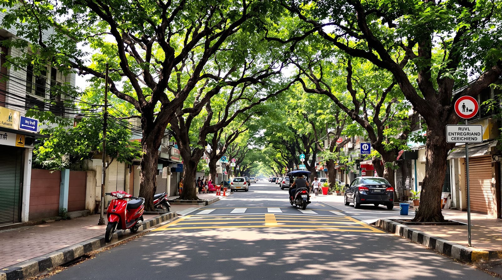
It is 6.30 in the evening in a layout on the edge of a fast-growing Indian city. The light is soft, the worst of the heat has lifted, and the street should be full of people — children testing the limits of how far they can wander, elders on their slow constitutional, somebody walking to the corner kirana for coriander and curd. Instead it is empty. The footpath, where it exists, is a broken ribbon of cracked tiles interrupted by a transformer, a parked scooter, a heap of construction sand and a drop into an open drain. So everyone walks in the road, hugging the edge, stepping aside as cars accelerate down a straight, wide carriageway that all but invites speed. The nearest shop is a fifteen-minute trudge along a route with no shade and one terrifying crossing of a four-lane road with no signal and no refuge.
Half a kilometre away, an older colony tells a different story. The streets are narrower and bend gently, plane-tree and gulmohar canopy meets overhead, the footpath is continuous and wide enough for two people and a pram, and a kirana, a chemist, a tiny park and a bus stop all sit within a comfortable stroll. People are out — and because people are out, it feels safe to be out. The difference between the two places is not money or climate or culture. It is design. A neighbourhood is walkable not by accident but by deliberate design — when the daily destinations are close, the path to them is continuous and shaded, and the street is engineered to make walking useful, safe, comfortable and interesting.
The 15-minute neighbourhood
The single most useful idea for a layout planner is Carlos Moreno's 15-minute city — the principle that the things people need most days should lie within a short walk or cycle of home. Translated to the scale of a residential layout, it becomes a 15-minute (often a 10-minute, or even 5-minute) neighbourhood: a child's school, a park, a place to buy daily groceries, a clinic or chemist, and a transit stop, all reachable on foot without crossing a hostile barrier.
The discipline this imposes is one of proximity and arrangement. A comfortable walking distance for daily errands is commonly taken as around 400 to 800 metres — roughly a five-to-ten-minute walk — which is, not coincidentally, the catchment Clarence Perry used a century ago when he sized his Neighbourhood Unit around a primary school. If your layout scatters its amenity plot, its commercial frontage and its parks to wherever the leftover land happened to be, you have a subdivision but not a neighbourhood. If you place them where the most people can reach them on foot — near the centre, near where paths converge, near the transit edge — you have given residents the option to leave the car at home. The arithmetic of what land you reserve and where belongs to the layout planning principles and the broader pillar process; what matters here is that the walk to each destination is one a real person will actually choose to take.

What makes a walk worth taking — Jeff Speck's four conditions
Proximity is necessary but not sufficient. A shop can be 300 metres away and still feel unreachable. In Walkable City, Jeff Speck distils decades of urban-design thinking into a deceptively simple test: a walk has to satisfy four conditions, and it fails if any one is missing. It must be useful, safe, comfortable and interesting.
A useful walk is one with a real destination at the end of it — which loops straight back to the 15-minute idea and to mixed use. A safe walk is one where you are protected from traffic and where the path itself does not put you at risk — continuous footpath, slow vehicles, good crossings, no open drains. A comfortable walk is one where the body is at ease: shade against the sun, a footpath wide enough not to feel exposed, an enclosing street wall rather than a windswept expanse of carriageway. An interesting walk has something to look at — active ground-floor frontages, doorways and verandahs, a changing edge, the small theatre of other people doing things. A blank compound wall for 200 metres fails the interest test even if it passes every other. These four conditions are the lens for everything that follows: each design move below is really a way of satisfying one or more of them.
The pedestrian network: continuity, permeability and short blocks
People walk along a network, not along individual streets, and the network either holds together or it does not. The first virtue is continuity — an unbroken footpath that does not vanish at every gate, electricity pole or property line. In India the footpath is too often treated as residual space, the strip left over after the carriageway and the services have taken what they want; the result is the encroached, discontinuous, obstacle-strewn path that pushes people into the road. A walkable layout treats the footpath as a designed object with a guaranteed clear width, with the utilities, the trees and the parking each given their own zone so none of them eats the walking space. (How those zones share the cross-section is the engineering subject of the street hierarchy guide — the point here is simply that the pedestrian gets a continuous, protected lane of their own.)
The second virtue is permeability and short blocks, an insight associated with Jane Jacobs and central to New Urbanism. A fine grid of short blocks gives walkers many routes and direct lines to where they are going; the long superblock, ringed by a fast road and entered through a single gate, forces every short trip into a long detour and is fatal to walking. Connected, frequent crossings at junctions matter as much as the footpaths between them — a perfect path that dumps you at an un-crossable road has failed. And good designers respect the desire line: the diagonal shortcut people will take whether or not you paved it. Plan the cut-through, the mid-block pedestrian link between two streets, the gap in the park boundary where everyone enters anyway, and you get a network that matches how people actually move. Kevin Lynch's reminder in The Image of the City is the same one in another key: a legible network of clear paths, edges and nodes is one people trust enough to walk.

Slowing the car: traffic calming for residential streets
On a local residential street the pedestrian and the car share space, and the car must be the guest. The aim is not to ban vehicles but to design the street so that driving fast feels wrong — so that 20 to 30 km/h is the natural speed, the speed at which a collision is survivable and a driver can stop for a child. This is slow-speed, self-enforcing design, and it is built into geometry rather than bolted on as a speed-breaker afterthought.
The toolkit is well established. Narrowing the carriageway — keeping local-street running width genuinely tight rather than generous — is the most powerful single move, because a wide straight road reads as permission to accelerate. Raised crossings and raised junction tables lift the pedestrian to footpath level and make the car climb to meet them, reversing the usual hierarchy. Chicanes and gentle bends break the long straight sight-line that invites speed. Street trees close to the kerb create a sense of enclosure and visual friction that measurably slows drivers, while doing the shading work the climate demands. None of this needs to be ugly: a well-calmed Indian residential street looks like a pleasant tree-lined lane, not an obstacle course of yellow-painted humps. The radial picture below shows how these factors reinforce one another — connectivity, mix, density, safety, shade, an active edge and good crossings are not a menu to pick from but a set that works together.


Shade is not optional: the walkable street as a cool corridor
In most of India, for much of the year, the binding constraint on walking is not distance — it is heat. A 600-metre walk that is delightful in a temperate city is a punishing exposure to the sun here at two in the afternoon. This is why Jeff Speck's "comfortable" condition is, in the Indian context, very largely a question of shade, and why shade is non-negotiable: design the walking route as a cool corridor or people simply will not use it once the family has a car and an air-conditioned cabin to retreat into.
The primary tool is the tree canopy — a continuous avenue of the right native or climate-adapted species, planted close enough and grown large enough that their crowns meet over the footpath. This requires planning from day one: adequate tree pits, soil volume and clearance from underground services, and a species palette chosen for shade and for survival, a subject the residential site-planning and landscape guide treats in depth. Where buildings front the street, arcades, deep verandahs and projecting upper floors give built shade — the colonnaded shopping streets of older Indian towns are a centuries-old answer to exactly this problem. Orienting the main pedestrian spines to catch shade and the prevailing breeze, keeping building edges close enough to shadow the path morning and evening, and using light-coloured, non-reflective paving all turn the walk from an ordeal into something pleasant. A shaded route is a walked route.
The daily destinations and the safety dimension
A walk needs somewhere to go. Mixing the daily destinations into the fabric — a kirana or small grocery at the corner, the neighbourhood school within its own walking catchment, a park and play space, the transit stop — is what makes the whole network useful. This is the Jacobs and New Urbanism point about fine-grained mixed use, and it is where this guide hands off to the anatomy of a good neighbourhood, which deals with the social and placemaking life those destinations create. The transit stop deserves special emphasis: the last-mile walk to transit is the link that decides whether the bus or metro is a real option, so the pedestrian network should funnel cleanly and shadily to it, with a safe crossing and a sheltered, lit place to wait.
The other half of feeling able to walk is the safety dimension, and it has two parts. The first is traffic safety, dealt with above. The second is personal safety, and here Jane Jacobs's phrase — eyes on the street — is the design principle. A street overlooked by windows, doors, verandahs and balconies, with people coming and going, is self-policing in a way no patrol can match; a street walled in by blank compound boundaries is not. So orient homes and shopfronts to face and animate the street rather than turning their backs to it. Layer on good, even lighting at the pedestrian's scale — warm, continuous, designed for the footpath and not just the carriageway — so that the route stays usable after dark, especially for women, children and elders whose freedom to move is the truest test of a neighbourhood. A street that is busy by day and well-lit and overlooked by night is one people will choose to walk.
Walkability factors → design moves → the Indian reality
| Walkability factor | Design move | Indian reality & the better path |
|---|---|---|
| Useful — somewhere to walk to | Daily needs (kirana, school, park, chemist, transit) within ~400–800 m | Single-use plotted layouts push every errand into a drive; reserve & locate amenity and shop plots near where people are |
| Safe from traffic | Slow-speed geometry, raised crossings, narrow local streets | Wide straight residential roads invite speed; calm by design, not by retrofitted humps |
| Safe as a person | Eyes on the street, pedestrian-scale lighting | Blank compound walls & dark stretches deter walking after dark; orient homes to face the street |
| Comfortable — shade | Continuous tree canopy, arcades, verandahs | Unshaded paths are unusable in the Indian afternoon; plan canopy & soil volume from day one |
| Comfortable — the path itself | Continuous footpath with a guaranteed clear width & its own utility zone | The encroached, broken, residual footpath is the norm; design it as a protected lane |
| Connected | Short permeable blocks, frequent crossings, planned shortcuts | The gated superblock forces detours; a fine grid & mid-block links match real desire lines |
| Interesting | Active ground-floor edges, varied frontage | 200 m of blank wall kills the walk; animate the street edge |
| Last-mile to transit | Shaded, direct, safe route to the stop | The hostile final 300 m strands the bus user; funnel the network to a sheltered, lit stop |
In India: doing better than the broken footpath
The honest starting point is that most new Indian layouts get this wrong, and the failures are consistent: the missing or encroached footpath, the hostile crossing of an over-wide road, the unshaded route, and the gated superblock that makes every walk a detour. None of these is inevitable, and the regulatory framework, applied with intent, can prevent them. Layout approval through the local planning authority — DTCP, BDA, CMDA, HMDA, MCGM and their counterparts vary by state — fixes road widths, open-space reservation (commonly around 10 per cent, varying by state) and amenity land, and these are precisely the levers that decide walkability before a single home is built. A planner who treats the footpath, the canopy and the crossing as designed elements at the layout stage — rather than as afterthoughts left to the individual building-plan sanction — bakes walkability into the place permanently.
The encouraging truth is that a new layout starts with advantages an old retrofit can only envy: the right-of-way is being set now, the tree pits and services can be coordinated now, the block sizes and crossings can be drawn now. Get the network continuous, the streets calm, the canopy planted and the daily destinations close, and you produce a neighbourhood that ages into the shaded, lived-in colony rather than the empty, car-dependent one. The same discipline underwrites a future-ready residential layout and a credible residential density plan, because places people will walk are places that work as they grow.
References
1. Carlos Moreno, The 15-Minute City (and associated papers on chrono-urbanism), 2016 onward.
2. Jeff Speck, Walkable City: How Downtown Can Save America, One Step at a Time, 2012.
3. Jane Jacobs, The Death and Life of Great American Cities, 1961.
4. Clarence Perry, The Neighbourhood Unit (Regional Plan of New York and Its Environs), 1929.
5. Kevin Lynch, The Image of the City, 1960.
6. URDPFI Guidelines, 2014 — Ministry of Urban Development, Government of India.
7. National Building Code of India (NBC), Bureau of Indian Standards, and relevant state Town & Country Planning Acts / Development Control Regulations.
Read this alongside the street hierarchy guide for the engineering of the streets themselves and the anatomy of a good neighbourhood for the social life that walking creates — and use DesignAI to plan and visualise a layout people will actually want to walk in.
Export this guide
Related Guides — Deep-dive reading
Anatomy of a Good Neighborhood
What makes a neighbourhood a real place to live — Perry's neighbourhood unit, Jane Jacobs's eyes on the street, human scale, social infrastructure and legibility
Residential Layout DesignSecurity for People Living Alone in India (2026): Calm, Practical Habits When There Is No Second Person to Notice
Living alone is an ordinary and growing part of Indian life - the student in a new city, the working single, the elder whose children are abroad, the person after a separation. It does not call for fear. It calls for a few deliberate habits, because there is no second person in the home to notice trouble, raise the alarm, or catch an accident. This is calm self-reliance, layer by layer.
SecurityOpen Parking Security in India: Open-Air and Stilt Lots
An open lot and a stilt park feel safer than a basement in daylight, but they are exposed on every side and usually unmanned after dark. Here is how to secure open parking from the boundary in, without ever blocking a fire tender or an escape route.
SecurityRelated Tools — Try Free
Cross-Ventilation Analyzer
Estimate airflow and air changes per hour (ACH) from room size, window areas, layout, and local wind — with NBC 2016 Part 8 compliance check.
Ventilation CalculatorChild & Elder Home-Safety Audit
Room-by-room safety audit for households with children or seniors — 10 categories, 70+ checkpoints tagged by audience.
Safety AuditStamp Duty Calculator — All Indian States
Stamp duty + registration charges for all 28 states and 8 UTs — gender concessions, urban/rural variants, metro cess built in.
Stamp Duty