
How Urban Regulations Shape Cities in India
How the abstract rulebook of FAR, setbacks, height, parking and zoning literally builds the streets, skylines and neighbourhoods you live in
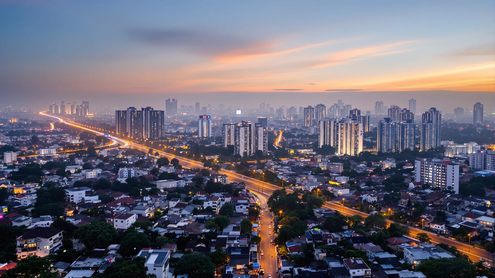
Stand on any terrace in an Indian city and look out. You will see a pattern: rows of three-storey houses each set back the same distance from the road, a wall of apartment towers along the main avenue with squat buildings behind, or a confusing mix of shops under homes and a glassy office dropped among bungalows.
None of this is an accident, and very little of it is purely the result of taste. The shape of your neighbourhood, how tall it is, how far apart the buildings sit, where the shops are, whether you can walk to anything, is to a surprising degree the visible outcome of a rulebook. Planners write abstract numbers, FAR, setbacks, height limits, parking ratios, zoning categories, and those numbers quietly translate into brick, concrete and street life.
This guide helps you read that rulebook in the buildings around you. It is written for the curious citizen, not the planner, so it explains the jargon as it goes and keeps the city examples broad. The exact figures differ from city to city and change over time, so treat everything here as a description of how the levers work, not as a quotable number for your plot.
1. The master plan: deciding what goes where
Before any single building, there is a bigger document. Most Indian cities have a master plan or development plan, a long-term blueprint, often looking twenty years ahead, that maps the whole city and says in broad strokes what each piece of land is for. Delhi has its Master Plan, Mumbai its Development Plan, and most state planning bodies prepare similar documents, with technical support from national bodies like the Town and Country Planning Organisation under the Ministry of Housing and Urban Affairs.
The core tool inside a master plan is land-use zoning. The city is divided into zones, residential, commercial, industrial, public and semi-public, recreational or open space, and each zone carries rules about what you may build there. The intent is straightforward: keep incompatible uses apart. You do not want a chemical factory next to a primary school, or a noisy wholesale market inside a quiet housing colony.
Zoning is the reason a neighbourhood "feels" residential or commercial. When one road is all shops and showrooms while the lane behind it is all homes, you are usually looking at a zoning boundary made physical. Changing a plot from one use to another, what is called change of land use, is a formal, often slow process, which is why zones persist for decades and shape an area long after the original planners are gone.
Zoning is powerful but blunt. Strict separation of uses, taken to an extreme, is also why some Indian suburbs feel lifeless: if homes are kept far from shops, schools and offices, every small errand becomes a drive. Much of modern planning thought, including the ideas in urban design concepts for Indian cities, is a reaction to that blunt separation, arguing for more mixed, walkable zones.

2. FAR and FSI: the dial that sets density
If zoning decides where, the single most powerful rule deciding how much is the Floor Area Ratio, written FAR, or its identical twin the Floor Space Index, FSI. They are the same idea: the ratio between the total floor area you may build and the size of your plot. An FSI of 1.5 on a 1,000 square metre plot means you may build 1,500 square metres of floor space, stacked across however many storeys the other rules allow. We unpack this in FAR vs FSI: development rights.
For the city as a whole, FAR is the density dial. Turn it down and each plot holds only a little floor area, so the same number of people and businesses spread over a larger area. Turn it up and each plot holds more, so the city grows upward instead of outward.
This one number explains a striking contrast across India. Several Indian cities have historically kept FAR remarkably low compared with major cities elsewhere. Low FAR in the core pushes growth to the edges, where land is cheaper and limits looser. The result is sprawl: the city keeps eating farmland at its fringe, commutes lengthen, and infrastructure is stretched thinner over a bigger footprint. Higher FAR lets more people live and work on the same serviced land, producing the vertical look of denser districts.
Neither extreme is automatically good. Very low FAR can mean unaffordable, scarce housing where people most want to live. Very high FAR, without matching investment in water, sewerage, roads and open space, can mean overloaded infrastructure and dark, crowded streets. The interesting question is not "high or low" but "high where, and supported by what."

3. Setbacks and ground coverage: the gaps between buildings
FAR tells you how much floor area in total. Two more rules decide the footprint and the breathing space. Ground coverage is the share of your plot the building may actually sit on, expressed as a percentage. Setbacks are the empty strips you must leave between your walls and the plot boundary, on the front, rear and sides.
Together these produce the most familiar image of the Indian plotted house: a building set in from the road and from its neighbours, with a thin margin of open ground all around. That margin is not wasted space in the eyes of the rulebook. Setbacks let daylight and air reach every home, give fire engines room to approach, leave space for drainage and future road-widening, and stop one person's wall from looming over the neighbour's window.
You can almost reverse-engineer the rules by walking down a street. If every house leaves the same gap from the road, that is a front setback. If two adjacent towers leave a wide gap, that is a side setback scaled up for tall buildings.
These rules trade off against each other. Generous setbacks and low ground coverage give you green, airy, low-density neighbourhoods, but they "spend" land that could have held more homes, which can push up prices. Tight setbacks and high coverage pack more in but risk dark, airless canyons. Every city's residential character is, in part, a particular settlement of that trade-off. The reasoning behind these margins is explored further in why setbacks matter.
4. Height limits and road width: how the street is shaped
Why is one street a tight canyon and another an open boulevard? A big part of the answer is the long-standing planning link between how tall a building may be and how wide the road in front of it is.
The logic is old and sensible. A tall building on a narrow lane casts the whole street into shadow, dumps its traffic onto a road that cannot carry it, and traps fire engines that cannot get close enough. So many Indian bye-laws tie permissible height, or the floor area you can realistically use, to the width of the abutting road. Narrow access roads keep buildings low; wide roads unlock greater height. This is why, in many cities, the tallest buildings line the main arteries while the inner lanes stay low-rise.
This single relationship shapes the streetscape you experience as a pedestrian. It is the reason main roads can feel grand and open while the colonies behind them feel intimate and human-scaled. It also explains a common pattern of growth: when a road is widened, the buildings along it are suddenly allowed to grow taller, and over a few years a low street can transform into a corridor of mid-rises. Some cities deliberately use this, concentrating height along wide roads and metro lines so that density lands where the transport can carry it, an idea known as transit-oriented development.

5. Parking minimums: the rule you can see at street level
Look at the ground floor of almost any modern Indian apartment building and you will often see the same thing: a stilt floor of columns with cars and two-wheelers parked underneath, the homes beginning one level up. That look is largely the product of one rule, the parking minimum.
Most bye-laws require a building to provide a certain amount of off-street parking on its own land, scaled to the number or size of the homes. The intent is to keep private vehicles off public lanes so streets stay clear for movement and emergencies. But the rule shapes the form of the city. Parking is bulky and expensive, so to satisfy the requirement builders raise the homes onto stilts, dig basements, or build podiums, raised decks of parking with housing on top.
Each of those solutions costs money and consumes space, and that cost is folded into the price of your home whether or not you own a car. Aggressive parking minimums also push buildings apart and line streets with blank parking walls or ramps, which is hard on anyone walking. It is one of the clearest cases where a well-meant rule can quietly work against walkability and affordability, a tension explored in why parking rules matter.
6. The missing middle: why we get bungalows or towers, and little in between
Walk through many Indian cities and you notice an odd gap. There are small plotted houses, and there are large apartment towers, but there is relatively little of the comfortable in-between: the three or four-storey walk-up, the row house, the small apartment building of six or eight flats that fits gently into a residential street. Planners elsewhere call this gap the missing middle.
Regulations help produce that gap. When FAR is low and rules favour single plots, you get bungalows. When a builder assembles land and the economics push toward maximising a high FAR, you get towers, with all the lifts, fire systems, podium parking and amenities they require. The medium-density, medium-rise building many people find pleasant to live in falls between the cracks, neither what the small-plot rules encourage nor what tower economics reward.
This matters because the missing middle is often the most human-scaled, affordable and walkable form a city can have. Its absence is one reason so much new Indian housing arrives either as isolated villas or as gated tower clusters, with little of the gentle density that makes a neighbourhood feel alive. What makes that gentler form work is the subject of the anatomy of a good neighbourhood.
7. TDR and premium FSI: trading the right to build
Once you accept that the right to build floor area is valuable and rationed, it follows that cities find ways to buy, sell and grant more of it. Two mechanisms do this, and both are reshaping Indian cities, Mumbai most visibly.
The first is premium or chargeable FSI: beyond a base entitlement, a developer can purchase additional floor area from the authority by paying a premium. The second is Transferable Development Rights, or TDR. When a landowner gives up land for a public purpose, say a strip for road-widening, they may be compensated not in cash but in a certificate granting development rights, the right to build extra floor area, which can be used elsewhere or sold to someone who can. A whole secondary market in these certificates exists.
The effect is that a city's density is no longer a single number on a plot but a stack: base FSI, plus premium FSI bought from the state, plus TDR loaded in from elsewhere, plus incentives near transit. In Mumbai's development control regime this stacking is explicit, and it is a major reason older buildings get redeveloped into much taller ones. These tools let a city raise money and unlock land, but if poorly calibrated they can concentrate intense density onto plots whose roads and drains were never sized for it.
| The rule | What it controls | How it shows up in the city |
|---|---|---|
| Land-use zoning | What may be built where | Streets that feel residential, commercial or industrial; shop-rows beside quiet lanes |
| FAR / FSI | Total floor area per plot | Low FAR spreads the city outward (sprawl); high FAR builds it upward (towers) |
| Ground coverage and setbacks | Footprint and the gaps around it | The set-in plotted house with margins on all sides; spacing between buildings |
| Height vs road width | How tall a building may rise | Tall blocks on wide roads, low-rise on narrow lanes; sunlit versus canyon streets |
| Parking minimums | Off-street vehicle spaces | Stilt floors, basements and podiums; higher home prices; blank parking frontages |
| Premium FSI and TDR | Extra buildable area for sale or transfer | Older buildings redeveloped taller; density stacked onto chosen plots and corridors |
8. What the rules are really trading off
Step back and a single picture emerges. Every one of these rules is a city making a trade-off, usually between two good things it cannot fully have at once.
Light, air and safety pull toward generous setbacks, height limits and low coverage. Affordability and density pull the other way, toward packing more homes onto serviced land near jobs and transit. Order pulls toward strict zoning; flexibility and street life pull toward mixing uses and letting the missing middle fill in. Keeping cars off the road pulls toward parking minimums; walkability and cheaper housing pull against them.
No rulebook wins on every axis. A good set of regulations judges these trade-offs well for a particular place: enough density to be affordable and walkable, enough openness to be livable, enough order to be safe, enough flexibility to be alive. When the judgement is good, you feel it as a neighbourhood that is easy to walk, where daily needs are close and buildings frame pleasant streets. When it is poorly judged, you feel it too, as congestion, long commutes, dead frontages and homes you cannot afford. The same levers, set differently, produce both. Where these rules might head next is the theme of the future of building regulations.

What this means for you
The next time you walk through your own neighbourhood, try reading it as the output of a rulebook rather than as something that simply happened. The matching gap every house leaves from the road is a setback. The towers lining the main avenue while the lanes behind stay low are height tied to road width. The stilt parking under your building, the gap before the next tower, the shop-row that stops abruptly at a zoning line, each is a rule made visible. You will start to see decisions where you used to see only buildings.
Practically, this literacy is useful in three ways. When you buy or build, the zone, the FAR, the setbacks and the parking rule on a plot decide what is actually possible and legal there, so they belong in your due diligence long before you fall in love with a design. When you judge a neighbourhood, you can read its walkability, light and crowding as the result of how its rules were set, not just as luck. And when your city debates a new master plan, a FAR change or a road-widening, you will understand that the abstract argument is really an argument about the city you will live in.
Regulations are not red tape standing between you and your home. They are the instructions, for better and worse, that build the city around it. To explore the rules that apply where you live, see the India Regulatory Atlas.
Sources
- National Institute of Urban Affairs (NIUA), publications on urban land-use planning in India, niua.in
- Ministry of Housing and Urban Affairs (MoHUA) and Town and Country Planning Organisation, master plan and urban development guidance, mohua.gov.in
- NITI Aayog, guidelines on Transferable Development Rights (TDR), niti.gov.in
- Greater Mumbai Development Plan 2034 and Development Control and Promotion Regulations (DCPR) 2034, overview analyses
- Delhi Master Plan (Master Plan for Delhi), Delhi Development Authority
- National Building Code of India 2016 and Model Building Bye-Laws, MoHUA, on setbacks, ground coverage, height and parking
- Institute for Competitiveness, analyses of urban density and FSI in Indian cities
- Academic reviews of FSI as a development-control tool in Indian cities (comparative studies)
Export this guide
Related Guides — Deep-dive reading
FAR vs FSI: Understanding Your Development Rights in India
What Floor Area Ratio and Floor Space Index mean, how they decide how much house you can build, and the traps every Indian homeowner should avoid
Building Regulations & ComplianceWhy Setbacks Matter: A Homeowner's Guide to the Open Space Around Your House
What setbacks are, the daylight, air, fire-access and privacy jobs they do, how they scale with plot and height, and why eating them up costs you your occupancy certificate and resale value
Building Regulations & ComplianceUnderstanding Building Bye-Laws in India: A Homeowner's Guide
What municipal building bye-laws are, who makes them, and how to find and read the ones that actually govern your plot
Building Regulations & ComplianceRelated Tools — Try Free
Cross-Ventilation Analyzer
Estimate airflow and air changes per hour (ACH) from room size, window areas, layout, and local wind — with NBC 2016 Part 8 compliance check.
Ventilation CalculatorApartment vs Villa Interior Planning Guide
Compare ceiling height, structural flexibility, lighting, storage, and services between apartments and villas.
Planning GuideRainwater Tank Sizer
How big should your rainwater tank be? Computes annual harvest, recommended tank capacity in litres, water-bill savings, and payback — for 10 Indian cities.
RWH Calculator