
Utility Planning in Layouts
The invisible infrastructure — water, sewerage and STP, stormwater, power, lighting, telecom and gas; how they share the road section, the water cycle, and why sequencing matters
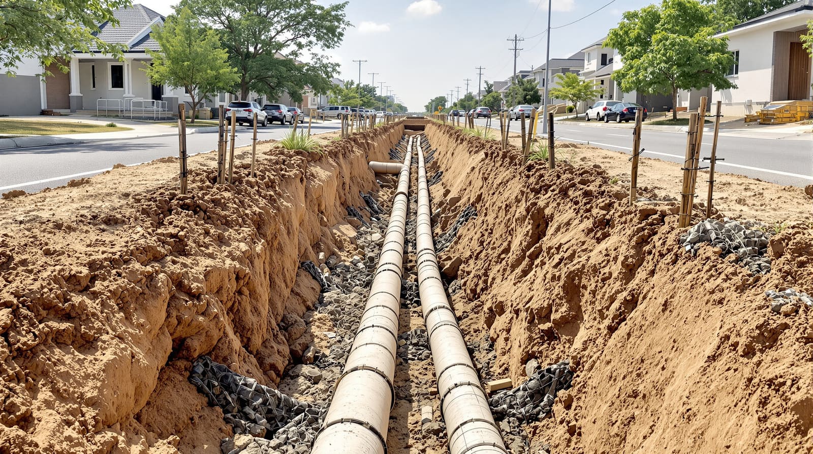
On a humid June morning in a half-built layout on the edge of Hyderabad, you can read the whole future of the neighbourhood in the dirt. Down the centre of the not-yet-tarred road runs a long open trench, and lying beside it in a neat row are the bones of the place: blue HDPE water pipes, fat ringed RCC sewer pipes, a bundle of orange ducts for power and telecom, and a man with a level checking the fall of the line by eye. Plots on either side are still red earth pegged with survey markers. Nobody has poured a foundation yet. In six months there will be houses here, children on bicycles, a small temple at the corner — and not one of these residents will ever see the trench again, or think about it, unless something goes wrong.
That invisibility is the point, and also the danger. In an older, badly-made layout two kilometres away, the story went differently: roads were laid first because they looked like progress, then every plot owner who built a house cut the finished road to bring in a water connection or a drain, and today that street is a quilt of sunken patches, broken edges and a monsoon stream running down the middle because nobody planned where the rainwater should go. A residential layout is not really defined by its plots or even its roads — it is defined by the network of buried and overhead services that move water, waste, power and data through it, and a layout succeeds or fails on whether that network was designed as one coordinated system and laid before the plots, not dug in piecemeal afterwards.
The invisible infrastructure
A plotted layout is a machine for delivering services to land. Strip away the buildings and what remains is a set of overlapping networks, each with its own logic, its own pipe or cable, its own gradient or voltage. Get them to share a corridor gracefully and the layout works for decades; let them fight over the same trench and you get the dug-up street. The systems you have to plan, more or less in order of how unforgiving they are, are these.
Water supply. Every layout needs a source — ideally a municipal or authority main, in practice often borewells plus tanker top-up while the piped network catches up. Water is lifted into storage (an overhead tank or a ground-level sump with a pumped overhead tank) sized to hold roughly a day's demand against pump or supply failure, then distributed through a branching or, better, looped network of pipes that keeps pressure even and avoids dead ends where water stagnates. Demand is reckoned per capita: planners commonly design for something in the order of 135 litres per person per day for piped domestic supply (the figure varies by authority and whether the area is metered), then add fire and gardening allowances and a peak-factor multiplier because everyone bathes at the same morning hour.
Sewerage. This is the system that most distinguishes a properly engineered layout from a glorified field of plots. Foul water from every house has to be collected in a gravity sewer network — pipes that always fall towards a low point — and taken somewhere. In a layout connected to a city trunk sewer, "somewhere" is the municipal system. In the very common case where there is no trunk sewer within reach, a large layout must build and run its own sewage treatment plant (STP), treat the effluent to the standard the pollution control board sets, and reuse or safely dispose of the treated water. Sewage flow is estimated at roughly 80 per cent of water supplied, so the two systems are sized together.
Stormwater drainage. The single most common and most expensive mistake is to assume the sewer can also carry rain. It cannot — and it must not. Stormwater is a separate network, open drains or large-diameter pipes sized for the monsoon's peak intensity, not for daily flow. In an Indian layout the design storm can be brutal and brief, so the drains are far larger than the sewers, and they should not simply rush water off-site: good practice links them to recharge pits, swales and retention so the layout puts water back into the ground rather than flooding the road downstream.
Electricity. Power arrives at high tension (HT) and must be stepped down at a distribution substation or transformer placed inside the layout — which means a small plot has to be reserved for it early. From there a low-tension (LT) network feeds the plots, increasingly run underground in ducts rather than on overhead poles, both for safety and for the cleaner streetscape that a walkable neighbourhood wants.
Street lighting, telecom and data, piped gas, solid waste. The smaller services ride alongside the big three. Street lighting needs its own LT feed and pole foundations along the footpath. Telecom and data want a simple buried duct so fibre can be pulled through later without digging. Piped natural gas, where a city gas distribution company serves the area, needs its own dedicated low-pressure line at a safe separation from electricals. And solid waste, often forgotten, needs designed collection points — a screened bay where door-to-door collection consolidates before it leaves the layout — not a corner that becomes a dump by default.

Everything lives in the road — so coordinate the cross-section
Almost every one of these networks runs along the streets, because the street is the only continuous public corridor that touches every plot. That makes the road cross-section the real drawing that decides whether a layout's utilities will coexist. The carriageway itself — its width, its hierarchy from arterial down to access lane — is its own subject, covered in street hierarchy; here the concern is what is packed into the ground and the verge alongside it.
Below the footpath and the edges of the carriageway, the services are arranged in a deliberate order. Convention puts the water main on one side and the sewer, which needs depth and a steady fall, deeper and usually on the other, with stormwater drains at the kerb line where runoff naturally collects. Electrical and telecom ducts sit shallower, often under the footpath where they are easy to access and safely separated from water and gas. Each service keeps a horizontal and vertical clearance from the others — you never want a leaking sewer above a water pipe, and you never want a power cable sharing a trench with gas. A good utility cross-section reserves a clear lane for every service plus spare capacity, so the layout can be upgraded later without re-trenching.
The reason all this matters is one word: sequencing. The correct order of construction is unglamorous and absolute — set out the roads and plots on the ground, then excavate and lay every underground service, then build the road structure on top, and only then release plots for building. Lay the road first and you guarantee that every later connection cuts it open. This is the buried-services discipline that separates a layout from a subdivision-on-paper, and it is why the borewell-and-tanker layout, where each owner solved water privately, never develops a coherent network at all.


The water cycle of a layout
The most sophisticated way to think about a layout's services is to stop seeing them as separate pipes and see them as a single water cycle. Clean water comes in; rain falls; waste goes out — and a well-designed layout closes the loops between them instead of treating each as a one-way flow to be got rid of.
Supply enters and is stored and distributed. Rain that falls on roofs and roads is harvested and recharged into the ground rather than flushed away, raising the water table that the borewells depend on. Sewage is collected, treated at the layout STP, and the treated effluent is reused for flushing, gardening and construction instead of being dumped. Stormwater is slowed, soaked and only then drained. Done together, these turn a layout from a net consumer that drains its surroundings into something close to water-balanced — which in much of peninsular India, where groundwater is falling year on year, is no longer idealism but survival. This is the territory of water sensitive urban design and blue-green infrastructure, and at the planting-and-pit scale, rainwater harvesting in the landscape; the utility engineer's job is to make the hard network — pipes, drains, recharge structures, the STP — actually deliver that cycle.

What each utility needs, and where it sits
Capacity is the first conversation. Every service is sized from population, which comes from the dwelling-unit count, which comes from density — so utility planning cannot begin until the layout knows how many people it is for. From there the rules of thumb cascade: water demand per capita, sewage at roughly four-fifths of that, stormwater from rainfall intensity and the area of hard surface, electrical load per dwelling plus common areas, all multiplied by peak factors because demand is never flat. Under-size and the layout chokes within a decade; over-size and capital is wasted — so the sizing is honest arithmetic, not guesswork.
| Utility | What it needs | Where it sits |
|---|---|---|
| Water supply | Source, sump & overhead storage (~1 day demand), looped pipe network, pressure | Shallow main along one verge; tank on reserved high plot |
| Sewerage | Gravity network with fall, manholes, the layout STP & reuse line | Deep line on the other verge; STP on a low, downwind corner |
| Stormwater | Separate drains sized for the monsoon peak, recharge structures | Open/large drains at the kerb line, linked to swales & pits |
| Electricity (HT/LT) | Distribution substation/transformer, underground LT ducts | Substation on a small reserved plot; ducts under the footpath |
| Street lighting | LT feed, pole foundations, even spacing | Along footpath verge, clear of canopy trees |
| Telecom & data | Buried duct for later fibre pull, pits at junctions | Shallow duct under footpath, separated from power |
| Piped gas | Dedicated low-pressure line, safe separation | Own trench, clearance from electricals & water |
| Solid waste | Designed, screened collection/segregation points | Bays near entries & common zones, not residual corners |
In India: services are what make the approval real
In Indian practice the gap between a layout that exists on paper and one that functions is, almost entirely, services. The local Town and Country Planning department or development authority — DTCP, BDA, CMDA, HMDA, MCGM and their siblings — approves the layout against the master plan and the Development Control Regulations, and for plotted developments RERA registration applies. But the operative document for a buyer is the layout completion certificate, which the authority issues only once the internal infrastructure — roads, water, sewerage, drainage, electricity, street lighting — is actually built and inspected. A layout that lacks this is the one selling cheap plots where you will later pay for your own borewell, your own septic tank and your own drama every monsoon. The borewell-and-tanker dependence so common on city fringes is precisely the symptom of services that were never networked.
Two India-specific norms recur. First, for large layouts most state pollution control boards and authorities require an on-site sewage treatment plant above a threshold of population or area, with treated-water reuse mandated — so the STP and its small land reservation must be planned from day one, not bolted on. Second, the long-running debate over underground versus overhead power is steadily settling towards underground LT networks in new layouts, for monsoon safety, reliability and the uncluttered streetscape a walkable neighbourhood needs. At the household end these networks meet the home's own systems, the subject of smart infrastructure planning for homes; at the layout end they are the engineering backbone of the whole process set out in the pillar, how to design a residential layout.
References
- URDPFI Guidelines 2014, Ministry of Urban Development, Government of India — norms for water supply, sewerage, drainage and physical infrastructure in urban layouts.
- National Building Code of India (NBC), Bureau of Indian Standards — Part 9 (Plumbing Services) and related parts on water supply, drainage and sanitation.
- Central Public Health and Environmental Engineering Organisation (CPHEEO) Manuals on Water Supply, Sewerage and Stormwater Drainage.
- The relevant State Town and Country Planning Act, Development Control Regulations and layout-approval rules (e.g. Karnataka, Tamil Nadu, Telangana, Maharashtra).
- Central / State Pollution Control Board norms on decentralised sewage treatment plants and treated-water reuse for residential developments.
- Real Estate (Regulation and Development) Act, 2016 (RERA) — registration and disclosure requirements for plotted developments.
Read this alongside street hierarchy explained for the road corridor these services share and water sensitive urban design for the water cycle, and use DesignAI to plan and visualise how your layout's services thread through it.
Export this guide
Related Guides — Deep-dive reading
Rooftop Water Recycling Integration in Homes: One Non-Potable System from Rain and Greywater
How to combine rooftop rainwater harvesting with greywater and STP reuse into a single non-potable water system — the storage, dual plumbing, controls and seasonal logic that make two sources behave like one reliable supply.
Sewage Treatment PlantsComplete Guide to Residential Plumbing in India: Supply, Drainage, Pumps & Storage
The homeowner-and-architect deep dive into a house's plumbing — how water enters, how cold and hot water reach every tap, how waste and rain leave, and how pumps and tanks tie it all together, sized in real Indian numbers.
PlumbingPlumbing Regulations in India: A Plain-English Map of the Rules
The Regulations pillar for the Studio Matrx Plumbing Knowledge Hub — how NBC 2016 Part 9, BIS/IS standards, CPHEEO manuals, state PHED norms, local municipal bye-laws, rainwater-harvesting mandates, groundwater permissions and building-plan approvals fit together, who issues what, and why the binding rules are almost always your local bye-laws.
PlumbingRelated Tools — Try Free
Rainwater Tank Sizer
How big should your rainwater tank be? Computes annual harvest, recommended tank capacity in litres, water-bill savings, and payback — for 10 Indian cities.
RWH CalculatorGarden Planning Toolkit
Get a tailored garden plan — planting layers, Indian species, features and a checklist — from your climate, space, sun and goals.
PlannerCross-Ventilation Analyzer
Estimate airflow and air changes per hour (ACH) from room size, window areas, layout, and local wind — with NBC 2016 Part 8 compliance check.
Ventilation Calculator