
Water-Sensitive Rural Planning
Planning a village to work with its water — reviving tanks, johads and percolation ponds, reading the watershed, harvesting rain at every scale, and surviving drought and the monsoon
In the dry month of May, the old tank at the edge of the village is a cracked saucer of grey clay, its stone steps marching down to a puddle the buffaloes have churned into soup. The borewell near the temple gave out last year at three hundred feet; the panchayat sank a new one at six hundred, and already the women say the water tastes of iron. Then in July the sky breaks, and for three furious weeks the rain comes sideways. The lane below the school becomes a brown river, the lowest houses take water to the knee, and within a month — once the clouds have gone — the village is thirsty again. All that rain ran away in a fortnight, taking the topsoil with it.
A generation ago this same village knew exactly what to do with that rain. The tank caught the runoff from the hill above; small earthen johads held water in the fields so it could soak down; the open wells filled quietly through the year because the tank kept the ground beneath them wet. The knowledge did not vanish because it was wrong. It vanished because piped schemes, free electricity for pumps and the easy borewell made it feel unnecessary — until the water table fell out from under everyone. A water-wise village is not built by importing a city's drainage; it is planned to work with its own watershed — catching every drop where it falls, storing it in the tank and the soil, recharging the wells, reusing the greywater, and letting the violent monsoon pass through without drowning the settlement.
Water is the first layout decision, not the last
In a city, water-sensitive design is retrofitted into an already-paved grid — sunken parks, permeable pavers, engineered swales. The urban approach, set out in water sensitive urban design and the wider blue-green infrastructure playbook, is centralised, engineered and bolted onto hard surfaces after the fact. The rural version is the opposite in spirit: decentralised, traditional and watershed-led. A village still has soft ground, a visible slope, a living tank and a community that meets. It can do the thing a city can rarely afford — plan the settlement around how water actually moves across the land.
That means the very first map a planner draws for a village is not the road network or the housing plots. It is the water map. Where does the rain fall, where does it gather, where does it leave, and where does it sink? Get that right and the rest of the rural housing layout design follows naturally — the settlement sits on the safe high ground, the tank and commons sit at the natural collecting point, the fields take the overflow. Get it wrong and no amount of pipes will fix a village that has been planted in the path of its own runoff.

The traditional genius — and why it still works
India did not learn water harvesting from a manual; it built civilisations on it. The vocabulary changes with the region but the logic is one. The Tamil eri system chained thousands of tanks down a watershed, each one's overflow feeding the next. In the Deccan a tank is a kere; in the north and west the village pond is a talab or johad, and Rajasthan's johad revival — earthen check dams across small catchments — is one of the best-documented water recoveries anywhere. Gujarat and Rajasthan dug step-wells (baoli, vav) that reached groundwater as architecture. Everywhere there were percolation ponds whose purpose was never to hold water for long but to let it soak down and refill the wells.
These were not pretty heritage. They were a distributed, gravity-fed, community-managed water system that needed no electricity and no outside agency — only the discipline to de-silt the tank each summer and to protect its catchment. When that discipline lapsed, the structures silted up, were encroached, or were simply forgotten once the borewell promised water on demand. Reviving them is not nostalgia; it is the cheapest, most climate-robust infrastructure a village can own.

Read the watershed before you draw a road
Water does not respect revenue boundaries; it obeys contours. The discipline that ties all of this together is watershed thinking — treating the whole catchment from ridge to valley as one hydrological unit, even when it crosses several villages. Walk the land after a heavy shower and the water tells you everything: the ridgelines that shed it, the natural drainage lines (the nullahs) that carry it, the flat low point where it pools, and the porous soils where it sinks fastest.
From that reading, every intervention finds its right place. Up on the slopes, contour bunds and trenches slow the sheet-flow and let it soak rather than scour. Across the small streams, a sequence of check dams and gabions holds water in steps so it percolates instead of racing away with the topsoil. At the natural collecting point, the village tank or percolation pond. On the safe higher ground above the flood line, the houses. This ridge-to-valley sequence — treat the ridge first, the valley last — is the core of every successful Indian watershed programme, and it is exactly what a green-field village layout should encode from day one. The same instinct that places homes safely above water also shapes the community open spaces in villages — the tank and its steps are the commons precisely because they sit where the water wants to be.

Harvest at every scale
Rainwater harvesting in a village is not one structure; it is a nested set, each catching what the scale above lets through. At the rooftop scale, even a modest tiled or RCC roof can fill a household tank or a recharge pit for a few months of the year — and a recharge pit that puts the roof water back into the ground is often worth more than a storage tank, because it lifts the whole village's water table, not just one home. The principles carry over almost unchanged from rainwater harvesting in the landscape, only multiplied across every house and the commons.
At the farm scale, field bunds and farm ponds keep the monsoon on the land long enough to grow a second crop and recharge below. At the community scale come the percolation ponds, recharge wells and the tank itself. The point is not to pick one — it is to layer them so that water is slowed, used and sunk again and again on its way down the watershed.
| Water move | Scale | Benefit |
|---|---|---|
| Rooftop harvesting & recharge pits | Household | Drinking water store; lifts the local water table |
| Contour bunds & trenches | Slope / catchment | Slows sheet-flow, stops soil loss, aids percolation |
| Check dams & gabions | Stream / nullah | Holds monsoon water in steps, recharges downstream wells |
| Farm bunds & farm ponds | Field | Soil moisture, a second crop, on-farm recharge |
| Percolation ponds & recharge wells | Community | Refills the borewells & open wells village-wide |
| De-silted village tank | Settlement / commons | Year-round store, livestock & ritual use, the heart of the gram |
| Greywater reuse (soak pits, DEWATS) | Household / cluster | Turns wastewater into garden water; protects the tank |
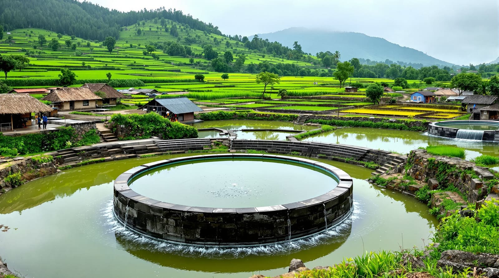
Revive the tank, manage the borewell crisis
The single highest-return project in most villages is to revive the old tank. De-silt it — the excavated silt is rich field soil the farmers will gladly cart away — repair its bund and the sluice (the waste weir that lets surplus pass safely), clear the feeder channel that brings runoff in, and above all protect and re-vegetate its catchment so the water arriving is clean and the tank is not silted again within a few seasons. A living tank is a battery that recharges every well around it; that is why the wells used to stay sweet.
It also reframes the borewell. The falling water table is not, at root, a drilling problem — it is a recharge problem. A village that pumps groundwater faster than the monsoon puts it back will chase the water deeper and deeper until the bore yields salt, fluoride or nothing. The cure is to put water back: recharge wells fed by rooftops and ponds, check dams across the streams, and a hard community decision to cap how many new bores are sunk. You cannot drill your way out of a deficit you can only recharge your way out of.
Reuse the greywater, and let the monsoon pass through
The water a village uses for bathing, washing and the kitchen — the greywater — is a resource, not a nuisance, and managing it close to source keeps the tank and ponds clean. At the household scale, a simple soak pit or a kitchen garden fed by bath and kitchen water turns daily wastewater into vegetables and recharge. At the cluster scale, a DEWATS unit (Decentralised Wastewater Treatment System — settler, anaerobic baffled reactor and a planted gravel filter, all gravity-fed and electricity-free) cleans the combined greywater of a hamlet to a quality fit for irrigation. This pairs naturally with the twin-pit toilets of Swachh Bharat — Gramin and keeps faecal waste entirely out of the water cycle.

The same monsoon that must be harvested must also be allowed to pass through the settlement without drowning it. This is where layout and water meet. Houses sit on raised plinths above the recorded flood mark; the settlement avoids the natural low point, which is left to the tank, the pond or a green to flood harmlessly; and an open, gently-graded drainage network — earthen swales lined with grass rather than choked concrete drains — carries the surge to the tank and the fields, not into the lanes. A drought-prone village and a flood-prone village need the same map read in two directions: one stores every drop, the other speeds the surplus safely away, and most Indian villages now need both in the same year.
Make it real — the gram sabha, the schemes, the commons
None of this holds without the institution that owns the water. Under the 73rd Amendment the gram sabha — the assembly of every adult voter — is the body that can protect the tank, its catchment and the feeder channels as a commons against encroachment and over-extraction. Tanks die when they become nobody's responsibility; they live when the gram sabha sets and enforces the rules — who may pump, who de-silts, what the catchment may be used for.
The money and the labour already exist in the schemes. MGNREGA is, in practice, India's largest water-works programme: a vast share of its person-days has gone into exactly these assets — farm ponds, check dams, contour trenches, tank de-silting. Watershed funding and the Rurban (SPMRM) cluster approach can pay for the larger structures. And Jal Jeevan Mission — the drive for a tap in every rural home — raises the hardest question of all: a tap is only as reliable as its source. Piped water that draws on an unrecharged borewell simply moves the crisis indoors. The mission succeeds in a village only where the source itself — the tank, the wells, the recharge — has been made sustainable first. That source-protection logic is part of the wider rural infrastructure planning a village must get right, and it is the quiet thread running through every climate-resilient settlement, as set out in climate-responsive rural settlements. The tank-revival movements of recent decades — in Rajasthan, Tamil Nadu, Maharashtra and beyond — all share one finding: the engineering is the easy part; the gram sabha owning the water is what makes it last.
References
1. Ministry of Rural Development, Government of India — MGNREGA Operational Guidelines and Natural Resource Management / watershed works provisions.
2. Ministry of Jal Shakti — Jal Jeevan Mission Operational Guidelines and the Master Plan for Artificial Recharge to Groundwater (Central Ground Water Board).
3. The Constitution (Seventy-third Amendment) Act, 1992 — provisions on the gram sabha and panchayat functions, including minor water bodies and watershed development.
4. CPHEEO, Ministry of Housing & Urban Affairs — Manuals on Water Supply and on Sewerage & Sanitation (rural decentralised treatment, DEWATS principles).
5. URDPFI Guidelines 2014, Ministry of Urban Development — settlement planning, rural area planning and water-resource provisions.
6. M. K. Gandhi, Hind Swaraj / Village Swaraj — the case for the self-reliant, resource-managing village community.
7. Anupam Mishra, Aaj Bhi Khare Hain Talab (The Ponds Are Still Relevant) — traditional Indian water-harvesting structures and their community management.
Plan the settlement that this water serves with the rural housing layout design pillar, gather the village around its revived tank through community open spaces in villages, and turn your own watershed reading into a layout with DesignAI.
Export this guide
Related Guides — Deep-dive reading
Rainwater Harvesting Through Landscape Design — Slow It, Spread It, Sink It
The soft, landscape-led side of harvesting rain — contouring, swales, permeable surfaces and recharge structures that catch water where it falls
LandscapePercolation Tanks & Ponds in India: Recharging Groundwater at Plot, Farm and Watershed Scale
A professional guide to percolation tanks — impounding monsoon runoff in a shallow surface basin so it slowly infiltrates and recharges the aquifer. How they work, where they suit, siting, indicative sizing, silt management and how they relate to check dams.
PlumbingThe Sponge City: How Kongjian Yu Taught China's Cities to Drink the Rain
Landscape architect Kongjian Yu and his firm Turenscape reframed the flood-prone city as a living sponge — a national programme, launched in 2013–14 across dozens of Chinese cities, that swaps concrete pipes for wetlands, rain gardens and terraces. A study of its ecological logic, its flagship parks, and the hard question of what a sponge can and cannot hold.
The Future of ArchitectureRelated Tools — Try Free
Rainwater Tank Sizer
How big should your rainwater tank be? Computes annual harvest, recommended tank capacity in litres, water-bill savings, and payback — for 10 Indian cities.
RWH CalculatorCross-Ventilation Analyzer
Estimate airflow and air changes per hour (ACH) from room size, window areas, layout, and local wind — with NBC 2016 Part 8 compliance check.
Ventilation CalculatorGarden Planning Toolkit
Get a tailored garden plan — planting layers, Indian species, features and a checklist — from your climate, space, sun and goals.
Planner