
Climate-Responsive Rural Settlements
Planning the whole settlement for its climate — clustering, orientation and spacing for shade and breeze, the tank and canopy as cooling, and resilience to flood, drought, heat and cyclone
By the second week of May, the heat in the village had become a kind of weather you could see. It hung over the open fields in a white shimmer, and by noon the new lanes — laid out straight and wide in the recent layout, their plinths in concrete block, their roofs in flat RCC — were empty. Where the old hamlet still stood, though, the streets were narrow and crooked, the houses leaned shoulder to shoulder, and a peepal threw a pool of shade over the chabutara where the old men sat through the worst of the afternoon. A breeze that had crossed the tank came up the eastern lane, lost some of its heat over the water, and slid between the close-set walls. Two settlements, the same sun, two entirely different afternoons.
That contrast is the whole subject of this guide. The old hamlet was not designed by an architect; it was settled, over generations, by people who could not afford to get the climate wrong, and so its form — where it sat in the land, how tightly it clustered, which way its lanes ran, where it kept its water and its trees — quietly encoded the local climate. The new layout was designed by a draughtsman in a town who had never spent a May afternoon in it. A rural settlement keeps its people cool, dry and safe at the scale of the whole village — through its clustering, its lane orientation, its tank and its tree canopy — long before any single house is built; plan the settlement for its climate first, and the houses have far less work to do.
Climate is a settlement decision, not just a building one
There is a good and growing body of work on climate-responsive houses — thick walls in the hot-dry west, raised stilts and deep verandahs in the humid south, tight south-facing rooms in the cold hills. That knowledge belongs at the building scale, and our companion piece on Indian vernacular architecture and the climate-responsive landscape design guide handle the house and the planting in detail. This guide deliberately works one scale up. It is about the gram — the village of fifty to five hundred households — as a single climatic object.
The reason the scale matters is that the most powerful climate tools a village has are shared, not private. One house cannot make a breeze; a cluster of houses, set the right distance apart and aligned to the prevailing wind, can pull air through the whole settlement. One household's tree gives one household shade; the village tank and the canopy of an avenue of trees can lower the air temperature across the entire built area. A single raised plinth saves one family in a flood; a settlement set off the low point of the land, with its lanes doubling as escape routes, saves everyone. The commons — the tank, the grove, the square, the cattle ground — are not leftover space. At the village scale, the commons are climate infrastructure.
This is also where the contrast with the urban cousins in this cluster is sharpest. The principles in how to design a residential layout in India assume serviced plots, sealed surfaces and mechanical cooling as a fallback. A village has none of those luxuries and does not want them: it has wind, water, earth and shade, and a community that manages them collectively. Climate response in a village is therefore less an engineering specification and more a settlement design — and a survival strategy as the climate grows more violent.
Settlement-scale passive design — cluster, orient, space
The three settlement-scale moves are how tightly you cluster, which way you orient the lanes and homesteads, and how far apart you set things. Each is read differently by each climate.

In the hot-dry zone — much of Rajasthan, Gujarat, the interior Deccan — the enemy is the sun and the daytime heat, and the friend is the cool night and the thick wall that stores it. The right settlement form is compact and self-shading: narrow, often winding lanes so that walls shade walls and the ground rarely sees direct noon sun, homes packed close around small shared courtyards, and built mass dense enough to hold the night's coolness into the day. The old desert towns of Jaisalmer and the dense gram clusters of arid Kutch do exactly this. Wide, straight, sun-baked roads are the worst possible move here.
In the warm-humid zone — coastal Kerala, coastal Andhra and Odisha, the lower Ganga and Brahmaputra plains — the enemy is not heat alone but heat plus moisture, and the only relief is moving air. Here the settlement should be the opposite: loose and spaced, with homesteads set apart so wind can pass between them, lanes run open along the prevailing breeze, plinths raised off damp ground, and built mass kept light and cross-ventilated. Dense clustering would trap stale, humid air — exactly what you must avoid. The traditional scattered homesteads of Kerala and the linear, breeze-aligned riverbank villages of Assam read this correctly.
In the cold and hill zones — the Himalayan belt, the high Deccan in winter — the village must catch the sun and shelter from the wind. Compact clusters again, but now to share warmth and cut wind exposure; homes turned to the south or south-east to take the low winter sun; settlements tucked onto the sheltered, sunny slope rather than the cold, shaded one or the exposed ridge. The stepped, sun-facing villages of Himachal and Ladakh are textbook.
The composite zone — most of the north Indian plain, which is hot-dry for part of the year and warm-humid in the monsoon — needs a compromise: moderately compact, with lanes that admit the summer evening breeze but offer shaded, sheltered courts for the dry heat and the cold spell. Orientation here earns its keep: a lane that runs roughly along the prevailing wind moves air in the humid months, while east-west homestead frontages keep the harsh low east and west sun off the main walls. The detailed mechanics of running and spacing those lanes sit in the village street planning guide; what matters here is that the street grid is a climate instrument before it is a traffic one.
The tank and the canopy — the commons as a cooling system
If clustering and orientation are the village's passive structure, the tank and the tree canopy are its active cooling plant, and they cost nothing to run.

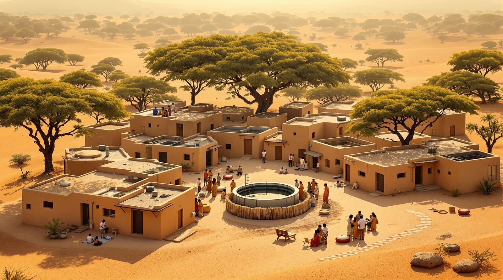
The village tank — the talab, johad, kere or pukur, with its steps down to the water — is the oldest piece of climate infrastructure in rural India, and it does several jobs at once. It recharges the groundwater the wells depend on; it stores the monsoon for the dry months; and, placed upwind of the settlement, it cools the breeze by evaporation before that air ever reaches a house. A village that filled its tank with a layout of plots threw away its air-conditioner. The water-management side of the tank — recharge, drought storage, the falling water table — is the proper subject of the water-sensitive rural planning guide; here the point is purely climatic: keep the tank, keep it upwind, and let the prevailing wind run from it into the village.
The tree canopy is the second free cooling system, and it works at the settlement scale only if it is planted at the settlement scale — as avenues along the main lanes, a dense grove or sacred orchard at the edge, and shade trees over every shared node: the square, the bus stop, the threshing floor, the cattle ground. A mature canopy shades the ground before it can heat, transpires moisture, and can hold the air beneath it several degrees cooler than open sun. Species matter — deep-rooted, deciduous natives such as neem, peepal, banyan, tamarind and mango that shade in summer and (where deciduous) let the winter sun through; our best trees for Indian homes guide covers the choices. At the village scale the planting is also a job: the avenues, groves and tank embankments are exactly the kind of asset a community can create under MGNREGA, turning shade into wage work.
Read together, tank and canopy form a cooling loop — water upwind, breeze across it, canopy over the lanes it travels — that a single building can never reproduce. This is the deepest reason climate response must be planned for the whole settlement.
Climate resilience — designing the village to survive the disaster
Cooling is the everyday climate problem. The other, sharper problem is the extreme event — and these are growing more frequent and more violent across India: hotter and longer heatwaves, more erratic and intense monsoons, more frequent cyclones on both coasts, and recurrent flood and drought. A climate-responsive village is one that survives its worst day, and that survival is designed into the settlement form.

Flood-prone settlements — the river plains of Assam, Bihar and eastern Uttar Pradesh, deltaic Odisha and West Bengal. The first rule is the cheapest: do not settle the low point. Keep the built cluster on the higher ground, raise plinths well above the known flood line, and where the whole terrain is low, build a mandh or raised earthen mound — the traditional flood refuge of the Brahmaputra and Kosi villages — large enough to take homes, livestock and grain. Lanes must double as clear, high escape routes leading out and up to a marked safe point, and a protective embankment or bund can hold back the ordinary flood while a deliberate low spillway lets the extreme one pass without bursting through the houses.
Drought-prone settlements — the rain-shadow Deccan, interior Rajasthan, Marathwada and Bundelkhand. Here resilience is water-first planning: the settlement is organised around securing and recharging water before anything else — the tank, the percolation pond, the check dam and the recharge of every well — so the village does not empty out in a bad year. Because this overlaps so heavily with water, the detailed playbook is in the water-sensitive rural planning guide; the settlement-design point is simply that the layout must put the water assets in the right place in the catchment and protect their catchment from being built over.
Cyclone and coastal settlements — the Bay of Bengal coast of Odisha, Andhra and Tamil Nadu, and the Saurashtra and Konkan coasts. The settlement needs a community cyclone shelter on high ground within walking reach of every home; built clusters set back from the surge line and tucked in the lee of natural protection; and, crucially, the mangrove belt or coastal shelterbelt kept intact as a buffer that breaks the wind and the wave. The Odisha super-cyclone of 1999 taught the lesson in the hardest way, and the shelter-plus-mangrove model that followed has saved many lives since. A village that clears its mangroves for plots removes its own seawall.
Heat-vulnerable settlements are addressed by everything above — shade, water and canopy — but resilience adds the social layer: a shaded, cool community space (often the school or the chaupal) that can serve as a heat refuge, and tree cover and water deliberately placed where the most exposed work and walk.
Landslide and hill settlements must respect the slope: build on the stable, gentle ground and off the steep cut or the debris path, follow the contour rather than cutting brutally across it, and manage the run-off so the monsoon does not undercut the hillside the village sits on.
Across all of these, climate is also beginning to move people. Failing monsoons, salt-poisoned coastal fields and repeated floods are quietly driving climate migration — sometimes emptying villages, sometimes swelling a safer neighbour. A resilient settlement plan thinks about this too: keeping a margin of safe, serviced land for families relocating off a vanishing floodplain or eroding coast, rather than pretending the map is fixed.
A table — climate zone to settlement response
| Climate zone | Where (broadly) | Settlement form | Tank & canopy move | Chief climate risk & resilience response |
|---|---|---|---|---|
| Hot-dry | Rajasthan, Gujarat, interior Deccan | Compact, self-shading clusters; narrow winding lanes; heavy mass | Tank upwind for evaporative cooling; dense shade groves & avenues | Extreme heat & drought — shade, water-first planning, heat refuge |
| Warm-humid | Coastal Kerala, Andhra, Odisha; lower Ganga & Brahmaputra | Spaced, raised, cross-ventilated; lanes along the breeze | Tank for recharge; open canopy that shades but does not block wind | Flood & cyclone — raised plinths/mounds, shelter, mangrove buffer |
| Composite | North Indian plain | Moderately compact; breeze-aligned lanes, shaded courts | Tank upwind; lane avenues for shade | Heat, monsoon flooding & cold spell — flexible shade plus drainage |
| Cold & hill | Himalayan belt, high Deccan | Compact sun-catching clusters on the sheltered sunny slope | Less critical; windbreak planting; sun-facing open space | Cold, wind & landslide — sheltered siting, slope & run-off control |
| Coastal | Bay of Bengal & Arabian Sea coasts | Clusters set back & in the lee; community shelter within reach | Tank for freshwater; intact mangrove/shelterbelt as buffer | Cyclone, surge & erosion — shelter, set-back, mangrove, escape routes |
Making it real — the panchayat, the schemes and the commons
None of this is delivered by a master plan handed down from a district office; in rural India it is delivered, or lost, at the level of the gram panchayat and the gram sabha, the bodies empowered by the 73rd Constitutional Amendment to plan and manage the village commons. The climate-responsive moves in this guide are, almost all of them, decisions about common land — where the tank sits, whether the grove and the mangrove are protected, which way the main lane runs, where the safe high ground and the escape route are kept clear. That makes the gram sabha resolution, not the drawing, the real instrument of climate response.
The schemes can fund the work if the village asks for the right things. The avenues, the tank desilting, the percolation ponds, the check dams and the flood mound are natural MGNREGA assets — climate infrastructure built as wage work. Housing under PMAY-G (Pradhan Mantri Awaas Yojana – Gramin) can be sited and oriented well, on raised plinths in flood country, if the panchayat insists on it rather than letting a contractor drop identical concrete boxes on the cheapest land. Where a cluster of villages is being developed together under SPMRM (the Rurban Mission), the shared shelter, the protected commons and the canopy can be planned across the whole cluster — the spirit of the cluster village development approach. And the SVAMITVA survey of abadi (lal-dora) land, by finally mapping the village clearly, gives the panchayat the very base map it needs to protect the low point, the catchment and the grove from being quietly built over.
The honest warning is the one the opening scene gives: the default trajectory is against all of this. The concrete-box rollout — flat RCC roofs, straight wide roads, plots laid over the tank-bed, the grove felled, the mangrove cleared — is spreading fast and is climatically illiterate almost everywhere it lands. The traditional settlement got the climate right by necessity and is being discarded just as the climate turns more dangerous. The work, set out across this cluster and anchored in the rural housing layout design pillar, is to carry that inherited intelligence forward deliberately — to plan the whole settlement for its climate, on purpose, before the bulldozer decides for us.
References
1. Ministry of Rural Development, Government of India — Pradhan Mantri Awaas Yojana – Gramin (PMAY-G) operational guidelines.
2. Ministry of Rural Development, Government of India — Shyama Prasad Mukherji Rurban Mission (SPMRM) framework for implementation.
3. The Constitution (Seventy-third Amendment) Act, 1992 — powers of the gram panchayat and gram sabha over village land and the commons.
4. Ministry of Urban Development — URDPFI (Urban and Regional Development Plans Formulation and Implementation) Guidelines, 2014, Volume I (climate and settlement planning norms applied at the rural scale).
5. National Building Code of India (Bureau of Indian Standards) — provisions on climate-responsive design and natural hazard zoning (flood, cyclone, seismic).
6. CPHEEO, Ministry of Housing and Urban Affairs — manuals on rural water supply, recharge and the village tank.
7. M. K. Gandhi, "Hind Swaraj" and the writings on village swaraj — the self-reliant, self-governing village as a planning ideal.
Read this alongside its sibling guides on water-sensitive rural planning and modern village planning principles, and when you are ready to test a settlement layout against its climate, bring it to DesignAI.

Export this guide
Related Guides — Deep-dive reading
Cluster Village Development
Grouping homesteads and whole villages to share what scattered settlements cannot afford — compact clustering vs dispersal, the SPMRM Rurban model, and the economics of shared rural infrastructure
Rural Residential PlanningCommunity Open Spaces in Villages
The commons that are a village's true structure — the tank and its steps, the chaupal, grazing ground, threshing floor, sacred grove and tree-plinth — how they are shared, lost to encroachment, and revived
Rural Residential PlanningClimate-Responsive Landscape Design for India
Designing your garden to work with India's five climate zones — shade, water, air and planting palettes that fit hot-dry, humid, composite and cold
LandscapeRelated Tools — Try Free
Cross-Ventilation Analyzer
Estimate airflow and air changes per hour (ACH) from room size, window areas, layout, and local wind — with NBC 2016 Part 8 compliance check.
Ventilation CalculatorWindow Orientation Planner
Pick the best window type, glass and shading by wall direction — north, east, south and west.
Window ToolInterior Layout Planner — Printable Graph Grid
Printable graph grid to sketch room layouts to scale before committing to furniture placement.
Layout Tool