
Village Street Planning
Planning village lanes as social space, not traffic channels — the cart-and-foot hierarchy, sections sized for bullock carts and tractors, gathering nodes, and honest paving and monsoon drainage
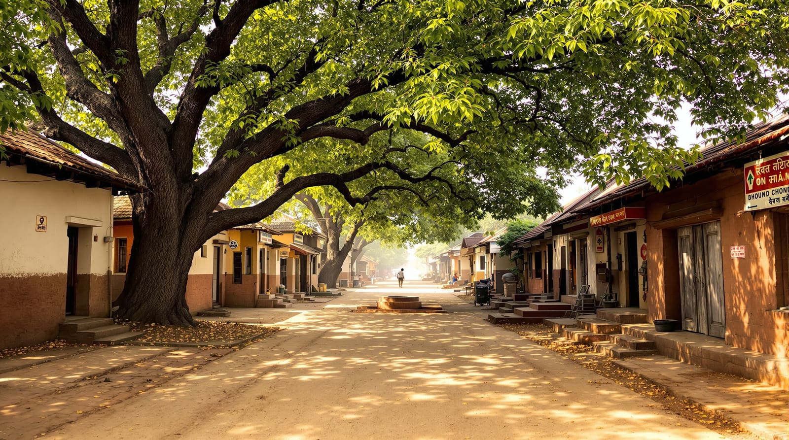
In a village in interior Maharashtra, the lane outside Shantabai's house is doing six things at once. A pair of bullocks ambles down its earthen centre, driven by a boy who barely needs to steer them — they know the way to the threshing floor. Two girls draw hopscotch squares in the dust against the wall. An old man dozes on the raised stone plinth that runs along the house front, the otla that doubles as bench, drying-platform and front porch. A woman fills a brass pot at the handpump where the lane bends. A motorcycle threads past all of it, slowing without anyone asking it to. And by mid-morning the lane will absorb a tractor returning from the fields, its trailer brushing the neem branches overhead.
None of this was designed by a traffic engineer, and that is precisely the point. The lane is not a pipe for moving vehicles from A to B; it is the most-used room of the village, walled by house fronts, roofed in places by trees, and shared by every age, species and errand in the settlement. When a new layout or a road-upgrade scheme treats it as merely a carriageway — straightening it, widening it for cars, sealing it kerb-to-kerb in tar — the village loses something it cannot rebuild. A village street is social space first and a movement channel second; plan its width, surface and meeting-points for feet, carts and cattle, and the traffic will look after itself.
Why the village street is a different problem
Urban road planning begins with vehicles and works backward: estimate traffic volume, classify the road, fix a cross-section, then fit footpaths in whatever margin remains. That logic is laid out in our guide to urban street hierarchy, where arterials feed collectors feed local roads in a tree of falling car capacity. It is a sound logic — for a town where the car is the dominant user and the street's job really is to move it.
A village inverts every assumption. The dominant users are pedestrians, livestock and slow farm vehicles, with the occasional car or bus as the exception. Peak "traffic" might be a wedding procession, a funeral, a herd returning at dusk or a tractor at harvest. The street is also where grain is dried, where the panchayat argument spills out of the chaupal, where the bride's family is received. So we do not borrow the urban arterial-to-collector cross-sections at all. We size lanes by the turning circle of a bullock cart and the width of a tractor-trailer, we keep most surfaces walkable and permeable, and we widen the street where people naturally gather rather than where cars queue. This guide sits under the rural housing layout design pillar and works alongside the principles in modern village planning.
The real hierarchy at village scale
A village does have a street hierarchy — but it is graded by user and intimacy, not by traffic count. Five levels recur across Indian settlements, and a good layout makes each legible so a stranger, a tractor and a child all know where they belong.

The approach road and bus edge. This is the one genuinely vehicular element — the all-weather link from the district road to the village, usually a Pradhan Mantri Gram Sadak Yojana (PMGSY) road, ending at the bus stop, the shop cluster and perhaps the dairy collection point. It is the village's front door and its only piece that should be designed to carry a bus, an ambulance and a fire tender. Crucially, it should arrive at the edge of the settlement and stop, or skirt it — not drive a hard tarred spine straight through the residential core.
The main village street. The settlement's spine, running from the entry node past the temple or mosque to the commons. It carries carts, tractors, the odd jeep and the daily pulse of people. It needs to let a tractor-trailer and a cart pass each other, and to reach the chaupal and the tank.
The residential lane. The everyday street of the housing clusters — foot and cart, the cattle going out at dawn and back at dusk, children, the water-pot walk. Through-vehicles have no business here.
The gali. The narrow footpath-width passage between house plots — sometimes barely a metre and a half — for pedestrians, a single cow, a cycle. It knits clusters together and gives shaded shortcuts.
The cattle track. The unsung route from the gauthan (the cattle ground) and the homes to the grazing land and fields, kept earthen and often hedged, deliberately separate from the social lanes so dung, hooves and herds do not foul the gathering spaces.
Widths driven by the cart, the tractor and the fire tender
Forget car volumes; size the street by the largest thing that genuinely uses it and the access the village must guarantee in an emergency. A bullock cart is roughly 1.5 to 1.8 m wide; a tractor with a trailer can be 1.8 to 2.2 m and needs a generous turning swing; a fire tender or ambulance needs a clear, firm path to every cluster. So the main street must let two carts or a cart and a tractor pass — but the residential lane only needs one cart plus a walking margin, and the gali needs none of it.
This is also where honesty about reach matters. National Building Code provisions and good practice ask that no dwelling be unreachable by a fire or ambulance vehicle, which in a dense organic core means planning at least a few firm-surfaced loops or stubs that a tender can enter and turn in — not sealing every gali. Plan emergency reach as a network property, not by widening every lane.

The cross-section of a residential lane is the heart of the matter. At its centre runs the cart-and-foot way — firm enough for a loaded cart in monsoon, but not necessarily tarred. Along one or both edges sits the otla, the raised house plinth that serves as bench, workspace and the threshold between private and public. A shade tree or two punctuate the edge. And running along the lower side is the drain — the single most important and most neglected line in the whole section, because in the monsoon the lane either sheds water or becomes a river of mud.
A village street typology
| Street type | Indicative width & primary users | Surface & character |
|---|---|---|
| Approach road / bus edge | ~5–7 m carriageway; bus, ambulance, fire tender, occasional truck | All-weather (PMGSY) sealed or gravel; stops at the village edge, not through the core |
| Main village street | ~4.5–6 m; tractor & trailer, cart, jeep, foot, daily crowd | Firm, partly paved spine; widens at the temple, well & chaupal |
| Residential lane | ~3–4.5 m; foot, cart, cattle at dawn & dusk, cycle, motorcycle | Earthen or stabilised; plinth (otla) edges, shade trees, side drain |
| Gali / footpath | ~1.5–2.5 m; pedestrians, single cow, cycle | Permeable, shaded; pure pedestrian shortcut, no through-vehicle |
| Cattle track | ~3–4 m; herds, dung-cart, farm movement | Earthen, often hedged; deliberately routed away from social lanes |
Treat these as starting bands to argue from in the gram sabha, not fixed standards — the right width is the one the village's own carts, herds and emergency access actually demand.
Nodes — where the street becomes a square
In a village the most important parts of the street network are not the lanes but the places where they meet and widen. These are the rooms of the settlement: the chaupal or chabutara (the raised village platform where the panchayat and the elders gather), the well or handpump where the morning queue becomes a conversation, the temple or mosque steps, the great tree, the dairy collection point. A well-planned village does not scatter these — it lets the street swell at each meeting-point into a shaded, paved-enough social space, and threads the lanes so they arrive at these nodes rather than bypass them.

This is the seam where street planning hands over to the planning of the commons themselves, which we treat in community open spaces in villages. The discipline for the street designer is simple: identify the four or five natural gathering points, make the lanes converge on them, give them shade and a hard-enough surface to sit and dry grain on, and resist the urge to drive vehicles through their middle.
Paving honestly — and the monsoon mud problem
The single biggest temptation in a "developed" village is to tar everything. Resist it. Comprehensive sealing bakes the lanes in summer heat, sends every drop of monsoon runoff racing to the lowest house instead of percolating, and lowers an already-falling water table. The honest approach is graded: pave for all-weather access only where it is truly needed, and keep permeable earth or stabilised surfaces everywhere else.

A workable rule of thumb: harden the approach road, the main spine and the emergency loops; use permeable paving, brick-on-edge or stabilised soil-cement on residential lanes; and leave galis and cattle tracks earthen, planted and shaded. But paving without drainage is worse than no paving — a sealed lane with no side drain simply concentrates the flood. Every hardened lane needs a lined or earthen channel running to a soak-pit, a percolation pond or the village tank, turning the monsoon mud problem into groundwater recharge. This is the village-scale cousin of the ideas in water-sensitive rural planning, and it is exactly the kind of asset MGNREGA labour can build — drains, soak-pits and pond steps — when the gram panchayat plans it.
Trees, edges and keeping traffic out of the core
A village lane without trees is unfinished. The neem, peepal, tamarind and mango along the edge are the lane's roof — shade for the walker, the resting cattle and the seller — and they anchor the social use of the otla. Place them on the sunward edge, clear of cart-turning swings and the drain line, and the street stays usable through the worst of the heat; our note on the best trees for Indian homes carries species guidance that applies to the lane as much as the courtyard. The plinth-and-tree edge is what makes the village street a place rather than a corridor.
The final discipline is geometric: keep through-traffic out of the residential core. In a layout you achieve this by letting the approach road serve the edge and feeding the interior with looping or short cul-de-sac lanes that are useless as shortcuts — a stranger driving through gains nothing, so they do not. The organic village does this instinctively with its bends and dead-ends; a planned layout has to do it deliberately, because a straight tarred grid invites speed and the social life of the lane dies under it.
Making it real — the panchayat, the schemes and the encroachment reality
On the ground, the village street lives inside a tangle of land and governance that the planner must respect. Much of the residential core is abadi or lal-dora land whose boundaries were never properly recorded; the SVAMITVA drone survey is finally giving households mapped property cards, and that mapping is the foundation for honestly defining where the public lane ends and the private plot begins. Under the 73rd Amendment, the gram panchayat and gram sabha own these decisions — so a street plan is not imposed, it is argued and agreed, and the widths in our table above are negotiating positions, not edicts.
Then there is encroachment, the chronic reality. Plinths creep outward, a wall is rebuilt a foot further, a shed appears across the cattle track, and over a generation the lane narrows until the fire tender can no longer reach. The defence is not enforcement alone but design: a clearly demarcated, surveyed and gently built edge — the otla as the legitimate, designed extent of private encroachment — is harder to overrun than an undefined dust-line. PMGSY gives the all-weather approach; the MGNREGA muster-roll can build the drains and the soak-pits; PMAY-G houses should be sited to respect the lane and the cattle track rather than block them. The street planner's real job is to hold these threads together so the village ends up with lanes that drain, breathe, gather and reach — without losing the shaded, social, slow character that made them worth planning for in the first place. These ideas extend naturally into the broader programme set out in modern village planning principles.
References
1. Ministry of Rural Development, Government of India — Pradhan Mantri Gram Sadak Yojana (PMGSY): Operations Manual and Rural Roads Specifications.
2. Ministry of Panchayati Raj, Government of India — SVAMITVA Scheme guidelines and The Constitution (73rd Amendment) Act, 1992.
3. Ministry of Rural Development — Pradhan Mantri Awaas Yojana – Gramin (PMAY-G) Framework for Implementation and MGNREGA: Schedule of Permissible Works (rural connectivity & water assets).
4. Town and Country Planning Organisation (TCPO), Government of India — URDPFI Guidelines, 2014 (rural settlement and village planning provisions).
5. Bureau of Indian Standards — National Building Code of India (NBC) 2016 (means of access, fire-tender reach).
6. CPHEEO, Ministry of Housing and Urban Affairs / Ministry of Jal Shakti — Manual on storm-water drainage and rural water supply and sanitation.
7. M. K. Gandhi — Village Swaraj (compiled from Hind Swaraj and later writings on the self-reliant village).
For the full settlement process, start at the rural housing layout design pillar and read it with community open spaces in villages; to lay out a village street with the right widths, nodes and drainage for your own gram, sketch the plan with DesignAI.
Export this guide
Related Guides — Deep-dive reading
Community Open Spaces in Villages
The commons that are a village's true structure — the tank and its steps, the chaupal, grazing ground, threshing floor, sacred grove and tree-plinth — how they are shared, lost to encroachment, and revived
Rural Residential PlanningModern Village Planning Principles
Marrying the organic Indian village's wisdom with what modernity must add — commons first, cluster for community, mixed livelihood, decentralised self-reliance and participatory gram-sabha planning
Rural Residential PlanningSequential Progressions: Why the Order of Spaces Matters
A home is experienced as a journey in time, not a plan seen all at once — and arranging that journey, with compression, release and thresholds from public street to private inner room, is what makes a house feel right.
Design PrinciplesRelated Tools — Try Free
Rainwater Tank Sizer
How big should your rainwater tank be? Computes annual harvest, recommended tank capacity in litres, water-bill savings, and payback — for 10 Indian cities.
RWH CalculatorInterior Layout Planner — Printable Graph Grid
Printable graph grid to sketch room layouts to scale before committing to furniture placement.
Layout ToolAccess-Control Schedule Generator
Build the time schedules that decide when each access group can enter — an editable list for your integrator.
Time Schedules