
Sabarmati Riverfront: How Ahmedabad Engineered a River into a Public Room
HCP Design and Bimal Patel narrowed a seasonal river to a uniform channel, walled it with diaphragm walls sunk into the bed, and reclaimed 200-plus hectares as a continuous two-level promenade. The result is India's most ambitious — and most contested — piece of public ground, a case study in what it costs to give a city its river back.
For most of the year, the Sabarmati was barely a river at all. Through Ahmedabad it ran as a wide, shifting bed of sand — dry for long stretches, laced with sewage outfalls, farmed in patches, settled at its edges by tens of thousands of the city's poorest people, and then, for a few violent weeks each monsoon, a flood. The river that gave the city its name had become the place the city turned its back on. The Sabarmati Riverfront is the enormous, decades-long engineering answer to a deceptively simple question: what if a city could face its river again?
That question is why the project belongs in any honest account of where architecture is going. It is not a building. It is a piece of ground — 11.25 kilometres of it on each bank — designed at the scale of infrastructure but with the intentions of urban design. And more than almost any other project in this canon, it forces the two halves of that ambition into open conflict: the making of magnificent public space, and the human cost of clearing the land to make it.
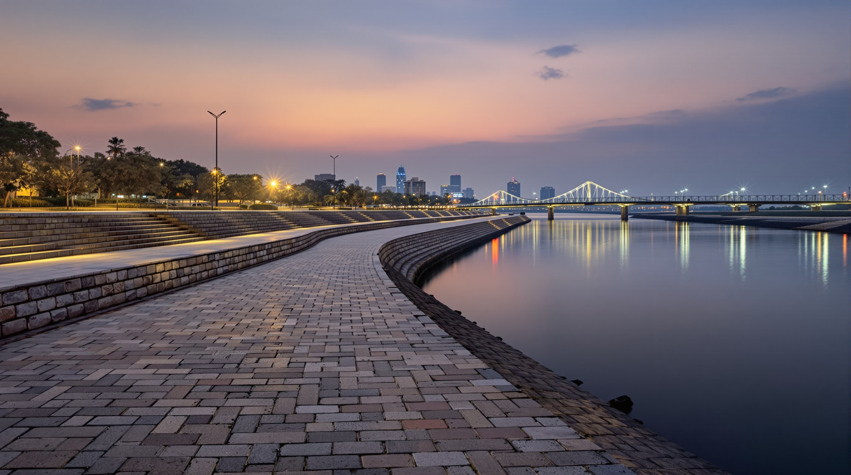
The design does not restore a river so much as compose one. A shifting seasonal bed is disciplined into a channel of constant width and constant water, and the land won from it is handed back to the city as a single, continuous, walkable edge.
The question it poses
The idea is old. As early as 1961 the French-American architect Bernard Kohn imagined an "ecological valley" along the Sabarmati, and in 1964 he proposed reclaiming around 30 hectares of riverbed for the public. Nothing was built. The vision returned, transformed, when the Environmental Planning Collaborative (EPC), led by the architect and planner Bimal Patel, prepared a feasibility study in 1998 for the Sabarmati Riverfront Development Corporation (SRFDCL) — a special-purpose company the Ahmedabad Municipal Corporation had set up in 1997. Patel's firm, HCP Design, Planning and Management, became the project's architect and lead consultant, a role it has held across two decades of construction that began in 2005 and opened its first stretches to the public in 2012.
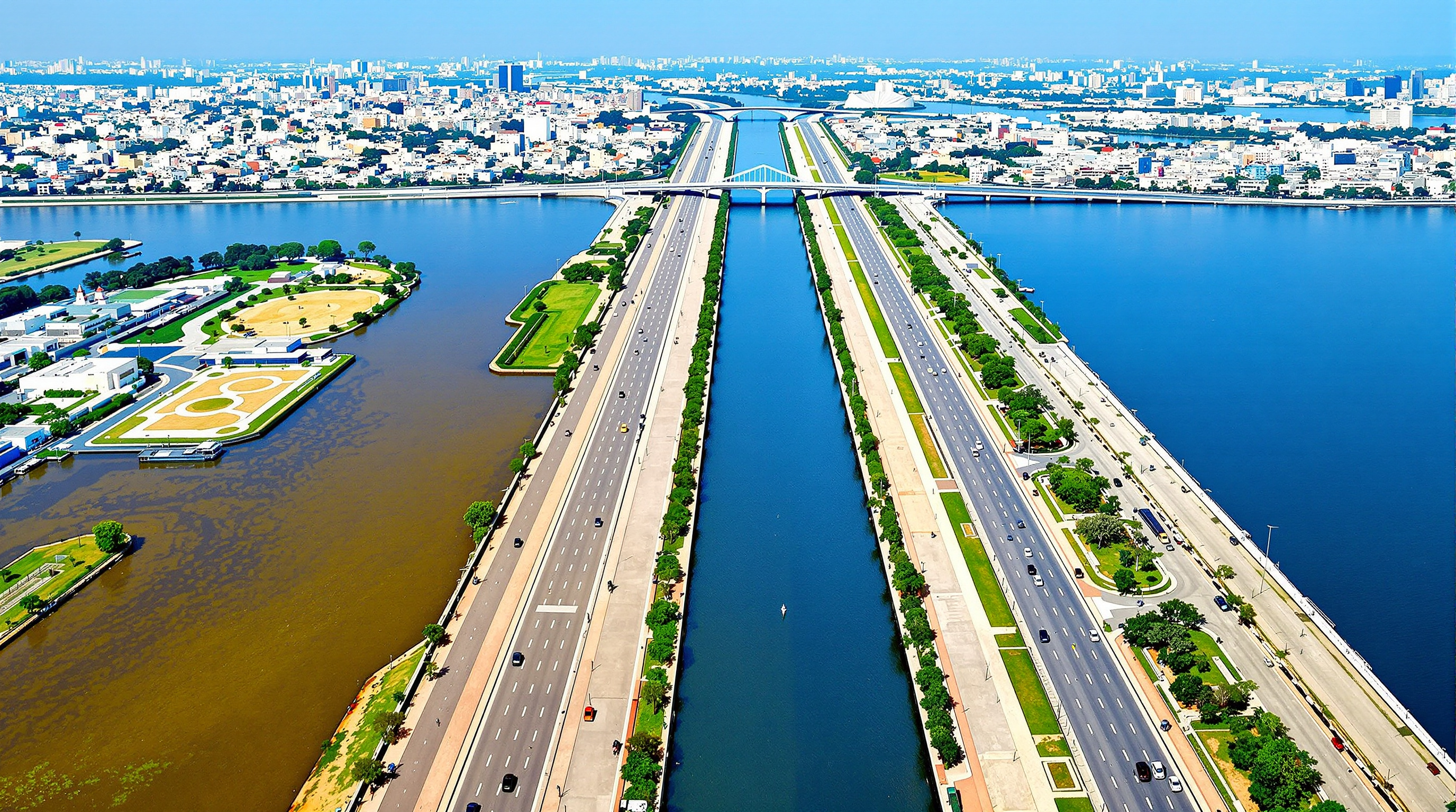
Patel's central move is a reversal of instinct. A conventional river restoration tries to re-naturalise — to widen the flood plain, soften the banks, let the water braid. The Sabarmati project does the opposite. It narrows the river to a hard-edged, uniform channel and treats the banks as architecture. The wandering bed, which varied from roughly 300 to over 400 metres wide, was disciplined to a constant width of about 263 metres. Everything outside that line — more than 200 hectares of former riverbed — was reclaimed as new public land. This is the project's future-facing provocation: that in a dense, water-stressed Indian city, the most valuable form of "nature" may not be wilderness but disciplined, accessible, equitably-shared ground — and that engineering, not preservation, is the tool that makes it.
Composing a river: the engineering
A river will not simply agree to be narrower. Confine a flood into a tighter channel and you concentrate its energy; the faster water scours the bed and undermines whatever you have built. The Sabarmati Riverfront's structural logic is entirely a response to this problem, and it is what makes the project an engineering achievement as much as a design one.
The foundation is a diaphragm wall — a deep, cast-in-place concrete wall poured into a trench excavated under a bentonite slurry, sunk more than ten metres into the riverbed along both banks. Its job is to reach below the calculated scour depth so that even when a flood claws away the bed in front of it, the wall's footing is still buried in undisturbed ground. Above and behind it sits a reinforced-concrete retaining wall, built as a counterfort-and-cantilever structure, holding back the reclaimed earth and rising several metres to keep floodwaters off the low-lying city behind. Reports give the maximum wall height above the bed as roughly twelve metres, designed against a scour depth of about five metres.
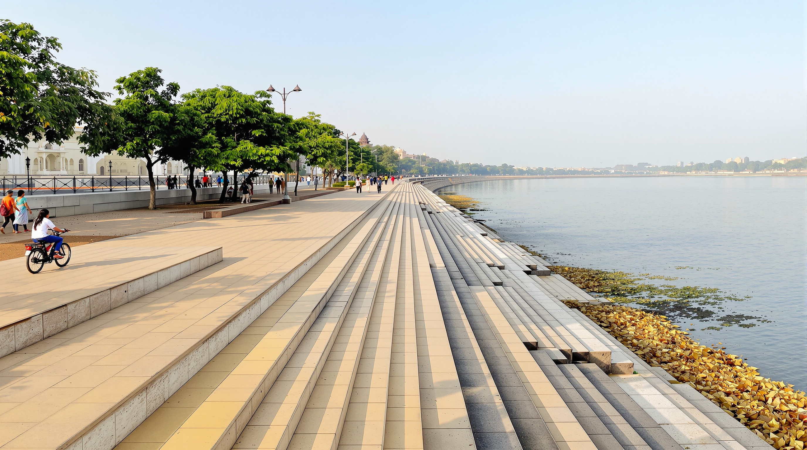
On top of this hard edge, HCP composed the project's signature architectural idea: a continuous two-level promenade. A lower walkway, six to eighteen metres wide, runs at the water's edge for the full length of each bank — an uninterrupted pedestrian and cycle route nearly 11.5 kilometres long, punctuated by thirty-one ghats (stepped access to the water) that consciously echo the riverside stairs of older Indian cities. An upper level, at city grade, carries roads, gardens, parks and the plots of new development. The genius of the section is that the flood-defence structure and the public promenade are the same object: the wall that stops the flood is the wall you walk along.
| Layer | What it does | System |
|---|---|---|
| Water channel | Constant width and level, year-round | Narrowed to ~263 m, topped up from the Narmada canal |
| Diaphragm wall | Foundation below scour depth | Slurry-trench RCC, sunk >10 m into the bed |
| Retaining wall | Holds reclaimed earth, blocks floods | Counterfort / cantilever RCC, up to ~12 m |
| Lower promenade | Continuous public edge at the water | Paved walkway, 6–18 m, ~11 km per bank |
| Upper level | City-grade roads, parks, development | Built on reclaimed land above the wall |
The self-financing logic
The engineering is only half the invention. The other half is financial, and it is the part planners in other Indian cities have studied most closely. Because the project manufactures land — more than 200 hectares of it where there was only riverbed — it also manufactures value. The SRFDCL model reserves the great majority of the reclaimed land, on the order of 85 per cent, for public and civic uses: promenades, parks, roads and infrastructure. Only a small fraction, around 14 per cent, is sold for commercial and residential development, and the proceeds are meant to repay the loans that funded the works. The public realm, in theory, pays for itself out of the land it creates. It is an elegant idea — infrastructure that captures its own value uplift — and it is precisely this self-financing promise that has made "riverfront development" a template exported from Ahmedabad to a dozen other Indian rivers.
Its Indian significance
For Indian architecture the Sabarmati Riverfront is a landmark of ambition and of professional capacity. It demonstrated that an Indian municipal body, working with an Indian firm, could conceive and deliver public infrastructure at a scale and finish previously associated with East Asian or European cities — and it won the Prime Minister's National Award for Excellence in Urban Planning and Design in 2006, before most of it was even built. It gave Ahmedabad a genuinely democratic front lawn: the promenade is free, and on any evening it fills with families, vendors, walkers and the relocated weekly Gujari market, a cross-section of the city that few Indian public spaces achieve.
It also recentred the river in the civic imagination. Bridges like the Atal pedestrian bridge turned crossings into destinations; parks, an arts-and-culture centre and event grounds gave the water a programme. In a country where riverbanks are usually either sacred ghats or informal dumping grounds, the Sabarmati proposed a third thing: the river as designed, everyday, secular public space. That template is now shaping projects on the Ganga, the Gomti, the Mula-Mutha and beyond — which makes getting the Sabarmati's lessons right a national question, not a local one.
The third position: what the wall holds back
An honest account cannot end at the promenade railing, because the land the project gave to the public was land that other people were living on. The reclaimed banks had been home to informal settlements housing tens of thousands of families. Official figures put the displaced at around 14,000 households; scholars and activists argue the true number of affected families was far higher, with some estimates reaching 40,000. Resettlement was slow, litigated in the Gujarat High Court, and by most independent assessments incomplete — many families were moved to distant peripheral housing with poor water, transport and livelihood access.
This is not a footnote to the design; it is the design's shadow. Critical scholarship has been unusually direct about it. Renu Desai's work at CEPT's Centre for Urban Equity documents the resettlement as a "post-mortem" of housing rights; Navdeep Mathur's much-cited essay in the Economic & Political Weekly reads the planning process as "totalitarian governance"; and a later study frames the project's smooth official narrative as a "missing conflict," a story from which the displaced were edited out. The same discipline that let engineers narrow a river — top-down, expert-led, decisive — is the discipline that let a public authority clear its banks with limited consent.
Studio Matrx's editorial position is to hold both truths at once. The Sabarmati Riverfront is a genuinely important piece of design and engineering, arguably the most accomplished public-realm infrastructure India has built — and a caution that "public space" is a claim, not a fact. Whose river it becomes, and who is removed to make it, is part of what the project means. A promenade is only truly public if the people it displaced can still walk on it.
Why it belongs in the canon
Strip away both the celebration and the critique, and a hard fact remains: before the Sabarmati, few cities had shown that a degraded seasonal river could be re-composed — foundation, wall, water and edge — into continuous, financed, walkable public ground at the scale of an entire urban waterfront. It is the Indian entry in a global chapter that runs from New York's High Line to Seoul's Cheonggyecheon and Madrid Río: the reclaiming of hard infrastructure as public landscape. What the Sabarmati adds to that conversation is both an engineering method and an ethical warning — and the two are inseparable. It tells us that architecture's next frontier is the ground itself, and that the ground is never empty.
References
- Sabarmati Riverfront Development Corporation Ltd (SRFDCL), "Background" and "River Promenade" — official project descriptions, dimensions and phasing. sabarmatiriverfront.com (primary source)
- HCP Design, Planning and Management, "Sabarmati Riverfront Development Project" — architect's project description (design lead: Bimal Patel). hcp.co.in (primary source, architect)
- Mathur, N. (2012). "On the Sabarmati Riverfront: Urban Planning as Totalitarian Governance in Ahmedabad." Economic & Political Weekly, 47(47/48), 64–75. (peer-reviewed / scholarly critique)
- Desai, R. (2014). Municipal Politics, Court Sympathy and Housing Rights: A Post-Mortem of Displacement and Resettlement under the Sabarmati Riverfront Project, Ahmedabad. Centre for Urban Equity, CEPT University, Working Paper. (scholarly; displacement and resettlement)
- Pessina, G. and colleagues, "The 'Missing Conflict' of the Sabarmati Riverfront: Authoritarian Governance, Neoliberalism and Water in Ahmedabad, India." Partecipazione e Conflitto. siba-ese.unisalento.it (peer-reviewed journal)
- Maccaferri, "Sabarmati River Front Development Project" — technical case study of the retaining and diaphragm wall / bank-protection works. maccaferri.com (industry / press, engineering detail)
- "Sabarmati Riverfront." Wikipedia — consolidated timeline, figures and controversy, with onward citations. en.wikipedia.org (tertiary reference)
Part of The Future of Architecture in 300 Buildings — Studio Matrx's canon of the buildings asking where architecture goes next. Chapter 13: Landscape, Public Realm & Cultural Ground.
Export this guide
Related Guides — Deep-dive reading
Cheonggyecheon Stream Restoration: How Seoul Tore Down a Highway to Uncover a River
In 2005 Seoul demolished an elevated expressway carrying 168,000 cars a day and put a 5.8-kilometre stream back in its place. This deep study reads the project's central move — subtraction as design — its pumped-water hydrology and flood engineering, its ambivalent ecology, and the politics of a restoration that never quite decided which past it was restoring.
The Future of ArchitectureHunter's Point South Park: The Waterfront That Was Designed to Flood
SWA/Balsley, Weiss/Manfredi and Arup turned an abandoned Queens shoreline into an 11-acre park that yields to the East River instead of walling it out — a working prototype for the 'soft', adaptive, resilient public realm that a warming, rising-water century now demands.
The Future of ArchitectureOne Green Mile, Mumbai: How MVRDV and StudioPOD Turned the Underside of a Flyover into Public Space
Beneath the Senapati Bapat Marg flyover in Lower Parel, MVRDV and Mumbai's StudioPOD reclaimed a strip of infrastructural dead space as a linear park of shaded rooms, monsoon-fed planting and one continuous blue-striped surface — a case study in adaptive reuse, the open-space deficit of Indian cities, and the promise and politics of privately funded public realm.
The Future of ArchitectureRelated Tools — Try Free
Apartment Video Door System Planner
Enter flats, entrances, floors and guard desk for a first-pass building intercom plan — door stations, indoor monitors, guard station, the right architecture and an indicative cost band.
Building PlannerGarden Planning Toolkit
Get a tailored garden plan — planting layers, Indian species, features and a checklist — from your climate, space, sun and goals.
PlannerInterior Project Timeline Planner
Build a week-by-week project timeline across demo, civil, joinery, finishes, and handover.
Project Planner