
The Big U: The Flood Wall That Refused to Be a Wall
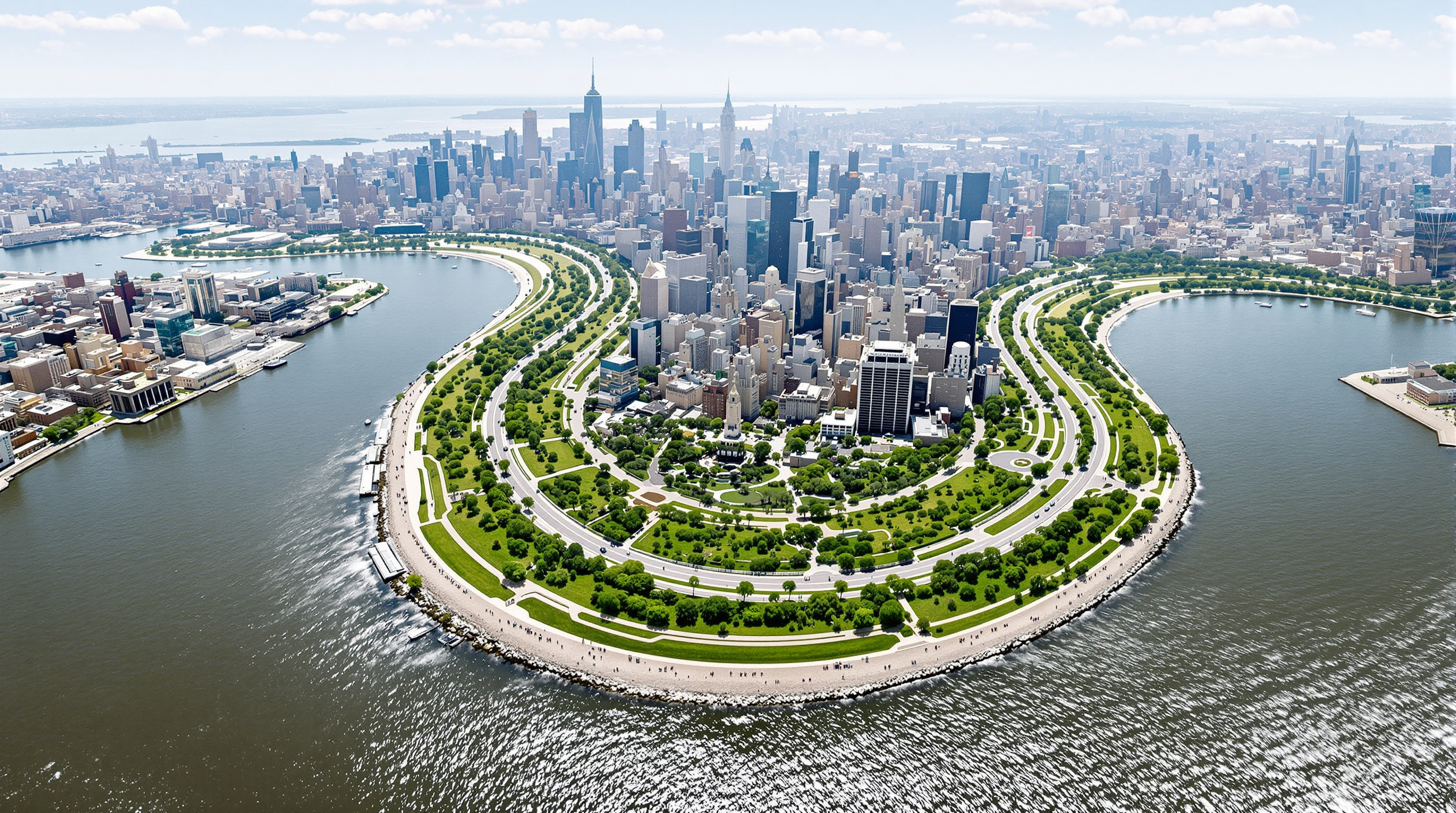
BIG and One Architecture answered Hurricane Sandy not with a barrier but with a ten-mile ribbon of raised parkland around Lower Manhattan — a 'string of pearls' where storm defence doubles as public space. This deep study reads the Big U as concept and provocation, its bridging-berm and flip-down-wall logic, and the hard gap between the visionary drawing and the East River Park it became.
In late October 2012, Hurricane Sandy pushed a wall of seawater into Lower Manhattan. The surge flooded subway tunnels, drowned electrical substations, dark-ended much of the island below 39th Street, and killed dozens across the region. When the water receded it left a question that no amount of pumping could answer: how does one of the densest, most valuable stretches of urban ground on earth defend itself against a rising, storm-prone sea without walling itself off from the very water that made it a port city in the first place?
The Big U is one answer — and it belongs in this canon less as a finished building than as a provocation, a drawing that reframed what climate-defence infrastructure could be. Developed by the Bjarke Ingels Group (BIG) with the Dutch firm One Architecture and a large consulting team, it was one of the winning entries in Rebuild by Design, the year-long competition (usually dated 2013–14) sponsored by the US Department of Housing and Urban Development in Sandy's aftermath. The BIG Team's Lower Manhattan proposal was reported to have been awarded around 335 million US dollars in initial federal funding. But the money is not why the project matters here. What matters is the idea.
"What if we could envision the resilience infrastructure for Lower Manhattan in a way that wouldn't be like a wall between the city and the water, but rather a string of pearls of social and environmental amenities?" — Bjarke Ingels, describing the Big U concept.
The question it poses
Almost every conventional coastal defence is a wall. A wall is honest about its purpose and cheap to reason about, but it exacts a brutal urban price: it severs a city from its waterfront, casts a permanent shadow of "keep out," and sits inert and ugly for the 99 percent of the time there is no storm. For a shoreline like Manhattan's — where the water's edge is also some of the most sought-after public space in the world — a wall is a defeat disguised as a defence.
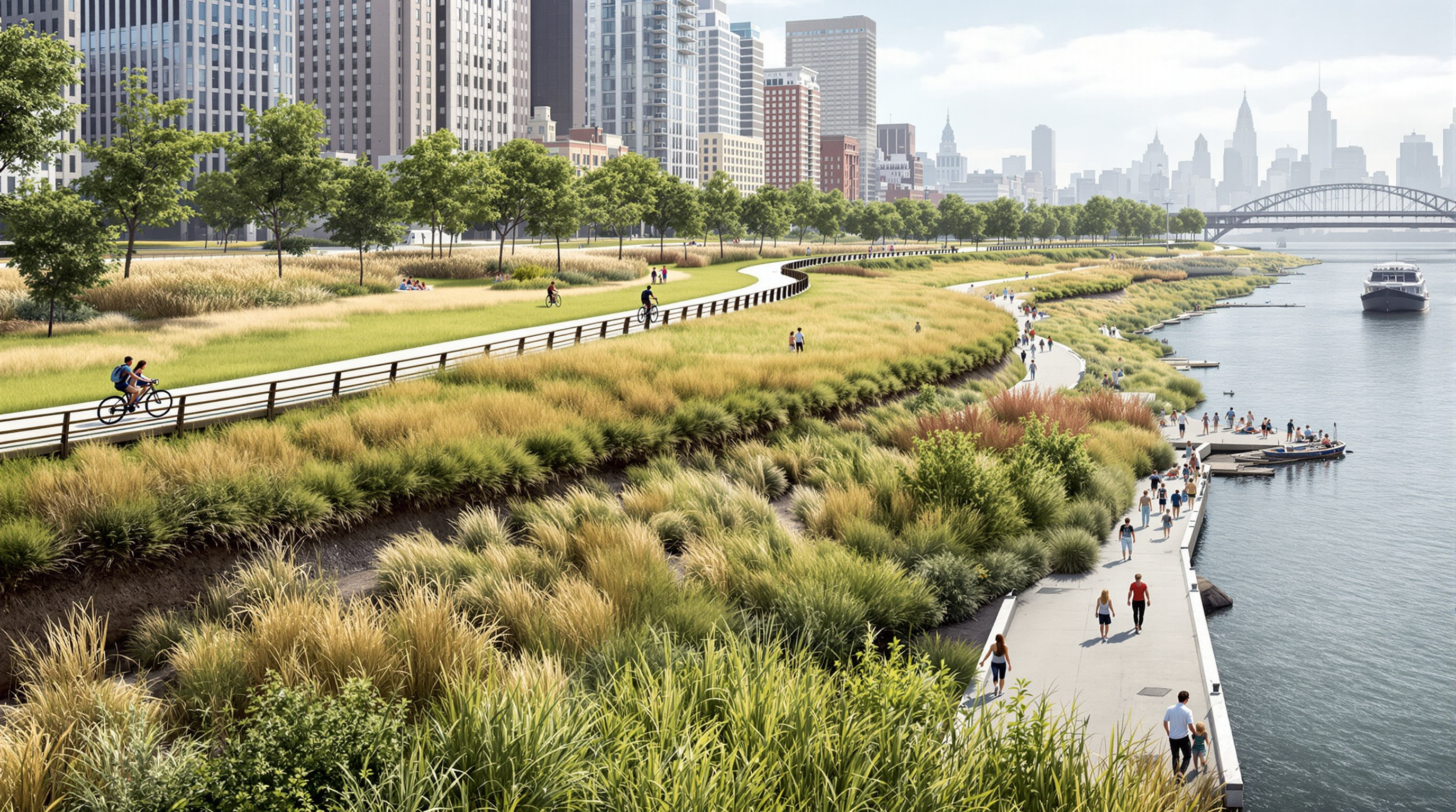
The Big U's central move is to refuse the wall as a category. Instead of a barrier laid between the city and the sea, it proposes a continuous, inhabited landscape — roughly ten miles of it — that rises just high enough to stop a surge while spending its ordinary life as park, promenade, playground and market. The protective line is drawn not as a fence but as topography: berms, raised gardens, elevated paths and cleverly disguised gates. This is the provocation that earns it a place under "Concepts & Provocations": it argues that the infrastructure of the climate century need not read as bunker or levee, but can be the best public space a neighbourhood has ever had. Protection, in this reading, is a by-product of generosity.
Compartments: the hull-of-a-ship logic
The scheme's first structural idea is organisational rather than formal. The ten-mile arc — running, as proposed, from roughly West 57th Street down around the Battery and back up the East Side toward East 42nd Street — is broken into separate compartments, each a self-contained flood-protection zone tuned to its own neighbourhood.
The designers compared this to the hull of a ship: just as a ship survives a breach because its watertight compartments keep flooding local, the Big U is engineered so that an overtopping or failure in one compartment does not cascade into the next. Each length of defence can stand alone, be funded alone, and be built alone — a pragmatic hedge that, as events proved, was prophetic. The original concept clustered the work into three principal reaches, each with its own architectural device.
| Compartment (as proposed) | Signature device | Everyday second life |
|---|---|---|
| East River Park (East Side) | The "Bridging Berm" — a raised, landscaped mound | Continuous parkland and river access over the FDR Drive |
| Two Bridges & Chinatown | Flip-down deployable panels hung under the elevated FDR | Decorated, lit ceiling for the space beneath the highway |
| Brooklyn Bridge to the Battery | The Battery Berm and upland knolls | Elevated waterfront walks; a proposed maritime museum |
The bridging berm and the flip-down wall
Two technical inventions carry the concept. The first is the bridging berm. Along the East River, the defence line is a broad, gently sculpted mound of earth planted with salt-tolerant vegetation. Because it is wide and landscaped rather than thin and vertical, it reads as rolling park, not rampart — yet its crest sits above the design flood level, so a surge meets soft, absorbent ground instead of a hard face. In places the berm is conceived to bridge over the barrier of the FDR Drive, knitting the severed neighbourhood back to its river even as it seals it against flood. It is, in spirit, a defensive earthwork masquerading as a High Line for the East Side.
The second invention solves a harder, meaner problem. Under the Two Bridges and Chinatown reach, the FDR Drive runs elevated on columns, and you cannot berm a highway. So the team proposed flip-down deployable panels: hinged flood barriers stowed flat against the underside of the highway deck, decorated on their visible faces and fitted with lighting so that, most of the time, they are simply an attractive coffered ceiling over the space beneath the road. When a surge is forecast, the panels swing down into place to close the line. It is a small, almost theatrical idea, but it encapsulates the whole thesis: the defensive element hides in plain sight as amenity until the moment it is needed.
Its place in "Concepts & Provocations"
Kushner's framing asks of every building: what does it tell us about where architecture is going? The Big U's answer is that the discipline's next great subject is infrastructure re-imagined as public generosity. For most of the twentieth century, flood walls, sea gates and levees were the property of civil engineers and were judged on a single axis — did they hold? The Big U insists on a second axis: while they are holding, are they good places to be? It folds the ambitions of landscape architecture, urban design and social equity into what had been a purely defensive object.
This lineage runs straight through BIG's own work — the High Line's model of infrastructure-as-park, the studio's "hedonistic sustainability" slogan — and outward into a global movement: Rotterdam's water squares, the Netherlands' Room for the River, China's Sponge City programme. The Big U's specific contribution was to draw this argument at the scale of a whole American downtown, with enough seduction to win federal money. As a concept, it may be the most influential unbuilt-as-drawn coastal scheme of its decade, quoted in resilience briefs from Miami to Jakarta.
The third position: what got built, and what got lost
An honest account cannot stop at the render, because the Big U as published is not the thing that is being built — and the difference is the whole controversy.
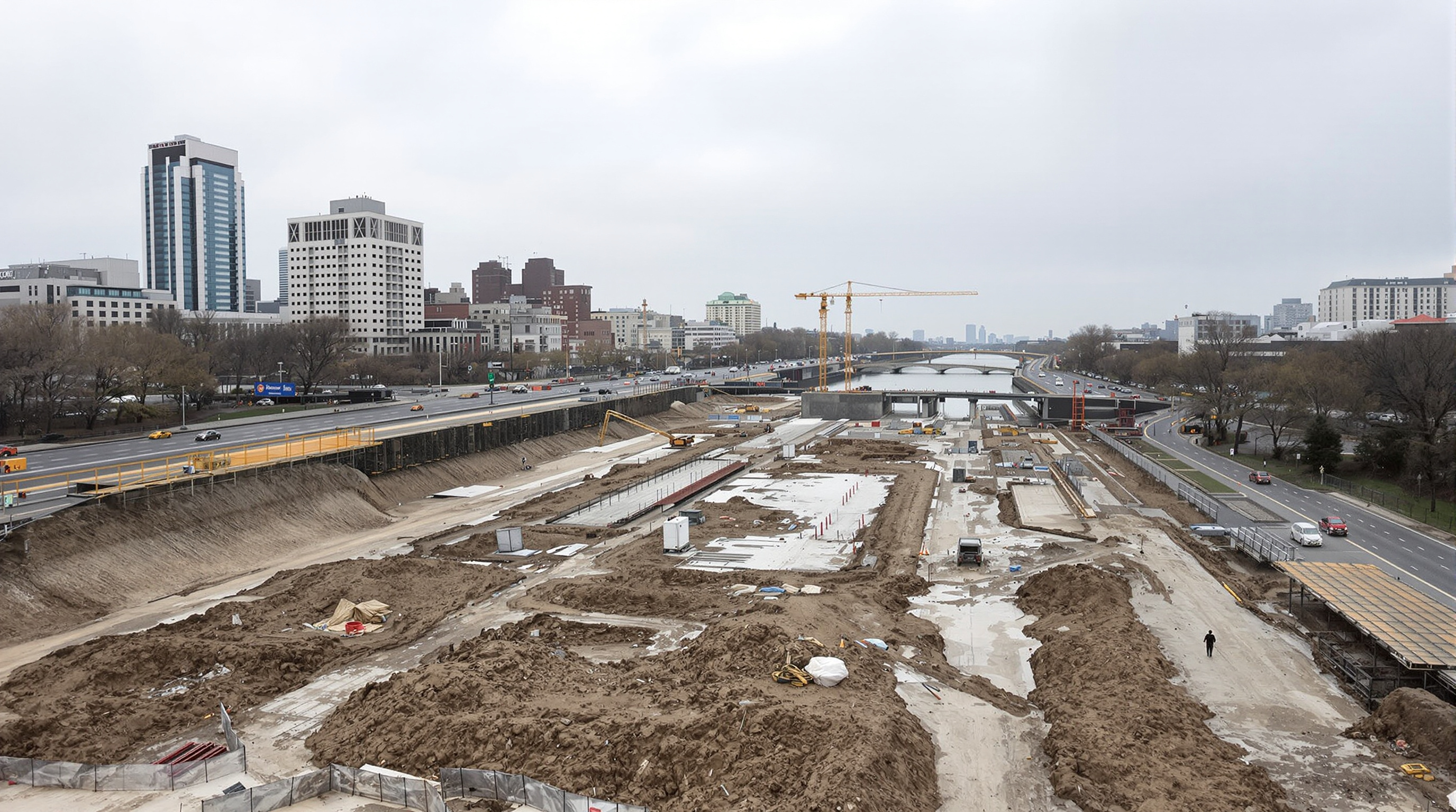
The compartment logic that made the scheme fundable also let it fracture. The East Side reach became a standalone city project, the East Side Coastal Resiliency programme (ESCR), and around 2018 the design was substantially revised. Reporting at the time described roughly 70 percent of the community-planned scheme being reworked in favour of a faster, more conventional approach: rather than build a slender berm around East River Park while keeping it open, the city chose to demolish the existing park, bury it under some eight feet of fill, and rebuild it higher on top. Construction from late 2021 onward felled a large number of mature trees — figures approaching a thousand were reported — and closed a beloved waterfront green for years.
The backlash was fierce and specific. Community groups such as East River Park ACTION fought the plan in the streets and the courts; in The Brooklyn Rail, critics called the park's destruction a "land grab" and questioned whether a "resilient" plan that begins by clear-cutting an eighty-year-old carbon sink and displacing a low-income community's only large park deserved the name. Others noted the bitter irony that a scheme conceived to avoid walling people off from the water spent its first years fencing them out of it entirely.
Studio Matrx's editorial position is to hold both truths. The Big U is a genuinely important idea — arguably the clearest built-form articulation of climate defence as public gift — and its execution is a cautionary tale about the distance between a competition render and a capital project run under emergency deadlines. The concept promised protection and park, at once. The reality, at least on the East Side, delivered them sequentially and at real human cost: park destroyed first, protection and a new park promised later. Both facts are part of what the Big U teaches. The provocation was right; the warning is that a beautiful section drawing is not, by itself, a governance model.
Why it belongs in the canon
Strip away the render and the litigation, and a durable proposition remains: the infrastructure that will define the climate century does not have to be defensive, ugly or exclusionary. It can be the best ground a city has. The Big U proved that such a vision could be drawn compellingly enough to move federal money and reset the terms of a whole discourse — and its troubled realisation proved, just as usefully, that the hard part was never the concept. The hard part is keeping the promise the drawing makes. That double lesson is exactly why it earns its place among the provocations asking where architecture goes next.
References
- Rebuild by Design, "The Big U" — official project page, funded projects (BIG + One Architecture team; concept, compartments, funding). rebuildbydesign.org (primary source)
- BIG (Bjarke Ingels Group) & One Architecture, "BIG U / Rebuild by Design" project description — the "string of pearls," bridging berm and hull-of-a-ship compartment logic. archello.com/project/big-u (primary / architect source)
- US Department of Housing and Urban Development, Rebuild by Design competition (2013–2014), winning proposals and awards. Summarised at rebuildbydesign.org (primary — government programme)
- American Planning Association, "The BIG U" — 2015 award citation and project summary. planning.org/awards/2015/bigu.htm (primary — institutional)
- Keil, M. (2022). "Land Grab." The Brooklyn Rail, Field Notes, February 2022. brooklynrail.org (press / critical essay — the ESCR controversy)
- "BIG U flood defences for Manhattan move forward." Dezeen (2018). dezeen.com (architectural press — the 2018 ESCR redesign)
- "East Side Coastal Resiliency project is halfway done." The Architect's Newspaper (2024). archpaper.com (architectural press — construction status)
Part of The Future of Architecture in 300 Buildings — Studio Matrx's canon of the buildings asking where architecture goes next. Chapter 16: Concepts & Provocations.
Export this guide
Related Guides — Deep-dive reading
The Big U: How BIG Turned a Flood Wall into a Ten-Mile Public Park
BIG and One Architecture answered Hurricane Sandy with a protective 'U' wrapping Lower Manhattan — a berm that is also a park, a bench that is also a barrier. A deep study of the 'string of pearls' concept, the compartments and deployable panels that make it work, and the hard gap between the drawing and what New York actually built.
The Future of ArchitectureHunter's Point South Park: The Waterfront That Was Designed to Flood
SWA/Balsley, Weiss/Manfredi and Arup turned an abandoned Queens shoreline into an 11-acre park that yields to the East River instead of walling it out — a working prototype for the 'soft', adaptive, resilient public realm that a warming, rising-water century now demands.
The Future of ArchitectureThe Lowline: Can You Pipe Sunlight Underground and Grow a Public Park?
Raad Studio's proposal to turn a derelict trolley terminal beneath Manhattan's Lower East Side into the world's first subterranean park is one of the most influential buildings never built — a test of remote-skylight technology, of found infrastructure as raw material, and of whether an idea can shape architecture even when the money runs out.
The Future of ArchitectureRelated Tools — Try Free
Concept Generator
Get 3 AI-generated design concepts for any room with style, materials, and cost estimate.
DesignAIFalse Ceiling Cost Estimator
Live ₹/sqft across 8 ceiling types — POP, gypsum, designer, metal, PVC, wooden — with cove and spot lighting for 20 Indian cities.
Cost CalculatorBefore & After Studio
Generate AI before-and-after renders to preview how your redesign could look.
DesignAI