
Introduction to Urban Design
The discipline of the space between buildings, and how to read city form.
Architecture designs the building; town planning draws the land-use map; urban design works in the gap — it designs the space between buildings, the public realm and the three-dimensional form of the city. Named as a discipline at the 1956 Harvard conference, it is the art of arranging buildings and spaces in relation to one another. This first unit teaches you to read city form: the figure-ground relationship and the Nolli map, townscape elements, urban scale and massing, and the quality of urban enclosure — the width-to-height (D/H) ratio that decides whether a street feels like an outdoor room or an empty void.
Learning objectives
By the end of this lesson, you will be able to — mapped to the course outcomes for Urban Design:
Distinguish urban design from architecture and town planning by scale and what it uniquely addresses.
Read city form through the figure-ground relationship and the Nolli-map idea of the continuous public realm.
Explain urban scale, massing, townscape and behavioural use of space.
Use the width-to-height (D/H) ratio to judge the quality of urban enclosure of a street or square.
Three disciplines, three scales
Architecture designs the building, planning draws the regional land-use map, and urban design works in between — designing the public realm, the space between buildings.[1, 9]
Building → public realm → region
Three disciplines work at three scales. ARCHITECTURE designs the single building and its interior — the object, the figure. TOWN/CITY PLANNING works at the regional and statutory scale — two-dimensional land use, zoning, transport networks, demographics and the master plan. URBAN DESIGN sits in between: it designs the space BETWEEN buildings — streets, squares, the public realm, the grouping and massing of buildings, and the three-dimensional form of the city. It works in the gap that architecture (too small) and planning (too abstract and flat) each leave open.[1, 9]
Reading city form
Urban design's most basic drawing is the figure-ground — reading the city as solid mass and open void. The Nolli map of Rome (1748) rendered the whole public realm, even building interiors, as continuous white.[2, 9]
Solid and void
The figure-ground relationship reads the city as a reciprocal pattern of built mass (figure/solid, drawn black) and open space (ground/void, drawn white). Inverting which is figure and which is ground reveals the STRUCTURE of the public realm — whether the open spaces form a connected system or are just left-over gaps. It is urban design's most basic analytical drawing.[2, 9]
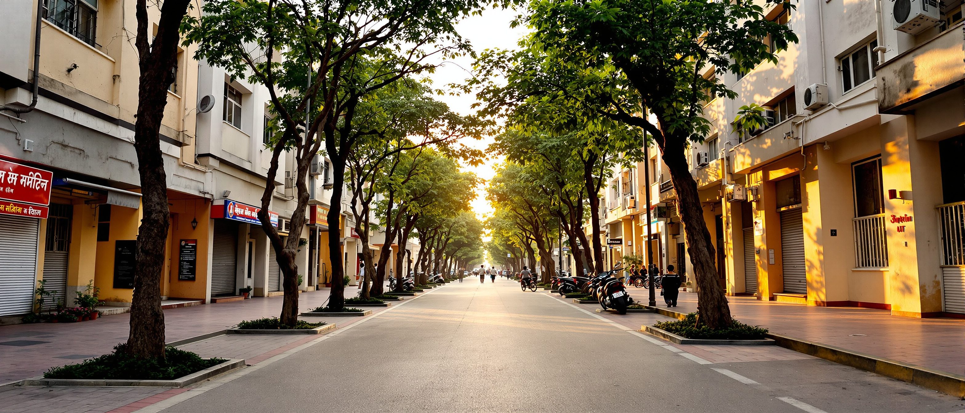
Does this street feel enclosed?
Set a street's width and the height of its enclosing walls, and watch the width-to-height (D/H) ratio classify the quality of enclosure — intimate, balanced, open, or lost.
Quality of enclosure · move the sliders
1.20
D / H ratio
Balanced
enclosure
Ashihara's comfortable range — you read both the buildings and the sky; the classic feel of a good street or square.
street section
Indicative — D/H thresholds are perceptual heuristics (Ashihara; Lynch), not fixed laws.
At a glance
| Aspect | One | The other |
|---|---|---|
| Scale | Architecture: the single building | Urban design: the space between buildings |
| Dimension | Town planning: 2-D land use, policy | Urban design: 3-D form, experienced |
| Primary material | Architecture: the object / figure | Urban design: the public realm / void |
| Judged by | Architecture: the building's quality | Urban design: how the place is used |
| Enclosure heuristic | Myth: D/H is a fixed law | Reality: a perceptual rule of thumb — cite the author |
Key terms
The design of the space between buildings — the public realm and three-dimensional city form, between architecture and planning.
The network of streets, squares and open spaces accessible to all — urban design's primary material.
A drawing reading the city as solid (built figure) versus void (open ground) to reveal the structure of space.
Giambattista Nolli's figure-ground map of Rome that rendered all public space — even building interiors — as continuous white.
Cullen's art of giving visual coherence to the everyday urban scene at eye level.
The perceived size of spaces and elements relative to the human body and movement.
The three-dimensional bulk, height and grouping of building volumes and the voids they shape.
Width-to-height ratio of a street/square; a perceptual gauge of enclosure (≈1 balanced; >4 enclosure lost).
Studio task
Pick a street or square you know well. Sketch its figure-ground (buildings black, spaces white) for one block. Then estimate its width-to-height ratio with the enclosure explorer and say whether it feels intimate, balanced or open — and whether that matches how the place actually feels to walk through. Note one thing the urban design (not the architecture) could do to improve it.
Self-assessment
1. Urban design is best described as the design of —
2. The 1748 Nolli map of Rome is the canonical example of —
3. A street with a width-to-height (D/H) ratio of about 1 generally feels —
Recap
References & further reading
- [1]Carmona, M., Heath, T., Oc, T. & Tiesdell, S. — Public Places, Urban Spaces: The Dimensions of Urban Design (Architectural Press, 2003).
- [2]Nolli, Giambattista — La Nuova Pianta di Roma (figure-ground map of Rome), 1748.
- [3]Cullen, Gordon — The Concise Townscape (Architectural Press, 1971; first as Townscape, 1961).
- [9]Spreiregen, Paul D. — Urban Design: The Architecture of Towns and Cities (McGraw-Hill, for the AIA, 1965).
- [10]Watson, D., Plattus, A. & Shibley, R. (eds.) — Time-Saver Standards for Urban Design (McGraw-Hill, 2003).
- [11]Ashihara, Yoshinobu — The Aesthetic Townscape (MIT Press, English ed. 1983) — the D/H enclosure ratio.
Further reading
- Paul D. Spreiregen — Urban Design: The Architecture of Towns and Cities (1965).
- Matthew Carmona et al. — Public Places, Urban Spaces (2003).
- Yoshinobu Ashihara — The Aesthetic Townscape (1983).
Sources gathered and fact-checked June 2026. Published values vary by source, sample and method — treat as indicative and confirm against the cited standard before structural use.
The author
Amogh N P
Architect, interior designer, and creative polymath. Studio Matrx began in his notebooks — his vision of design made honest, useful, and open to everyone. Its Academy is written and taught in his memory, and free, forever.
More about Amogh →