
11 · The Americas & Africa (Pre-Modern)No. 01 in era
Teotihuacan (Pyramid of the Sun)
On the floor of the Valley of Mexico, an unknown people laid out a whole city as a single work of architecture — a rigorous grid ordered by one colossal axis, the Avenue of the Dead. Along it rose the Pyramid of the Sun, the third-largest pyramid on Earth: a mountain of adobe and rubble, skinned in cut stone and painted stucco, and raised over a sacred cave.
1. A city planned around one axis
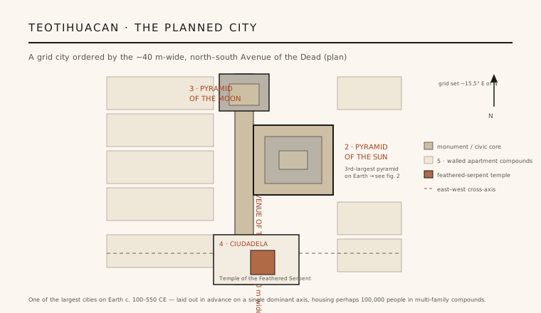
Teotihuacan is one of the earliest and clearest demonstrations that a city could be composed as a single work of architecture. Around the start of the Common Era its unknown builders laid out, in advance, a vast urban plan on the floor of the Valley of Mexico and held to it for centuries. The organising device is the Avenue of the Dead — a ceremonial boulevard roughly 40 metres wide running north–south for more than two kilometres, its orientation fixed about 15.5 degrees east of true north. Everything else in the city takes its bearing from this line.
The avenue is not merely a street but the spine of a gridded metropolis. The Pyramid of the Moon closes its northern end; the colossal Pyramid of the Sun stands on its eastern side; and to the south the great sunken enclosure of the Ciudadela, containing the Temple of the Feathered Serpent, marks where the main axis meets an east–west cross-axis. Around this armature the city fabric was set out in a disciplined grid of blocks — an act of centralised planning on a scale the pre-Columbian Americas had never seen.
2. The Pyramid of the Sun — a mountain of earth and rubble
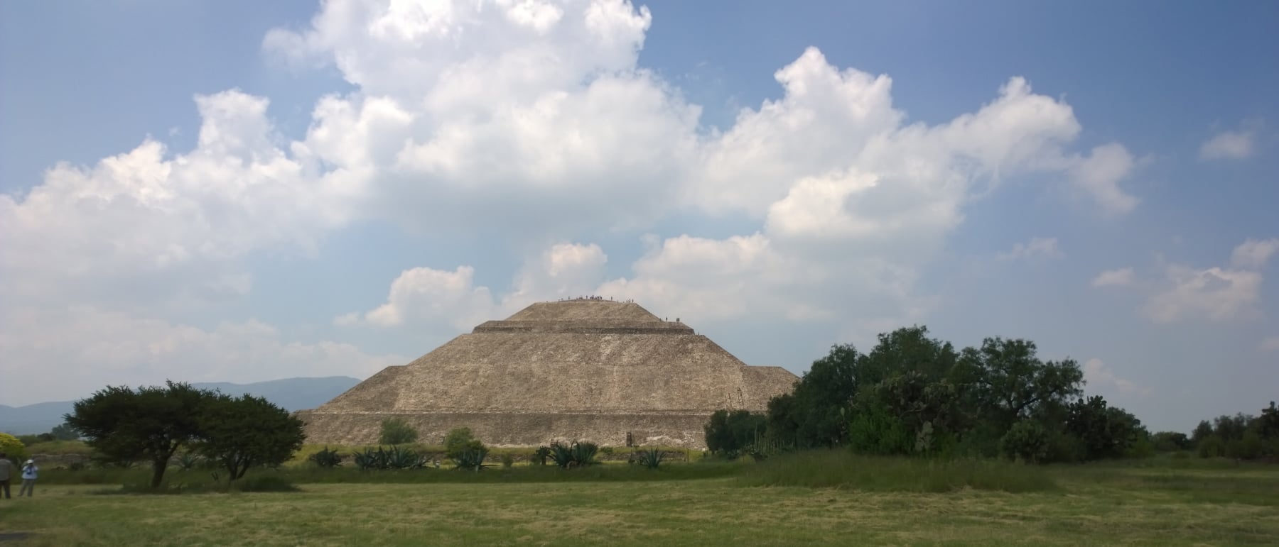
The Pyramid of the Sun is the largest structure at Teotihuacan and, by volume, the third-largest pyramid in the world, after the Great Pyramid of Cholula and the Great Pyramid of Giza. It rises about 65 metres in a series of stepped terraces from a base roughly 225 metres square, containing on the order of a million cubic metres of material. A broad frontal stair once climbed its west face to a summit temple that has since vanished; what survives is the terraced mass itself.
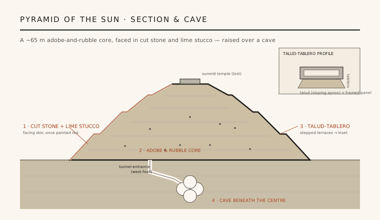
For all its bulk, the pyramid is not solid masonry. Its core is an immense fill of adobe (sun-dried mud brick), rubble and earth — cheap, abundant material moved and tamped by hand in staggering quantity. Over this core the builders laid a structural skin of cut volcanic stone bedded in mortar and finished in lime stucco, originally painted, probably in deep red. The engineering lesson is economy: a monument of mountainous scale raised from earth and rubble, with fine stone reserved for the thin visible surface.
3. Talud-tablero, and the cave beneath
Teotihuacan gave Mesoamerica its signature wall articulation: the talud-tablero. Each terrace combines a talud — an inward-sloping apron or batter — with a tablero, a vertical rectangular panel set above it inside a projecting frame. Repeated up a facade, the profile turns a stepped mass into a rhythm of shadow and light, of load and frame. The system proved so effective as a civic style that it travelled far beyond the city, appearing at Maya centres such as Tikal and Kaminaljuyu that lay within Teotihuacan's cultural and commercial orbit.
Beneath the Pyramid of the Sun lies its strangest feature. In 1971 archaeologists found a tunnel running east from the foot of the west stair to a four-lobed, cloverleaf chamber directly under the pyramid's centre — a partly natural lava-tube cave, enlarged by human hands. In Mesoamerican thought caves were places of emergence and origin, the womb from which peoples and the sun itself were born. Many scholars argue the pyramid was deliberately sited over this cave as an axis mundi, so that the monument rose from a mythic point of creation — though how much of the cave is natural, and exactly what it meant, remain debated.
4. Apartment compounds and the urban invention
What made Teotihuacan a true city rather than a ceremonial precinct was its housing. Beyond the monuments, René Millon's mapping in the 1960s revealed more than two thousand single-storey walled apartment compounds — rectangular residential blocks, each holding several households around shared central patios, with plastered floors, drainage and, in the finer examples, brilliantly painted murals. Families lived, worked and worshipped within these compounds; some — the so-called Oaxaca and Merchants' barrios — housed distinct ethnic communities, making the city notably multi-ethnic.
This standardised, multi-family compound is an urban invention in its own right: a repeatable module that let a planned grid absorb a huge population at high density while preserving privacy and order. At its peak around 400 CE the city covered some 20 square kilometres and held perhaps 100,000 people or more, ranking among the largest cities anywhere on Earth at the time. Teotihuacan shows that monumental planning and everyday domestic architecture could be conceived as parts of one system.
5. Architecture without a name
For all its scale and order, Teotihuacan is architecture without a named author. We do not know what its builders called themselves, what language they spoke, or how they governed; even the name Teotihuacan is Nahuatl, given centuries later by the Aztecs, who found the city already an ancient ruin and read it as the place where the gods were created. Pyramid of the Sun and Avenue of the Dead are likewise Aztec labels, not original names — and even the pyramid's present outline owes much to a heavy, controversial restoration by Leopoldo Batres for Mexico's 1910 centenary.
The end is as obscure as the beginning. Around 550 CE the ceremonial heart of the city was deliberately burned and its monuments desecrated, and the great metropolis declined — whether through internal revolt, drought, environmental stress or some combination, no one can yet say. Inscribed by UNESCO in 1987, Teotihuacan endures as one of humanity's boldest experiments in urban form: a whole city composed as a single, oriented, monumental design by people who left us their architecture but not their name.
The idea of composing an entire capital around one monumental ceremonial axis — a broad central spine terminating in landmark structures — reappears in planned cities from Washington's National Mall to Lutyens's New Delhi and Brasília, all descendants of the axial urbanism Teotihuacan perfected two thousand years ago.
References & further reading
- 01Millon, R. (1973). Urbanization at Teotihuacan, Mexico, Vol. 1: The Teotihuacan Map. University of Texas Press, Austin.
- 02Cowgill, G. L. (2015). Ancient Teotihuacan: Early Urbanism in Central Mexico. Cambridge University Press.
- 03Sugiyama, S. (2005). Human Sacrifice, Militarism, and Rulership: Materialization of State Ideology at the Feathered Serpent Pyramid, Teotihuacan. Cambridge University Press.
- 04Heyden, D. (1975). An Interpretation of the Cave underneath the Pyramid of the Sun in Teotihuacan, Mexico. American Antiquity 40(2), 131–147. https://doi.org/10.2307/279609
- 05UNESCO World Heritage Centre (1987). Pre-Hispanic City of Teotihuacan (Criteria i–vi). UNESCO World Heritage List, no. 414. https://whc.unesco.org/en/list/414/
Last verified 2026-07-06. Ancient and vernacular works often have no single architect or firm date; dates are given as widely accepted approximations and the builder-culture is named where no individual designer is known.