
26 · Vernacular, Gardens & Engineering WondersNo. 15 in era
Dujiangyan Irrigation System
A 2,000-year-old machine made of river, stone and gravel. Built around 256 BCE, the Dujiangyan works still water the Chengdu plain today — and they do it without a dam, guiding the Min River rather than blocking it.
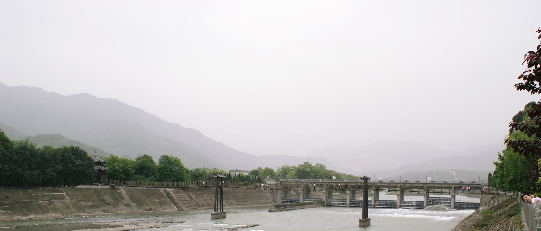
1. A machine with no moving parts
Most great waterworks of the ancient world are walls: a dam thrown across a river to hold it back. Dujiangyan is the opposite. Around 256 BCE, Li Bing, the Qin governor of the Shu region, faced a river that alternately flooded the Chengdu basin and left it parched. His answer, built with his son and generations of labour, was not to stop the turbulent Min but to divide it — to shape the landscape so that the water sorted itself. The result is less a building than a piece of terrain engineered to behave, and it is arguably the oldest large-scale hydraulic system on Earth still doing the job it was designed for.
The genius of the scheme is that it has almost no mechanism. There are no gates to raise, no sluices to time, no dam to fail. Three simple, massive earth-and-stone works — a levee, a spillway and a cut through a mountain — sit in the current and let the river's own depth, speed and curvature do the deciding. Understanding Dujiangyan means understanding how those three forms cooperate, so that flood water is shed, silt is flushed, and a measured, dependable stream is delivered onto the plain.
2. The Fish Mouth — a levee that proportions the river
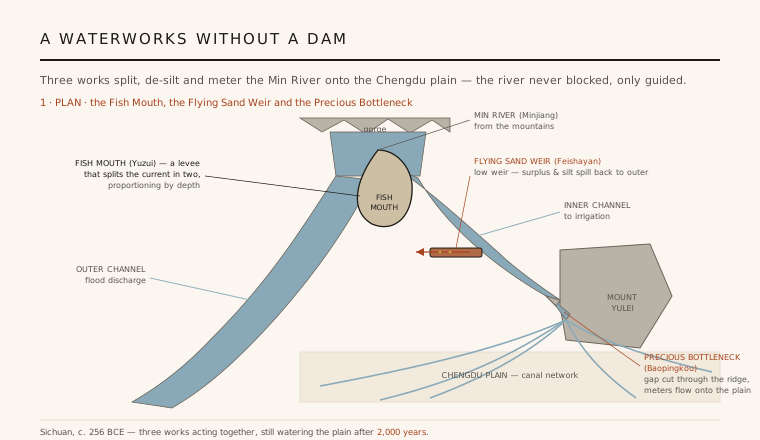
The first and central work is the Yuzui, the "Fish Mouth," a long artificial levee whose rounded, pointed nose faces upstream and splits the oncoming Min like the prow of a boat. To one side it sends water into the Outer Channel (Waijiang), which follows the river's natural course and serves to carry flood away. To the other it feeds the Inner Channel (Neijiang), the artificial arm that leads to the irrigation network. What makes the levee more than a simple divider is the shaping of the two beds: the inner channel is dug narrower and deeper, the outer left wider and shallower.
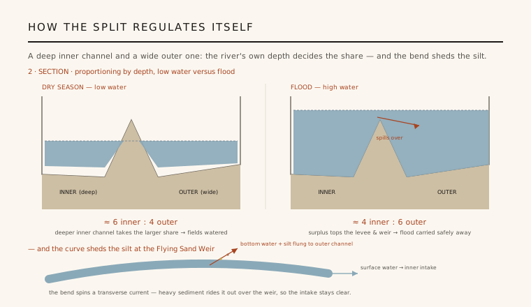
Because of that difference in depth, the split is self-adjusting. In the dry season, when the river runs low, the deeper inner channel captures the larger share — traditionally described as a roughly six-to-four division in favour of irrigation — so the fields keep their water. In flood, when the level rises, the wide outer channel and the works below it take the greater volume, reversing the ratio to about four-to-six and shunting the dangerous surplus away from the plain. The Chinese engineering tradition preserves this as the principle of fēnshuǐ — dividing the water — a proportioning done entirely by the geometry of the beds and the height of the water, with no operator at all.
3. The Flying Sand Weir — shedding water and silt
A river carrying the sediment of a mountain range will silt up any intake within a few seasons; this is what usually kills ancient canals. Dujiangyan defeats it with the second work, the Feishayan or "Flying Sand Weir," a low overflow spillway set in the bank between the inner channel and the outer channel, just above the intake. When the inner channel fills beyond a certain level, the excess simply pours sideways over this low weir and back into the outer flood channel — a second, automatic release of surplus water on top of the Fish Mouth's split.
The weir's cleverness lies in where it sits: on the outer side of a bend in the flow. As the current sweeps round the curve, the faster surface water carries on toward the intake while a transverse, corkscrewing current drives the heavier bottom water — laden with sand and gravel — up and out over the low weir into the outer channel. In effect the bend flings the silt away, giving the weir its name. The traditional accounting held that the great majority of the sediment is expelled here, which is why the intake below stays navigable and clear. It is a de-silting device with no filter, screen or moving part — only the physics of water rounding a curve.
4. The Precious Bottleneck — metering the flow
The inner channel finally reaches the third work, the Baopingkou or "Precious Bottleneck": a narrow gate hand-cut straight through a rocky spur of Mount Yulei. Li Bing's crews, working before gunpowder or iron blasting, are said to have split the hard rock by heating it with fire and then dousing it with water until it cracked — a labour that reportedly took some eight years to open the gap. The cut is deliberately, permanently narrow, roughly twenty metres across the water, and it forms the single controlled doorway between the system and the Chengdu plain.
That fixed width is itself a regulator. Because the opening cannot widen, there is a ceiling on how much water can ever pass onto the plain, no matter how high the flood behind it climbs; anything the bottleneck refuses is backed up and forced over the Flying Sand Weir into the outer channel. So the three works form a chain of automatic controls — split, spill, meter — each catching what the one before could not, and each using nothing but the shape of stone and the level of the water. Beyond the gate the flow fans out into a spreading web of canals that turned a flood-prone basin into one of the most productive agricultural regions in China.
5. Why it still matters
Dujiangyan is a standing rebuttal to the idea that controlling a river means overpowering it. Where a dam concentrates force behind a single structure whose failure is catastrophic, Li Bing's system distributes the work across cooperating landforms that have no single point of failure and no reservoir to burst — a resilience proven by more than two millennia of monsoons and earthquakes, including the 2008 Wenchuan quake, which the ancient works largely survived. Its maintenance, too, is built into the design: each winter the channels were traditionally closed and dredged in turn, guided by simple stone markers Li Bing is credited with leaving to show the right depth.
For the discipline of architecture and engineering, the system's lesson is that structure and site can be one and the same — that the most durable intervention may be a shaping of the ground that turns natural forces into collaborators rather than adversaries. Much of what we now call ecological or "soft" engineering, working with water rather than against it, was demonstrated here in the third century BCE. Recognised by UNESCO in 2000 and still irrigating millions of hectares, Dujiangyan remains the clearest proof that the best waterworks can be, in the end, an act of landscape design.
Every modern "room for the river" and living-shoreline scheme that tames floods by guiding water instead of walling it off is rediscovering the logic Li Bing built into the Min more than two thousand years ago.
References & further reading
- 01UNESCO World Heritage Centre (2000). Mount Qingcheng and the Dujiangyan Irrigation System. World Heritage List, inscription no. 1001. https://whc.unesco.org/en/list/1001
- 02Needham, J., Wang, L. & Lu, G.-D. (1971). Science and Civilisation in China, Vol. 4, Part 3: Civil Engineering and Nautics. Cambridge University Press, pp. 288–296.
- 03Li, K. & Xu, Z. (2006). Overview of Dujiangyan Irrigation Scheme of Ancient China with Current Theory. Irrigation and Drainage 55(3), pp. 291–298.
- 04Cao, S., Wang, X. & Cao, W. (2010). Chinese History and Agriculture: The Dujiangyan Irrigation System. in Sustainable Development of the Chengdu Plain, environmental history literature.
- 05Willmott, W. E. (1989). The Dujiangyan: An Ancient Chinese Irrigation System. The Geographical Journal / regional geography surveys of Sichuan.
Last verified 2026-07-11. Ancient and vernacular works often have no single architect or firm date; dates are given as widely accepted approximations and the builder-culture is named where no individual designer is known.