
1 · First Foundations (Prehistory & the Ancient Near East)No. 07 in era · ▸ India
Dholavira (planned city)
On a parched island in the salt desert of Kutch, the Harappans cut a whole city out of stone and organised it around a single obsession: catching and keeping every drop of water. Dholavira is the Indus Valley's masterwork of hydraulic urbanism — and, since 2021, a UNESCO World Heritage Site.
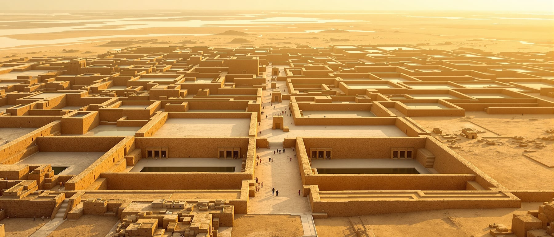
1. A city planned as three walled parts
Dholavira is one of the clearest surviving demonstrations of Harappan town-planning as a deliberate hierarchy. Excavations led by R. S. Bisht for the Archaeological Survey of India revealed a tripartite scheme within one great fortified rectangle roughly 771 by 617 metres: a heavily defended citadel at the south, a walled middle town, and an outer lower town. The citadel itself splits into two — the castle, the strongest and most elaborately walled precinct, and an adjoining bailey, a residential annexe for what were presumably the elite or governing households.
What makes the plan read as architecture rather than accretion is its geometry. The enclosures are laid out with consistent proportions and cardinal orientation, gateways are placed on axis, and a large open ceremonial ground — a stadium-like rectangle — separates the citadel from the middle town, choreographing movement and assembly. This is a city composed in advance, its social order written into walls, thresholds and reserved open space.
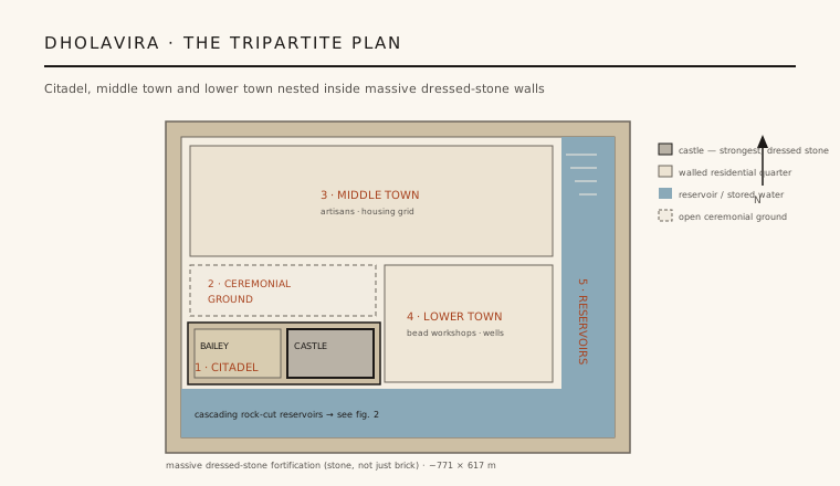
2. Built of stone, not just brick
The great Indus cities of the Punjab and Sindh — Harappa, Mohenjo-daro — are essentially brick cities, built from the standardised baked and mud bricks that are a hallmark of the civilisation. Dholavira is the striking exception. Sitting on a stone-rich island, its builders quarried and dressed local stone for the massive fortification walls, gateways and structural cores, reserving mud-brick and brick for superstructure and infill. In places the fortification walls are many metres thick at the base.
This shift in material changes the architectural character. Stone let the Harappans build steeper, more monumental defensive walls and finely finished gateways — including a north gate that yielded a signboard of large gypsum-inlay Indus signs, among the earliest monumental inscriptions known. Dholavira shows that Harappan urbanism was not a single template mechanically repeated but a system adapted to local geology, using whatever the land offered while keeping the underlying planning logic intact.
3. Water engineering as the organising principle
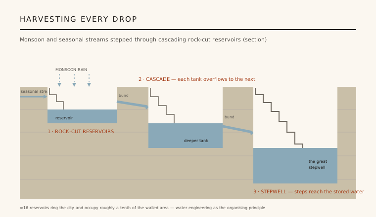
Dholavira sits in one of the driest, most saline landscapes on the subcontinent, fed only by monsoon rain and two seasonal streams, the Manhar and Mansar, that flow for a few weeks a year. The Harappan response was to turn the entire city into a water-harvesting machine. They dammed the streams with bunds, channelled the runoff, and stored it in a series of enormous rock-cut and masonry reservoirs — around sixteen of them — that ring the settlement and occupy roughly a tenth of the walled area.
The reservoirs are arranged as a cascade: water captured at higher points overflows and feeds the next tank down, so that little is lost and storage is maximised across the seasons. Access to the stored water was engineered too, through flights of steps and rock-cut stepwells descending to the shifting water level — the eastern reservoir contains one of the most impressive early stepped water structures known. Here water management is not an amenity bolted onto the city; it is the generating idea around which the plan, the earthworks and the defences were shaped.
4. The grid, the drains and the standardised city
Inside the walls, Dholavira follows the disciplined Harappan grid: streets meeting at planned intersections, blocks of rooms around courtyards, and a comprehensive network of covered drains and soak-pits that carried storm and waste water away. Wells were sunk across the quarters, and channels moved water from reservoir to street and building. The same concern for hygiene, circulation and the equitable distribution of water that defines Mohenjo-daro is present here — expressed in stone.
Standardisation runs through the fabric: consistent brick and stone modules, repeating structural details, and dimensioned enclosures suggest shared measurement and centralised planning across a very large site. For historians of the discipline, Dholavira is compelling evidence that the world's earliest large-scale urban planning was not confined to a couple of famous capitals but was a portable body of knowledge, capable of being re-engineered for a hostile desert island.
5. Decline, rediscovery and World Heritage
Dholavira was occupied for well over a millennium, from around 3000 BCE, through the mature Harappan peak of roughly 2500–1900 BCE, into the civilisation's long de-urbanisation. As monsoon patterns weakened and the streams and Rann shifted, the very water regime the city was built to exploit turned against it; the later phases show simpler, smaller structures before the site was finally abandoned. The dating and the causes of decline are read from stratigraphy and are, as with much of the Bronze Age, approximate — but the arc from planned metropolis to modest settlement is clear.
The mound was excavated systematically by the ASI from 1989, and in 2021 UNESCO inscribed Dholavira: A Harappan City on the World Heritage List, citing its exceptional water-management system, its multi-layered fortifications and its sophisticated stone architecture. Its lasting lesson for architecture is stark and modern: in a place with almost no reliable water, the Harappans built a great city by making water storage the first act of design rather than the last.
Every contemporary 'sponge city' and water-sensitive urban design — landscapes engineered to capture, store and cascade monsoon runoff instead of shedding it — is rediscovering the principle Dholavira built into stone four and a half thousand years ago.
References & further reading
- 01Bisht, R. S. (2015). Excavations at Dholavira (1989–90 to 2004–05). Archaeological Survey of India, New Delhi.
- 02Bisht, R. S. (2000). Urban Planning at Dholavira: A Harappan City. in Ancient Cities, Sacred Skies (eds. Malville & Gujral), IGNCA/Aryan Books, 11–23.
- 03UNESCO World Heritage Centre (2021). Dholavira: A Harappan City (Criteria iii, iv). UNESCO World Heritage List, no. 1645. https://whc.unesco.org/en/list/1645/
- 04Possehl, G. L. (2002). The Indus Civilization: A Contemporary Perspective. AltaMira Press, Walnut Creek.
- 05Wright, R. P. (2010). The Ancient Indus: Urbanism, Economy, and Society. Cambridge University Press.
Last verified 2026-07-06. Ancient and vernacular works often have no single architect or firm date; dates are given as widely accepted approximations and the builder-culture is named where no individual designer is known.